English – 23
to the start of the route or begin following the naviga-
tion system immediately.
In temperatures below 0 °C, significant deviations
must be taken into account with regard to height mea-
surement.
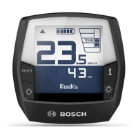
Active Navigation
The following figure shows an example of active navi-
gation with explanations of the depicted symbols.
n11
Distance to the destination
n12
Arrival time
n13
Destination
n14
Current position
n15
Range indicator battery
n16
Open and close panel (back to search)
n17
Switch between 2D and 3D view
n18
End active navigation
The following functions are also available:
Center view (only visible if the map has been
moved or the zoom function has been used)
Skip waypoints (only visible if the route has
been planned with intermediate destinations in
the online portal)
<AutoZoom 2D>
The <AutoZoom 2D> zoom function can be found in
the <Map Settings>. The map section is optimally
adapted depending on the speed.
<Rerouting>
If you would like to follow a precisely defined route or
a previously planned GPX track (e.g. on trails) ex-
actly, you can deactivate recalculation of the route.
The function can be activated and deactivated in the
<Rerouting> menu item under <Map Settings>.
<Trip Data>
i <Trip Distance>
Indicator for distance traveled
m <Trip Time>
Indicator for trip duration
n <Avg. Speed>
Indicator for average speed
o <Altitude>
Indicator for altitude
Bosch eBike Systems 1 270 U20 BN2 | (14.03.2023)

 Loading...