Do you have a question about the Flymaster NAV and is the answer not in the manual?
Details charging modes (Quick/Slow) and procedures for the Flymaster NAV battery.
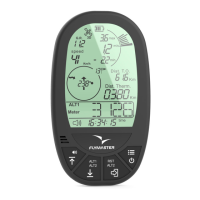
Explains the functionality of the four navigation keys in flight and menu modes.
Guides on menu navigation, option selection, and parameter adjustment using device keys.
Provides instructions for powering the NAV device on and off.
Describes the procedure to reset the NAV device in case of freezing or unresponsiveness.
Explains how to configure and manage screen layouts using the Flymaster Designer tool.
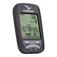
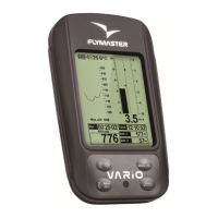
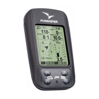
Details graphical elements providing information visually, such as Battery, Sound, GPS, and Vario.
Explains numerical data fields for displaying information like altitude, speed, and glide ratio.
Describes the main menu items and their functions, accessed via the S1 button.
Details actions available for selected waypoints, including adding, editing, and deleting.
Covers editing task points, including types, sequence, and parameters.
Explains how to define a competition task by setting waypoints, types, and times.
Allows postponing all defined times in a task forward by X minutes.
Provides functionality to override automatic task navigation and select a specific waypoint.
Displays a list of airspaces within 100km of the pilot's position.
Shows key data for critical airspaces like distance, altitude, floor, and ceiling.
Displays waypoints defined as Landings, sorted by necessary glide ratio.
Allows access to information about previously saved flights, identified by date and time.
Allows deletion of a selected flight from the instrument's memory.
Enables the deletion of all saved flights and track logs.
Details the instrument's memory capacity and data organization.
Displays GPS satellite reception, signal strength, and position dilution of precision (pdop).
Lists the different pages available in a typical layout, as defined in DESIGNER.
Details options to go to or disable individual pages from the Pages menu.
Explains how to disable pages and the effect on triggers and display.
Configures barometric altimeter calibration and time-related parameters like Vario Integrator.
Adjusts vario sound thresholds, frequency, volume, and configures audio alerts.
Sets advanced vario features like Damper, Cadence, Buzzer, and trace display options.
Configures screen contrast, inverse titles, language, units, and device reset options.
Manages pairing of wireless devices and sets Heart-G pulse threshold.
Defines user-defined data fields and assigns functions to FS keys for shortcuts.
Adjusts safety margin, turnpoint size, datum, and airspace warning parameters.
Outlines the steps for updating the NAV device firmware via a computer.
Guides on setting up the COM port in GPSDump for instrument communication.
Details the process of uploading waypoint files into the GPSDump software.
Explains how to download flight tracklogs from the instrument using GPSDump.
| Brand | Flymaster |
|---|---|
| Category | GPS |
| Model | NAV |
| Display | Color LCD |
| Screen Resolution | 320 x 240 pixels |
| GPS | Yes |
| Altimeter | Yes |
| Vario | Yes |
| Thermometer | Yes |
| G-Meter | Yes |
| Screen Size | 2.8 inches |
| Connectivity | USB |