PRIMUSr 1000 Integrated Avionics System
A28--1146--112--00
PRIMUS
â
660 Weather Radar System
B--2
The ground mapping (GMAP) function is used to improve resolution
andidentificationof small groundtargetsat shortranges.Thereflected
signalsfromgroundsurfacesaredisplayedasmagenta,yellow,orcyan
(most to least reflective).
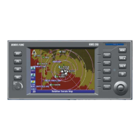
WEATHER RADAR CONTROLLER
Controls and Indicators
Controlsand display features described below arenumbered tomatch
the numbered callouts in figure B--1. All legend and controls on the
indicator that light are controlled by the dimming bus that controls the
aircraft panel.
AD--52931--R1@
SECTTGTSTABRCT
GAIN RADAR SLV TILT
+
--
MIN MAX
PULL
VAR
OFF
SBY
WX
GMAP
FP
TST
1 2 3 4 5
69 8 7
OFF
Weather Radar Controller
Figure B--1
1 RANGE SWITCHES
The range switches are two momentary contact buttons that are used
to set the operating radar range. WX ranges can be set from 5 to 300
NM full scale. In the flight plan (FPLN) mode, ranges of 500 and 1000
milescanbeset.Theuparrowselectsincreasingranges,andthedown
arrow selects decreasing ranges. One--half the selected range is
annunciated at the one--half scale range mark on the PFD or MFD.
NOTE: For dual controller installations, the weather radar range is
controlled by the on--side weather radar controller.
 Loading...