Do you have a question about the II Morrow Inc. Apollo 820 and is the answer not in the manual?
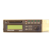
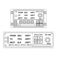
Explains the device's display elements, indicator lights, and physical controls.
Details the four operating modes: NAV, DB, FPL, and SYS, and how to select them.
Describes the manual's layout, including Action and Explanation columns for procedures.
Explains the concept of 'pages' and how to navigate through them using controls.
Details the various warning messages and indicators displayed by the unit.
Describes common alert messages and their meanings, such as countdown timer expiration.
Explains the display's division into fields and how NAV displays can be customized.
Illustrates and explains various Navigation (NAV) displays, including bearing, track, and distance.
Describes the unit's internal databases (Airport, VOR, User) and optional datacards.
Lists the types of optional datacards available for expanding database information.
Provides examples on how to read and understand information from airport and heliport databases.
Covers creating, storing, and editing flight plans with multiple legs and waypoints.
Explains how to set the time interval for automatic scrolling through NAV pages.
Provides an overview and critical warning for operating the Flybuddy GPS during its first use.
Details the procedure for powering on the unit and confirming initial settings like position.
Explains methods to enter initial latitude/longitude or airport identifier for positioning.
Guides on using controls to select and enter an airport identifier during start-up.
Instructs on setting the correct UTC date and time for accurate navigation.
Outlines the process for setting up and flying directly to a selected waypoint.
Describes how to find and navigate to the nearest airports, VORs, and user waypoints.
Explains how to use the NAV page to manage flight legs and waypoints for a journey.
Details how to search for waypoints within the database using their identifiers.
Explains how the system handles and displays waypoints that share the same identifier.
Guides on searching databases for airports, seabses, and heliports using city names.
Describes how to use the INFO button to access detailed waypoint information pages.
Covers procedures for creating, editing, deleting, and managing flight plans.
Provides instructions for creating, editing, and deleting custom user waypoints.
Explains how to start and stop the automatic scrolling through NAV pages.
Details how to view warning messages generated by the unit, such as GPS communications failures.
Explains how to view various alert messages, including low battery and arrival notifications.
Covers how to check GPS status, position accuracy, and satellite reception.
Guides on manually setting the Course Deviation Indicator (CDI) sensitivity.
Explains how to manually input magnetic variation for bearing calculations.
Describes how to select the units for ground speed display (knots, mph, kph).
Shows how to access and view the unit's software and database version numbers.
Details the procedure to activate the display test mode for checking screen functionality.
Guides on entering and verifying owner name and password for personalization.
Explains how to modify owner details like name, address, and phone number.
Guides on setting the duration for automatically scrolling through NAV pages.
Explains how to customize the information displayed on the NAV pages.
Describes how to reset customized NAV displays back to their original factory settings.
Guides on setting the countdown timer in hours, minutes, and seconds.
Addresses common operational problems and solutions encountered while flying.
Covers issues and troubleshooting steps relevant when the aircraft is parked or on the ground.
| Brand | II Morrow Inc. |
|---|---|
| Model | Apollo 820 |
| Category | GPS |
| Language | English |