1-1
Section 1 Overview
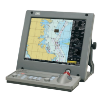
J-Marine NeCST*1 is the equipment of navigation aid which manage and share navigation information
included in Electronic Navigational Chart by displaying on big display. It is possible to improve
efficiency and optimize navigation planning by linking various function such as handwriting and various
system such as meteorological and oceanic prediction in J-Marine NeCST.
*1: NeCST stands for Navigational electronic Conning Station Table.
【Function of J-Marine NeCST】
• Route creating function
To create a route easily and flexibly with fingers or a stylus pen
• Electronic Navigational Chart display function
• NAVTOR ENC Service
• NeCST Emergency function
Enables the user to share information between ship and office in emergency.
• Display weather and maritime meteorology information function
Enables the user to create route with the information.
• Handwritingn function on the Electronic Navigational Chart
• Draw :Enables the user to freely write NGA on the chart.
• Template :Enables advance placement of planned work during navigation on the route.
• Sticker :Enables placement of a sticker as information when special route conditions or
situations are known in advance.
• Memo :Enables the user to tell the next user a message for him/her or an instruction from
the captain when relieved of watch.
• Synchronize information of handwritten and route function on ECDIS
To synchronize with JRC’s ECDIS (JAN-9201/7201, JAN-901B/701B) or FURUNO’s
(FMD-3100/3200/3300) and display, for example, a route created on ECDIS
• Sharing information function between ship and office
The following information in the ship can be collected and uploaded to the Smart Ship Viewer*1
• NMEA : The sensor data in the ship
• RMS : Data used for JRC original remote maintenance
• AIS : AIS data around own ship
• Route : Routes monitored by ECDIS (JAN-9201/7201)
• Alert : Alert information for each unit
*1: The Smart Ship Viewer is the JRC corporate service for managing ship information from land.
Can check each uploaded data from the land.
• Each useful tool function for entering handwritten information or route planning
• Divider :Enables measurement of the distance and bearing between two points.
• Measure :Enables measurement of the distance and time between consecutive points.
• Circle :Places a concentric circle at any point and enables measurement and
comparison of distances.
• Loupe :Enables display of the latitude/longitude and chart information of any point.
• Ruler :Places a ruler on the chart screen and enables measurement of any distance and
angle.
• Simplified check function of safety contours and dangerous areas on the route
It is necessary to modify before synchronization with ECDIS
• Display the own ship’s position and AIS targets function on the Electronic Navigational Chart
• Display function of Navtex information
• Display in TM/RM function
 Loading...