Do you have a question about the Leica MX420 and is the answer not in the manual?
Details the various MX420 models available and their differences.
Explains the meaning of safety symbols used throughout the manual.
Lists other related documentation for the MX420 system.
Provides essential information regarding GPS accuracy, DGPS, and navigational aids.
Details the various MX420 models available and their differences.
Explains the meaning of the traffic light indicators for DGPS status.
Explains the meaning of the traffic light indicators for GPS status.
Displays a 3D runway view of the active route with navigation markers.
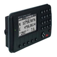
Shows bearing, range, COG, SOG, and cross-track error.
Manages the current active route, including creating, editing, and skipping waypoints.
Explains four methods to create multi-waypoint routes for navigation.
Guides the user through the process of creating and modifying waypoints.
Describes how to protect waypoints from modification or accidental deletion.
Shows MOB position, bearing, and distance for quick return.
Sets up the AIS system by identifying the transponder type.
Manages the built-in beacon receiver settings for DGPS operation.
Guides configuration of AIS menus for transponder and static updates.
Accesses various AIS data screens like Own Ship Data.
Displays unit details and performs self-tests.
Explains the procedure for safely powering down master and slave units.
| Display Size | 4.3 inches |
|---|---|
| Display Resolution | 480 x 272 pixels |
| Pre-installed Maps | Yes |
| Voice Guidance | Yes |
| Bluetooth | Yes |
| SD Card Slot | Yes |