Do you have a question about the Lippmann Geophysikalische Messgeräte 4point light and is the answer not in the manual?
Provides contact details for Erich Lippmann - Geophysical Instruments, including address, phone, and email.
Details the copyright holder and reprint permissions for the manual.
Information about the manufacturer, Erich Lippmann - Geophysical Instruments.
Instructions for obtaining information regarding the instrument's guarantee.
Explains notation, symbols, instructions, and warnings used in the manual.
Essential safety instructions and warnings for safe instrument operation.
Guidelines for maintaining the instrument, including battery care and calibration.
Instructions for the proper and environmentally friendly disposal of the instrument.
Describes the basic measuring system and four-electrode arrays.
Explains the instrument's capability to produce constant output currents.
Details the selectable AC output current frequencies and recommendations.
Discusses methods for suppressing noise during measurements.
Explains how the instrument measures phase shift for IP detection.
Information on powering the instrument using internal or external sources.
Details the integrated automatic charging device and its settings.
Outlines the five different modes for acquiring resistivity data.
Describes the two possibilities for instrument calibration: offset and full.
Explains how to connect the instrument to a PC for data exchange.
Details transferring data to an FTP server via GPRS modem.
Provides guidance on common errors and how to avoid them.
Step-by-step guide on how to turn on the 4point light 10W instrument.
Instructions on how to properly switch off the instrument.
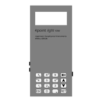
Explanation of the keypad layout and key assignments for instrument control.
Presents the main menu options for selecting operating modes and settings.
Detailed guide on using the Vertical Electrical Sounding (VES) mode.
Instructions for operating the instrument in Mapping mode for archaeological surveys.
Guide to controlling the instrument remotely via a PC.
Instructions for performing data acquisition in Tomography mode.
Details on repeating data acquisition in fixed intervals in Monitoring mode.
Explains the 'Contact' function for estimating output voltage quality.
Information on determining DC voltage between M and N for self-potential measurements.
Procedure for deleting all saved data from the instrument.
Guide to adjusting general instrument settings like date, time, and communication.
Covers test functions for GSM, GPRS, FTP, and calibration modes.
List of general error messages that may occur during instrument use.
Specific error messages that may appear on the PC in remote mode.
Provides geometry factors and calculation methods for electrode configurations.
Details the data formats used for VES, Mapping, Multimapping, and Monitoring.
Lists error numbers related to GPRS data transfer between instrument and FTP server.
Step-by-step instructions for installing new software on the instrument.
Guide to using HTerm for data transfer and terminal operations.
| Brand | Lippmann Geophysikalische Messgeräte |
|---|---|
| Model | 4point light |
| Category | Measuring Instruments |
| Language | English |