Do you have a question about the MATO MTS600 Series and is the answer not in the manual?
Safety guidelines for using the instrument in various environments and handling it.
Precautions related to using the power supply and charging batteries safely.
Safety instructions for mounting and using the tripod with the instrument.
Warning and precautions regarding the use of the laser plummet.
Guidelines for protecting the instrument from moisture and dust particles.
Instructions on properly mounting and using the instrument for measurements.
Advice on handling the instrument in varying temperatures and avoiding shocks.
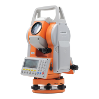
Identification and labeling of the various components of the total station.
Step-by-step instructions for safely removing and storing the instrument.
Guidance on battery cautions, charging procedures, and mounting/removing.
Overview of the instrument's display screen and the layout of the keyboard.
Explanation of the function and purpose of each key on the instrument's panel.
Instructions on how to enter numbers and letters using the instrument's keypad.
Steps for correctly positioning and securing the instrument on the tripod.
Procedures for leveling the instrument using circular and plate levels.
Method for accurately centering the instrument over the survey point.
Final steps to ensure the instrument is perfectly leveled and stable.
Procedures for measuring horizontal and vertical angles accurately.
Step-by-step guide to measuring the included angle between targets.
Methods for setting horizontal angles using keys or by holding the angle.
How to switch between right and left angle display modes.
Configuring settings for distance measurement, including atmospheric and prism corrections.
Calculating and applying atmospheric correction for accurate distance measurements.
Setting the prism constant for accurate distance calculations.
Overview of available distance measurement modes like Fine, Rapid, and Tracking.
Switching between different display combinations for distance measurement results.
Transferring measured distance and angle data to external devices.
Establishing the coordinate system by setting the instrument station and orientation.
Inputting the initial coordinates for the instrument station.
Loading previously stored coordinate data for use in station setup.
Setting the backsight point direction angle directly or via coordinates.
Setting out points based on distance and horizontal angle from a reference.
Setting out points using known coordinate data.
Choosing or creating a JOB file for organizing measurement data.
Inputting and saving the instrument station's position and orientation.
Inputting and storing the backsight direction angle.
Measuring and recording distance, angle, or coordinate data.
Managing JOB files, including listing, selecting, and viewing records.
Viewing and deleting individual records within a JOB file.
Selecting a different JOB file for current measurement data.
Deleting entire JOB files from the instrument's memory.
Entering coordinate data for known points into memory.
Viewing and deleting stored known point coordinate data.
Clearing all known point coordinate data from memory at once.
Entering custom codes for use during data recording.
Viewing and deleting previously entered codes.
Configuring communication parameters like baud rate for data transfer.
Transferring JOB data from the instrument to a PC.
Importing known point coordinate data from a PC into the instrument.
Calculating instrument station coordinates using known points.
Method for calculating station coordinates using two known points.
Calculating station coordinates using more than two known points.
Measuring distances and angles to points using an offset for inaccessible targets.
Measuring distances and angles between multiple points without moving the instrument.
Modifying the starting point for missing line measurements.
Measuring height using prism height input for remote objects.
Measuring height without prism height input for remote objects.
Calculating polygon area by measuring boundary points directly.
Calculating polygon area using pre-entered known point coordinates.
Overview of configurable parameters and their available options.
Correcting measurement errors due to atmospheric refraction and earth curvature.
Applying scale correction for distance measurements based on elevation and projection.
Step-by-step guide to changing instrument settings.
Procedures for checking and adjusting the instrument's levels.
Checking and adjusting the instrument's reticle.
Steps for adjusting the telescope axis for proper alignment.
Checking and adjusting the optical plummet.
Checking for vertical circle index error.
Procedure to adjust the vertical circle index error.
Checking the tilt compensator zero point error.
Adjusting the tilt compensator zero point error.
Verifying the additive distance constant of the instrument.
Adjusting the instrument's additive distance constant if needed.
Technical specifications for the instrument's telescope.
Specifications related to distance measurement capabilities.
Specifications for angle measurement accuracy and display.
Specifications for the instrument's battery type, capacity, and working duration.
Operating temperature limits for the instrument.
Physical dimensions and weight of the instrument.
| Brand | MATO |
|---|---|
| Model | MTS600 Series |
| Category | Measuring Instruments |
| Language | English |