Do you have a question about the Matsutec HP-33 and is the answer not in the manual?
Covers essential warnings and precautions for safe operation of the equipment.
Provides critical safety guidelines for installation personnel to prevent hazards.
Welcomes the owner and introduces the product, offering general guidance.
Highlights the key capabilities and functionalities of the HP-33 GPS Navigator.
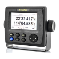
Explains the function of each key and button on the HP-33 unit.
Details the procedure for powering the unit on and off, including status indications.
Guides users on adjusting screen and button brightness for optimal visibility.
Describes the various display screens available on the unit and how to select them.
Explains the 3D view of boat progress towards a destination.
Details how the unit provides steering information and guidance.
Shows how to display essential navigation data like position, speed, and course.
Provides information on GPS and GEO satellite status for position fixing.
Covers customization of user-defined display screens for navigation data.
Introduces the menu structure and how to navigate through settings.
Explains the process for entering text and numbers in various menu fields.
Describes how to mark and navigate to a Man Overboard position.
Explains how to adjust the zoom level on the plotter and highway displays.
Details how to move the cursor on the plotter display for selecting points.
Describes how to pan or center the display on the plotter.
Covers setting the frequency for recording the boat's track.
Allows selection of colors for displaying recorded tracks.
Explains methods for deleting recorded track data.
Details the process for clearing all recorded track data from the unit.
Guides on adding new navigation points (waypoints) to the unit.
Explains automatic waypoint creation based on course changes.
Covers options for showing waypoint names on the display.
Details how to modify existing waypoint information like position or name.
Describes how to relocate existing waypoints on the plotter display.
Explains how to remove individual waypoints from the unit.
Covers deleting all stored waypoints.
Guides on creating a sequence of waypoints to form a navigation route.
Covers modifying existing routes, including waypoints within them.
Explains how to add a waypoint into an existing route sequence.
Allows skipping waypoints within a route without deleting them.
Details how to remove individual routes from the unit.
Covers deleting all stored routes.
Allows setting a navigation destination by placing the cursor on the plotter.
Guides on selecting a stored waypoint as the navigation destination.
Explains how to set an entire route as the navigation destination.
Details procedures for ending the current navigation destination.
Lists the types of alarms the unit can generate.
Allows customization of buzzer sounds for different alarms.
Guides on configuring specific alarm parameters and thresholds.
Explains the meaning and behavior of various alarm conditions.
Covers settings affecting the plotter display, like COG line and bearing references.
Allows configuration of GPS parameters such as datum, navigation method, and smoothing.
Details settings for the Satellite-Based Augmentation System (SBAS).
Covers options for how latitude and longitude are displayed.
Enables customization of system-wide settings like units, time, and language.
Allows customization of the content shown on user-defined display screens.
Explains how to transfer waypoint and route data between the unit and a PC.
Provides guidance on regular care to keep the unit in optimal performance.
Offers solutions for common operational issues and symptoms.
Explains how to view error messages and their meanings.
Describes how to run system tests to diagnose potential hardware or software issues.
Details how to reset various data types to their default or factory settings.
Lists all standard components included with the HP-33 GPS Navigator.
Covers considerations and procedures for mounting the main unit.
Provides key points to consider for optimal placement and mounting of the unit.
Explains the process for mounting the unit on a desktop or table.
Details guidelines and considerations for installing the GPS antenna.
Explains the pinouts and connections for power and data interfaces.
Specifies the voltage and current requirements for the unit's power supply.
Lists operating temperature and humidity ranges for the unit.
States the color codes for the antenna and receiver units.
| Brand | Matsutec |
|---|---|
| Model | HP-33 |
| Category | Marine GPS System |
| Language | English |