Do you have a question about the Navionics Geonav 5 Touring and is the answer not in the manual?
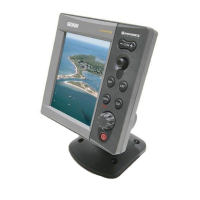
Provides an overview of the GEONAV chart plotter, its integration capabilities, and chart functionality.
Details the general features and electrical requirements of the GEONAV unit.
Outlines memory capacity, interface options (NMEA), and specifications for the optional fishfinder.
Covers essential installation precautions, electromagnetic interference avoidance, and cleaning advice.
Provides instructions for mounting the main GEONAV unit and the optional fishfinder black-box.
Details the pin configuration for the power supply and NMEA 0183 data connections.
Guides on how to properly install and remove the CompactFlash data cartridge.
Explains the functions of the joystick for cursor movement and menu navigation.
Details the specific operations performed by the ENTER, GOTO, CLR, and EXIT buttons.
Details how to access and run the GEONAV's built-in diagnostic program.
Introduces Navionics charts, scale adjustment, and chart detail display options.
Covers turning the GEONAV unit on/off and the initial welcome screen.
Explains depth sounder integration and the automatic navigation mode.
Describes manual cursor use, chart rotation, and automatic chart scaling features.
Details Electronic Bearing Line, Variable Range Marker, Easy Pilot, and position calibration.
Covers setting local time, adjusting brightness, color selection, and data backup.
Explains fishfinder integration and the backup process for routes and tracks.
A brief guide to get started with the GEONAV unit and its basic functions.
Differentiates between the Cursor mode for input and Navigation mode for display.
Explains the zoom status, chart range, and measurement units shown in the range window.
Details the information displayed in navigation windows, including speed, course, and time.
Describes the depth sounder window and the satellite tracking information window.
Covers display of general position info, tide/current forecasts, and fishfinder data.
Lists and describes the primary options accessible from the main menu.
Guides on creating, editing, deleting routes, and managing waypoints.
Explains how to start, stop, store, recall, and manage recorded tracks.
Details on inserting markers, changing their properties, and managing them.
Guides for navigating to specific ports or nearest services based on location.
Explains how to navigate using geographical coordinates or range and bearing values.
Details the MOB function for marking a position in case of accidental overboard.
Describes how the GEONAV unit interfaces with and controls an autopilot system.
Covers display modes, safety depth limits, chart detail, and photo overlays.
Details anchor alarm, XTD alarm, navigation settings, and 3D display options.
Explains how to configure fishfinder sensitivity, depth range, and chart speed.
Details advanced sonar features, sensitivity, and transmission parameter adjustments.
Covers fish alarm settings, transducer calibration, and other fishfinder configurations.
Guides on setting measurement units, language, and selecting data input sources.
