Do you have a question about the Navman TRACKFISH 6500 and is the answer not in the manual?
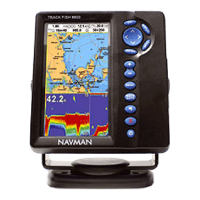
Provides a compact overview of the TRACKFISH 6500 marine chartplotter and fishfinder.
Details on cleaning the TRACKFISH screen and maintaining its components for optimal performance.
Explains the use of C-MAP chart cards and C-MAP user cards for navigation and data storage.
Describes the function of each button on the TRACKFISH unit for easy operation.
Instructions for manually turning the TRACKFISH on/off and configuring auto power settings.
Details the Man Overboard function to save position and navigate back to the boat's location.
Explains how the TRACKFISH detects and alerts the user to various alarm conditions.
Overview of the different main displays available on the TRACKFISH unit.
Introduces the two primary navigation methods: going to a point or following a route.
Step-by-step guide on navigating to a specific point using chart and highway displays.
Detailed explanation of the chart display interface and its elements.
Describes the two chart modes: Centre on boat and Cursor mode.
How to use the calculator to plot courses, measure distances, and bearings between points.
Explains the highway display's bird's eye view of the boat's course to a destination.
Describes how to view the list of entered waypoints with their details.
Covers creating, moving, editing, displaying, and deleting waypoints on the TRACKFISH.
Details how to view the list of created routes, including start, end, and total distance.
Instructions for creating, editing, deleting, and navigating routes on the TRACKFISH.
Information on GPS satellites and the GPS position, including status and signal strength.
Explains how the sonar transducer works and how echoes are converted and displayed.
Guidance on understanding sonar displays, echo appearance, and scroll speed settings.
Details on using 50 kHz and 200 kHz frequencies for optimal fishfinding results.
Explains how to set and use the range modes (Auto and Manual) on the sonar display.
How to adjust gain and threshold settings to control sonar detail and reduce noise.
Describes the standard sonar history display for single or mixed frequencies.
Explains the sonar display with a zoomed section for detailed analysis of history.
Details the display showing sonar history and a flat bottom trace for comparison.
Shows split sonar histories for 50 kHz and 200 kHz frequencies simultaneously.
Describes the A-Scope display for real-time echo strength analysis, useful for setting gain.
Explains how to configure the Gauges display for boat data like speed and RPM.
Details on selecting and displaying various data fields and graphs on the Data display.
Instructions for accurately updating fuel levels in the TRACKFISH.
Describes the fuel display, showing used fuel, remaining fuel, flow, speed, economy, and range.
Guide on creating and using fuel consumption curves to assess boat performance.
Explains how the Tides display shows tide information from C-MAP charts.
Describes the file list on a user card, including saving and loading data.
Details the Distress, Poll, and Buddy track displays for DSC radio integration.
Instructions on how to display boats, go to boats, create/edit waypoints, and delete boats.
Shows software version, hardware details, and TRACKFISH connector information.
Configures system settings like language, backlight, night mode, key beep, and factory reset.
Customizes chart settings including rotation, palette, map datum, and plotter mode.
Adjusts sonar settings like frequency, scroll speed, fish symbols, range, gain, and threshold.
Configures GPS settings including source, static navigation, and speed/course filters.
Sets up fuel functions, including tank size, number of engines, and calibration.
Enables and configures various alarms like arrival radius, XTE, danger, and low fuel.
Lists all components included with the TRACKFISH unit for installation.
Guides on selecting a position and mounting the display unit using flush or bracket methods.
Instructions for wiring the power/data cable for basic or auto power operation.
Details on selecting and installing the GPS antenna and configuring DGPS options.
Guidance on fitting the transom mount sonar transducer and connecting it.
Final steps for initial setup, language selection, and a test run after installation.
Provides physical, electrical, and environmental specifications for the TRACKFISH unit.
Troubleshooting common issues like the unit not turning on or beeping without display.
Addresses GPS fix issues, position inaccuracies, and chart datum discrepancies.
Troubleshooting sonar issues such as erratic operation, no bottom display, or interference.
Defines key terms and acronyms used in the TRACKFISH manual.
Lists contact details for Navman support and distributors worldwide.
| Brand | Navman |
|---|---|
| Model | TRACKFISH 6500 |
| Category | Fish Finder |
| Language | English |
