

M
Mark HughesAug 1, 2025
What to do if my Onwa KP-32 Marine GPS System displays 'GPS NO FIX!'?
- Jjennifer46Aug 1, 2025
If your Onwa Marine GPS System displays 'GPS NO FIX!', it indicates there is no GPS signal. You should check the antenna cable.
What to do if my Onwa KP-32 Marine GPS System displays 'GPS NO FIX!'?
If your Onwa Marine GPS System displays 'GPS NO FIX!', it indicates there is no GPS signal. You should check the antenna cable.
Why does my Onwa KP-32 Marine GPS System show 'BATTERY ALARM!'?
The 'BATTERY ALARM!' message on your Onwa Marine GPS System means the voltage of the battery in the display unit is low. You should request a replacement.
What to do if Onwa KP-32 displays 'BACKUP ERROR DATA!'?
If your Onwa Marine GPS System displays 'BACKUP ERROR DATA!', it means the RAM data is corrupted. Try to clear the backup data.
What causes 'HIGH VOLTAGE!' error on Onwa Marine GPS System?
The 'HIGH VOLTAGE!' error on your Onwa Marine GPS System means the power source voltage is too high.
What does 'LOW VOLTAGE!' mean on my Onwa KP-32?
The 'LOW VOLTAGE!' error on your Onwa Marine GPS System indicates that the power source voltage is too low.
What to do if my Onwa Marine GPS System shows 'RAM ERROR!'?
If your Onwa Marine GPS System displays 'RAM ERROR!', you should request service.
What to do if my Onwa KP-32 displays 'ROM ERROR!'?
If your Onwa Marine GPS System displays 'ROM ERROR!', you should request service.
Essential guidelines for safe and proper operation of the GPS navigator, focusing on user safety.
Welcome message to the owner, introducing the KP-32 GPS Navigator and ONWA's reputation.
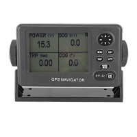
Highlights key capabilities and specifications of the KP-32 GPS Navigator, including its components and functions.
Details the functions of the GPS navigator's control panel buttons and cursor pad for navigation and operation.
Describes the different display modes available on the GPS navigator, such as Plotter, Highway, and Nav Data.
Guides users on navigating the GPS navigator's menu system to access settings and functions.
Explains how to use the simulation mode for practicing operations and familiarizing with the GPS navigator's features.
Instructions on adjusting the horizontal display range for the plotter and highway displays for optimal viewing.
Details how to use the cursor pad to navigate and select items on the GPS navigator's display.
Explains how to shift the display content on the plotter screen using the cursor pad.
Describes how to automatically or manually center the ship's position on the plotter display.
Guides on configuring track recording intervals and how to stop plotting ship's track.
Provides instructions on how to permanently erase the recorded ship's track data from the device.
Explains various methods for entering and saving waypoints, including cursor position and own ship position.
Details the procedure for marking the Man Overboard (MOB) position and setting it as a destination.
Instructions on how to display waypoint names using different options like GOTO, RTE, or ALL.
Covers editing waypoint attributes such as name, shape, and comment from the waypoint list.
Guides on how to erase individual waypoints or all waypoints from the device's memory.
Explains how to input speed manually or automatically to calculate Time-to-Go (TTG) and Estimated Time of Arrival (ETA).
Details how to create routes by defining a sequence of waypoints, covering cursor, route menu, and track-based methods.
Provides instructions on how to edit existing routes, including replacing, inserting, or removing waypoints.
Guides users on how to delete entire routes from the GPS navigator's memory.
Explains how to set the destination by placing the cursor at a desired location on the plotter display.
Details how to select a waypoint from the list or nearest waypoints to set as the destination.
Instructions on setting an entire route as the destination, allowing navigation through the defined path.
Describes how to set a user-defined waypoint as the destination via the GOTO options.
Provides steps to cancel the currently set destination and return to normal operation.
Explains how to activate and configure arrival and anchor watch alarms to alert the user about proximity to a waypoint or drift.
Details the setup and function of the Cross Track Error (XTE) alarm to warn about deviations from the intended course.
Information on setting speed alarms to alert when the vessel's speed is above or below a specified threshold.
Explains how to set a time-based alarm, functioning like an alarm clock for timely notifications.
Guides on setting a trip alarm that activates when the vessel travels a distance exceeding a preset value.
Details how to set an odometer alarm, which triggers when the total distance traveled exceeds a set limit.
Allows selection of different buzzer types (short, long, constant) for audible alarms.
Instructions on calculating range, bearing, Time-to-Go (TTG), and Estimated Time of Arrival (ETA) between points.
Explains how to set the bearing reference to True or Magnetic for course and waypoint display.
Information on magnetic variation and how to set it manually or automatically for accurate navigation.
Describes the preprogrammed geodetic chart systems and how to select the appropriate one for navigation.
Guides on changing units of measurement for distance and speed (e.g., nautical miles, knots).
Details how to set the time difference for local time display and choose between 12/24 hour formats.
Explains GPS setup options for smoothing, averaging, and position offset to improve fix accuracy.
Covers configuring user-defined displays, including digital data layout and speedometer settings.
Provides instructions for resetting the trip meter and odometer to zero.
Guides on transferring waypoint and route data between the device and a PC via serial connection.
Allows selection of the display language for the GPS navigator from a list of available options.
Regular maintenance checks to ensure optimal performance and longevity of the GPS navigator.
Instructions on how to safely replace the fuse in the power cable to protect against overcurrent.
Explains how to view satellite status, signal levels, and DOP values for GPS and GEO satellites.
Details how to run diagnostic tests on the device's components like ROM, RAM, and LCD for proper operation.
Guides on clearing GPS data, menu settings, and backup data to reset the device to default configurations.
Covers mounting considerations for the display unit, including location, ventilation, and shock resistance.
Provides guidance on mounting the antenna unit, including cable handling and placement away from interference sources.
Illustrates the wiring connections for the display unit, antenna, and power supply, including grounding.
Steps for configuring initial settings, including output data formats and sentences for external equipment.
| Brand | Onwa |
|---|---|
| Model | KP-32 |
| Category | Marine GPS System |
| Language | English |