Do you have a question about the Prestigio GEOVISION 5000 and is the answer not in the manual?
Covers risks of electric shock, proper handling, accessory use, and environmental hazards.
Guidance on product disposal and compliance with EU directives.
Details on the items included in the Prestigio GPS package.
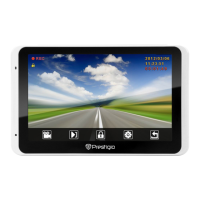
Identification of the device's parts, including screen, buttons, and ports.
Instructions for attaching the device to the cradle and selecting an optimal location.
Guidance on charging the device and calibrating the stylus for accurate input.
Steps for powering on, understanding the home screen, and basic navigation controls.
Steps to power on the device and start the GPS navigation application.
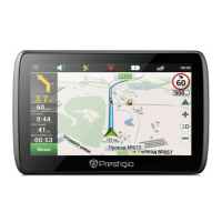
Description of the main screen elements and their functions in GPS navigation.
Explanation of map view options, zoom controls, speed limits, and battery status.
Details on GPS/GLONASS connection status, route progress, and traffic lane information.
How to mark points on the map, save waypoints, and record travel tracks.
Step-by-step guide to creating routes to specific addresses using the navigator.
Instructions for setting a route to a point directly on the map.
Guidance on creating routes by specifying multiple points on the map.
Detailed list of the GPS navigator's hardware components, dimensions, and operating conditions.
| operation humidity | 45% ~ 80% non-condensed |
|---|---|
| storage humidity | 30% ~ 90% non-condensed |
| storage temperature | -10°C ~ +60°C |
| operation temperature | 0°C ~ +50°C |
| battery capacity | 850 mAh |
|---|---|
| battery type | Li-Polymer battery |
| display size | 5 inches |
|---|---|
| display type | TFT touch LCD |
| resolution | 480 x 272 pixels |
| ram | 128 MB DDR3 |
|---|---|
| flash memory | 4 GB |
| memory card support | micro SDHC card up to 8 GB |
| usb | USB 2.0 |
|---|---|
| memory card slot | Micro SD (micro SDHC compatible) |
| dimensions | 131.8 x 92 x 10.3 mm |
|---|---|
| weight | 160 g |