Do you have a question about the Rand McNally TND 730 and is the answer not in the manual?
Important safety instructions for using the device, including navigation, installation, and general handling.
Lists all items provided with the Rand McNally IntelliRoute TND device.
Instructions for charging the device battery and installing the windshield mount securely.
Explains the device's physical components and the initial startup procedure, including tutorials and legal consent.
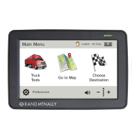
Overview of the Main Menu screen, detailing each icon and its function for device operation.
Introduces main categories for device configuration: General, Route, and Map settings for customization.
Configuration options for truck-specific information such as Hazmat Type, Height, Width, and Trailer settings.
Customizes various driving warnings, alerts, and display size preferences for the device.
Configures appearance settings like Skin Style, Vehicle Type, time zones, and team driving options.
Covers load options, screen interaction, tutorial access, keyboard layout, voice, language, units, and clock format.
Settings to customize route calculation, including ETA adjustments, avoidance options, and recalculation preferences.
Options to customize map display, including style, zoom behavior, icon visibility for POIs, and route color.
Explains how to access the Destinations window from the Main Menu to find locations.
Provides tips for entering addresses, including auto-complete features and handling common city/street name variations.
Details methods to input new destinations: by address, city center, intersection, or geographic coordinates.
Step-by-step guide for searching and selecting addresses, including city, street, and house number entry.
Instructions for routing to city centers and specific street intersections by entering relevant details.
Guide on how to input destinations using latitude and longitude coordinates, including format options.
Instructions for managing saved locations in the Address Book, including adding new entries and routing to them.
Explains how to create, manage, and add addresses to custom groups within the Address Book.
Instructions for creating multi-stop trips, adding multiple destinations, and managing trip stops.
Details how to automatically optimize or manually reorder stops within a multi-stop trip for efficient routing.
Explains how to select, start, and manage saved multi-stop routes, including deleting unwanted routes.
Describes interactive map features like adding interim stops, avoiding roads/areas, setting origin, routing, and checking Wi-Fi.
Instructions for creating and managing lists of routes, roads, or areas to avoid, including detouring around specific segments.
Explains how to search for points of interest (POIs) near your truck, in a city, along your route, or at your destination.
Details various categories of Points of Interest (POIs) for searching, such as Travel Centers, Truck Services, and CAT Scales.
Guide to searching for consumer-related points of interest, including selecting categories and subcategories.
Instructions on how to filter truck-specific POIs by amenities to find suitable locations like truck stops.
Explains how to use the Local Search feature to find businesses, restaurants, and services using keywords or categories.
Details the various options available in destination confirmation windows, such as setting origin, adding via points, and saving to address book.
Information on handling toll costs, comparing routes with and without tolls, and setting toll preferences.
Explains the various elements displayed on the Route Map Window, including maneuvers, road names, and time/distance.
Displays upcoming exit information, including amenities, to help drivers plan.
Options for customizing route display, including detailed maneuvers, trip summaries, and highway views.
Provides an overview of the Virtual Dashboard, showing trip progress, speed limits, sunrise/sunset times, and odometer readings.
Instructions for manually or automatically resetting trip information, including odometer and timer data.
Details Junction View and Turn View features that provide visual guidance for upcoming maneuvers and lane assist.
Options for managing routes, including detouring, accessing avoided roads, setting origin, and saving locations.
Guide to connecting to Wi-Fi hotspots for device features like weather and traffic updates, including setup and management.
Instructions for viewing current weather and forecasts, selecting weather overlays, and adjusting display transparency.
How to search for fuel prices at stations, sort by distance/price, and filter by fuel type or brand.
Overview of the Truck Tools menu, listing features like Truck Info, Timers, Warnings, and Quick Planner.
Detailed management of driving session, total hours, and maintenance timers, including reset options.
Instructions for viewing and managing mileage logs by quarter, year, state, or date, and deleting log entries.
Explains how to record travel paths (trails) using GPS coordinates, view them on the map, and manage trail details.
Steps to enter fuel purchase details, edit logs, and view fuel economy and purchase history by state or month.
Tool to estimate mileage, driving time, and cost between two cities, allowing adjustment of average speed.
Provides access to emergency and key phone numbers for states and provinces via the Rand McNally Road Atlas.
Utility tools including a calendar, notepad for notes, and a unit converter for various measurements.
Details the Traffic Everywhere feature for viewing traffic events, selecting routes based on traffic, and managing traffic settings.
Visual guide to common traffic icons used on the map, explaining their meaning such as accidents, construction, and road conditions.
Information on the Rand McNally Dock software for upgrades, map updates, and accessing additional features and support.
Introduces TripMaker, an online tool for planning trips with multiple stops and downloading them to the TND device.
Guide to using custom POIs, including types, formatting rules for .csv files, and examples for destinations or alerts.
Step-by-step instructions for loading custom POI files onto the device using the Rand McNally Dock software.
Instructions for exporting mileage breakdowns and fuel purchase data to a computer in .xls or .csv format.
How to use the "Tell Rand" feature to send messages about construction, restrictions, or other feedback to Rand McNally.
Lists websites for Rand McNally product information, support, GPS accessories, and social media channels.
| Brand | Rand McNally |
|---|---|
| Model | TND 730 |
| Category | Car Navigation system |
| Language | English |