Do you have a question about the Toyota TNS700 and is the answer not in the manual?
Explains the meaning of warning symbols used in the manual.
Emphasizes safe driving, driver responsibility, and avoiding system distractions.
Details different methods for searching and selecting destinations.
Explains how to initiate route guidance after setting a destination.
Details the various screens displayed during route guidance.
Explains how to add, reorder, and delete destinations in a route.
Allows users to set preferences for route calculation and conditions.
Explains how to display POI icons, view route overview, preview, and trace.
Covers pausing and resuming navigation guidance.
Details how to adjust the volume of voice guidance.
Allows saving settings for multiple users and configuring system options.
Manages saved locations, home address, and areas to avoid.
Provides information on vehicle maintenance schedules and dealer details.
Allows scheduling memos and using them for route guidance.
Covers adjusting screen brightness, contrast, and other display settings.
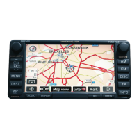
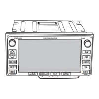
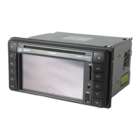
Provides a quick overview of audio system controls and buttons.
Explains basic functions and operation of the audio system.
Details how to tune stations, preset frequencies, and use RDS features.
Covers inserting, ejecting, playing discs, and managing tracks.
Explains the functions of steering wheel controls for the audio system.
Offers tips and notices for optimal audio system performance.
Details known limitations and factors affecting navigation system accuracy.
Provides information on map database version and how to obtain updates.
Details functions related to map display and searching destinations.
Covers setting up and managing route guidance.
Covers initial system displays and basic operational touch screen guidance.
Explains how to view and interact with the map display and its elements.
Provides step-by-step guides for common navigation tasks like guiding to a route.
Details how to adjust the screen's tilt for optimal viewing.
Describes the system startup sequence and the initial caution screen.
Explains how to select the desired language for the system interface.
Informs about when to replace parts and displays dealer information.
Alerts users to memo entries at specified dates and times.
Provides guidance on touching screen buttons and handling unresponsiveness.
Details how to input letters, numbers, and symbols using the on-screen keyboard.
Explains how to navigate and select items from list displays.
Describes how to scroll through lists and view complete item names.
Explains how to sort lists by various criteria like distance, date, or name.
Explains how to view help for destination, setup, and menu screens.
Shows how the current vehicle position is displayed on the map screen.
Explains how to scroll the map by touching and holding the screen.
Allows setting a specific map point as a destination using scroll function.
Details how to mark a specific location on the map as a memory point.
Shows how to view details of Points of Interest (POI) icons on the map.
Covers adding, replacing, or deleting destinations and memory points.
Displays destination name, address, and phone number, with delete option.
Allows choosing different screen layouts like single or dual map views.
Describes the standard single map view and how to access it.
Explains how to display the map split into two sections for different views.
Shows vehicle position with a compass instead of a map.
Details how to change the map scale for different zoom levels.
Explains how to switch between North-up and Heading-up map orientations.
Guides through finding a destination using Points of Interest (POI).
Allows selecting a destination by directly touching a location on the map.
Enables searching for destinations by entering names of intersecting streets.
Explains how to search for destinations using motorway entrances or exits.
Allows setting a destination by entering geographical coordinates.
Explains how to search for destinations using registered phone numbers.
Covers route search, selection of routes, and changing road preferences.
Details how to suspend/resume guidance and activate demo mode.
Warns about obeying traffic rules and potential inaccuracies in guidance.
Allows users to set preferences like avoiding motorways or tolls.
Explains how to select from recommended, alternative, or shortest routes.
Explains the information displayed on the route guidance screen.
Details information shown during motorway driving, like distances to exits.
Describes the guidance screen shown when approaching motorway exits.
Explains the intersection guidance screen with lane information.
Displays a list of upcoming turns for route guidance.
Provides visual arrows indicating upcoming turns on the route.
Illustrates common voice prompts for navigation instructions.
Shows estimated travel and arrival times to the destination.
Explains how to add subsequent destinations to an existing route.
Allows users to rearrange the sequence of multiple destinations in a route.
Details how to delete single or all destinations from a route.
Allows setting criteria like 'Quick' or 'Short' for route calculation.
Explains how to detour around traffic jams or road closures.
Lets users set preferences for motorways, tolls, ferries, etc.
Describes how to start route guidance from a road parallel to the main route.
Explains how to display various Points of Interest (POI) categories on the map.
Allows selection of up to 5 POI categories to display on the map.
Shows a list of POIs within a specified radius of the current position.
Guides on selecting a POI icon directly on the map as a destination.
Displays the complete route from the current position to the destination.
Allows previewing the list of roads and turns for the route.
Enables recording travelled routes and replaying them on the display.
Covers pausing and resuming navigation guidance.
Details how to adjust the volume of voice guidance.
Allows saving settings for multiple users.
Manages saved locations, home address, and areas to avoid.
Configures various system settings.
Provides traffic information via RDS-TMC.
Explains how to suspend the route guidance.
Explains how to restart the suspended route guidance.
Details how to adjust the voice guidance volume and enable adaptive control.
Allows saving system settings for up to three different users.
Covers switching between user profiles and deleting them.
Explains how to save locations as memory points for easy access.
Details how to modify attributes like icon, name, and location of memory points.
Covers the process of removing saved memory points.
Allows setting and removing the home address for quick navigation.
Explains how to register locations to be avoided in route calculation.
Details how to modify the name, location, or size of avoided areas.
Covers the process of removing registered areas from the avoid list.
Explains how to clear the history of previously entered destinations.
Guides on entering location details to register a new memory point.
Explains how to edit icon, quick access, name, location, and phone number.
Allows selection of different icons for memory points.
Details how to set sounds that play when approaching a memory point.
Explains how to change attributes for quick access points.
Covers deleting attributes from quick access points.
Details how to change the name displayed for memory points.
Explains how to adjust the location of memory points on the map.
Covers how to update the phone number associated with a memory point.
Explains how to delete memory points, including deleting all.
Guides on registering the home address for easy navigation.
Explains how to delete the saved home address.
Details how to register specific areas or points to be avoided in route calculation.
Explains how to edit the name, location, and size of areas to avoid.
Covers the process of deleting areas from the avoid list.
Explains how to delete previously visited destinations.
Guides on adjusting various system settings via the setup menu.
Allows selection of distance units (km or miles) for display.
Details how to set average speeds for calculating travel and arrival times.
Allows users to select different keyboard layouts (ABC, QWE, AZE).
Covers setting the time zone and daylight saving time.
Allows toggling visibility of touch buttons and street names on the map.
Explains how to select which POI categories are shown on the map.
Details how to turn on the display of 3D landmarks on the map.
Configures the system to notify about traffic or seasonal restrictions.
Ensures voice guidance is heard even when using the audio system.
Allows voice guidance to be heard automatically or on demand.
Configures the display of pop-up messages for certain events.
Covers manual adjustment of vehicle position and calibration after tyre changes.
Explains how to manually adjust the vehicle position mark on the map.
Details the procedure to adjust for tyre circumference differences.
Explains how to receive traffic information via RDS-TMC.
Guides on displaying RDS-TMC traffic information on map and motorway screens.
Allows the system to automatically calculate new routes to avoid traffic congestion.
Explains the meaning of RDS-TMC icons and directional arrows indicating traffic conditions.
Details the indicators for TMC information reception and regulatory alerts.
Explains how the system provides voice guidance for traffic events.
Allows manual selection of countries for RDS-TMC search areas.
Guides on manually selecting RDS-TMC stations based on signal strength.
Explains how to view detailed text information about traffic events.
Shows traffic information specifically for the current guidance route.
Allows viewing all traffic events filtered by country or road type.
Provides information on vehicle maintenance schedules and dealer details.
Allows scheduling memos and using them for route guidance.
Covers adjusting screen brightness and contrast.
Details display settings like day/night mode and button colors.
Allows disabling system beep sounds.
Enables changing the display and voice guidance language.
Explains how to set up service reminders for parts replacement.
Lists the types of maintenance items that can be tracked.
Allows registering dealer details for route guidance.
Details how to edit the dealer's name and contact information.
Covers updating the dealer's location and phone number.
Explains how to use the calendar to enter and view memos.
Guides on adding a new memo to a specific date on the calendar.
Details how to edit the text or location of a previously entered memo.
Allows viewing memos based on search criteria like week, month, or period.
Explains how to adjust screen brightness, contrast, and turn off the display.
Covers settings for automatic screen mode changes and button color selection.
Enables automatic return to the navigation screen from the audio screen.
Allows changing the color of touch-screen buttons.
Explains how to delete personal data like memory points and settings.
Allows turning off audible beep confirmations for system actions.
Enables changing the system's display language and voice guidance language.
Provides a quick overview of audio system controls and buttons.
Explains basic functions and operation of the audio system.
Details how to tune stations, preset frequencies, and use RDS features.
Covers inserting, ejecting, playing discs, and managing tracks.
Explains the functions of steering wheel controls for the audio system.
Offers tips and notices for optimal audio system performance.
Explains system operation, power on/off, and battery discharge prevention.
Details how to power the system on/off and switch to audio control mode.
Explains how to switch between different audio modes like AM, FM, and CD.
Guides on using the touch-screen buttons for radio and CD player functions.
Details how to adjust treble, mid, bass, and speaker balance.
Explains how ASL adjusts volume and tone based on noise levels.
Allows selection of preset equalizer modes based on vehicle body type.
Covers inserting discs and automatic playback from track 1.
Provides guidelines on handling discs and caring for the CD player.
Warns against using special shaped, translucent, or labeled discs.
Explains correct disc handling and cleaning methods.
Defines technical terms related to data writing and file formats.
Explains MP3 and WMA compression standards and their formats.
Details known limitations and factors affecting navigation system accuracy.
Provides information on map database version and how to obtain updates.
Explains how satellite conditions, road configuration, and obstructions affect GPS accuracy.
Discusses physical obstructions and potential signal issues impacting navigation.
Lists driving conditions that may lead to inaccurate position display.
Lists driving scenarios that may result in inappropriate or incorrect route guidance.
Explains how map data is collected and updated annually.
Guides on how to replace the map DVD-ROM with a new version.
Explains how to check the database version and covered area.
| Resolution | 800 x 480 pixels |
|---|---|
| Voice Control | Yes |
| USB Port | Yes |
| Display Size | 7 inches |
| GPS Antenna | Internal |
| Bluetooth | Yes |
| SD Card Slot | Yes |