Do you have a question about the twonav Aventura 2 and is the answer not in the manual?
Register your device to keep it updated, synchronized, and enable features like SeeMe, ICE, and GO cloud.
Warnings regarding battery disposal, high temperatures, low air pressure, and potential explosions or leaks.
Charge the device using a 2A or higher charger and the provided cable for charging or computer connection.
Connect to Wi-Fi during boot-up to update software and synchronize data with GO cloud.
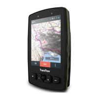
Description of key buttons like LOCK, POWER, BACK, and the Joystick for device operation.
Details on Map controls (zoom, panels), Main Menu, Activity control, Status, and Data bar.
Steps to start an activity by selecting type and finish it by using the Activity control button.
Instructions for setting up a MicroSD card and compatibility with cradle adapters for vehicles.
Manage connection to BLE/ANT+ sensors like heart-rate monitors, cadence, and speed sensors via pairing.
Utilize Land for route planning, Maps for navigation, third-party connections, and TwoNav Link app.
Share position with SeeMe and store/manage activities via GO Cloud, synchronizing with Land software.
Details on the 2-year warranty, exclusions, and conditions for repairs and user-caused damages.
The Aventura 2 is a robust GPS device designed for outdoor navigation and activity tracking, offering a comprehensive suite of features for adventurers and athletes. It serves as a personal navigation assistant, providing real-time location data, mapping capabilities, and performance metrics. The device is built to be user-friendly, with an intuitive interface and various connectivity options to enhance the user experience.
The primary function of the Aventura 2 is to provide accurate GPS navigation. It displays detailed maps, allowing users to follow pre-planned routes, explore new areas, and find their way back to a starting point. The device shows the user's current position on the map, along with relevant data such as distance covered, altitude, and speed. It supports various activity types, from hiking and cycling to running, and can record and store activity data for later analysis.
A key feature is its ability to connect with external sensors via BLE/ANT+™ technology. This allows the Aventura 2 to integrate with heart-rate monitors, cadence sensors, and speed sensors, providing a more complete picture of the user's physical performance during an activity. This sensor integration is crucial for athletes who want to monitor their vital signs and optimize their training.
The Aventura 2 also incorporates advanced communication features, notably "SeeMe." This wireless communication technology enables users to share their position with contacts without relying on a smartphone. This is particularly useful for safety during solo outings, as designated contacts can track the user's progress. In case of an emergency, the device allows users to send a help message to their emergency contact, providing an added layer of security.
Furthermore, the device is part of a broader "TwoNav ecosystem," which extends its functionality beyond just a standalone GPS. This ecosystem includes software like "Land" for PC/Mac, which allows users to create and edit routes, analyze activities, and manage maps. The "GO Cloud" provides a personal storage area for data, enabling users to sync their tracks and activities with the cloud, manage them online, and share them on social media platforms like Strava. The "TwoNav Link" Android/iOS app facilitates communication between the GPS device and a smartphone, offering features such as mobile notifications, file transfers, and syncing with the GO Cloud.
The Aventura 2 also supports connection to third-party services, making it versatile for users who rely on platforms like TraceGPS, UtagawaVTT for routes, or Dropbox, Google Drive for data storage. It can also integrate with workout analysis platforms such as Strava and Training Peaks, allowing users to seamlessly transfer and analyze their performance data.
Getting started with the Aventura 2 involves a straightforward initial boot-up process. Users are advised to charge the device using a 2A charger or higher and connect it to a computer using the provided cable. During the boot-up, users can set up the Wi-Fi connection, which is crucial for updating the TwoNav software and synchronizing data with the GO Cloud.
The device's interface is designed for ease of use, featuring a combination of physical buttons and a touchscreen. The LOCK button allows users to shut down the screen and block buttons, preventing accidental presses. The map display can be toggled between showing tools and a clean view, and a long press enables Pin mode. The full-screen mode hides panels for an unobstructed view of the map.
Navigation through menus is intuitive. The main menu provides access to file management and device settings. Activity control buttons allow users to start, pause, and finish activities. A BACK button serves multiple purposes, acting as a 'back' function in menus and a 're-center' function on the map. Dedicated ZOOM- and ZOOM+ buttons enable quick map scaling. A joystick allows for map movement and menu navigation, with a short press selecting items. The PAGE button cycles through data pages, and a long press brings up the main menu.
The top status bar provides quick access to device status, including sensors and GPS information. A POWER button allows users to turn the GPS on/off with a long press, and a 5-second press forces a shutdown. A re-center button quickly brings the current position back to the center of the map. The data bar displays key metrics, and a contextual menu offers options relevant to the current page.
To start an activity, users go outdoors for a clear sky view, allowing the device to acquire an initial position. They then press the top status bar to check settings like the profile, sensors, and live broadcast. The 'Start' button initiates an activity, prompting the user to select the activity type. During an activity, a brief press on the map can show or hide tools. To conclude an activity, users access the 'Activity control' button in the lower bar and select 'Stop'.
The Aventura 2 is designed with practical maintenance in mind. The back cover can be removed to access the battery compartment and the microSD card slot. While the microSD card is not included, the device supports its use for expanded storage. The manual provides clear instructions on how to open the back cover, insert the battery, and install the microSD card.
For sensor integration, users need to ensure that external sensors are properly installed and activated before pairing. For example, heart-rate monitors might require moistening, and cadence sensors might need the pedals to be turned to activate them. The device's 'Main menu > Settings > Sensors' section allows users to manage these connections.
The TwoNav ecosystem plays a significant role in device maintenance and longevity. Regular updates to the TwoNav software, facilitated by Wi-Fi connectivity, ensure that the device operates with the latest features and improvements. The GO Cloud provides a reliable backup solution for user data, preventing loss of valuable activity records. The "Land" software on PC/Mac also aids in managing maps and routes, ensuring that the device is always loaded with up-to-date and relevant information for planned activities.
The device is manufactured in Spain by COMPEGPS TEAM SL, and users can find support and additional information on twonav.com. The warranty period is 2 years, covering material damage and production defects under normal use. It's important for users to retain their original proof of purchase for warranty claims. The warranty does not cover consumables like batteries, damages from external factors, inadequate use, or unauthorized repairs. Users are also advised to back up their data before sending the device for repair, as files might be deleted during the process. The TwoNav community and technical support are available through support.twonav.com for further assistance, manuals, and troubleshooting.
| Display Resolution | 240 x 320 pixels |
|---|---|
| Battery Life | 20 hours |
| Water Resistance | IPX7 |
| Internal Memory | 4 GB |
| Expandable Memory | microSD up to 32 GB |
| Connectivity | USB, Bluetooth |
| Touchscreen | Yes |
| Barometric Altimeter | Yes |
| Compass | Yes |
| Maps | Topographic maps included |