Do you have a question about the Yamaha ADVENTURE PRO and is the answer not in the manual?
Details FCC RF radiation exposure limits and conditions for use.
Identifies numbered components of the GPS unit and cradle.
Lists and identifies accessories included with the Yamaha Adventure Pro.
Step-by-step guide for attaching the mount, cradle, and harness to the vehicle.
How to power the GPS on and off using the vehicle's ignition and its power management.
Details power-on, manual shutdown, suspend mode, and low battery notifications.
Agreement terms for using the Yamaha Adventure Pro software.
Steps to connect the device to a Wi-Fi network for updates and data.
Option to bypass Wi-Fi connection during initial setup.
Process for adding a new Wi-Fi network manually.
Procedure to remove a saved Wi-Fi network from the device.
How to refresh the list of available Wi-Fi networks.
Instructions for downloading and installing software and map updates via Wi-Fi.
Process for updating the device's main software, including install steps.
Steps to download and install map updates for the device.
Steps to create a user account for saving data and registration.
Instructions for logging into an existing Yamaha Adventure Pro account.
Procedure to reset a forgotten account password via email.
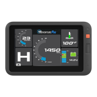
Introduction to the main dashboard screen and its default instruments.
Explains the function and access to the menu bar for software navigation.
Access to Log & Plans for tracking and saved searches.
Functionality to search for trails, tracks, POIs, etc.
Access to the map screen for navigation.
Feature for creating courses and reviewing histories.
Access to account, profile, and connectivity settings.
Describes how vehicle data is displayed on the dashboard instruments.
Instructions on how to customize the displayed dashboard instruments.
Explanation of what the Journal stores: track recordings, waypoints, and searches.
Details about storing tracks, waypoints, and creating trip folders.
Information on storing saved searches and custom routes.
How to sort entries within the Logs and Plans sections.
Information about recorded GPS paths saved in the Log.
How to view map previews and attributes of recorded tracks.
Guidance on how to follow a recorded track from the Log.
Instructions for sharing track data on social networks.
How to convert a recorded track into a course for timing mode.
Options for editing tracks, including adding to trip folders or exporting.
Steps to create a new folder for organizing tracks and waypoints.
How to add existing logs or waypoints into a trip folder.
Method to share organized trip folders.
Process for importing GPX or USR files into the device's Logs.
How to export tracks and waypoints from the Log in GPX format.
Instructions for removing selected entries from the Logs.
Official trail records saved for future use, displayed as orange lines on the map.
Tracks shared by other users, displayed as dashed orange lines.
Routes created on YamahaAdventurePro.com, displayed as dashed purple lines.
How to remove selected entries from the Plans folder.
Overview of available categories for searching locations and points of interest.
How to define the area for search results (Nearby, City, Map, Coordinates).
Steps to search for locations using city names or zip codes.
How to select a specific point on the map to search around.
Procedure for searching based on geographical coordinates.
How search results are displayed in a list format.
How search results are displayed with numbered markers on the map.
Displays detailed information about a search result.
How to save a search result to the Plans folder.
Method to share search results to connected social feeds.
Option to get directions (Go) or follow trails/tracks/routes.
Introduction to the map screen layout and its components.
Information displayed when navigating to a destination.
Controls for recording tracks: Rec/Pause, Backtrack, Finish.
Controls for map interaction: Map Options, Waypoint, Zoom.
How to move the map view around the screen.
Controls for zooming in and out on the map.
How to select a point on the map for details or navigation.
Access to map display settings.
How to toggle between 2D and 3D map perspectives.
Customizing map view with content layers.
Function to mark important locations along a trail or course.
Using predefined options to mark waypoints while moving.
Advanced options for marking waypoints with audio or specific details.
List of predefined waypoint types (Water, Supplies, Obstacle, etc.).
How to record audio notes for waypoints.
Marking a waypoint at the device's current GPS position.
Marking a waypoint by selecting a location on the map.
Marking a waypoint by entering specific geographical coordinates.
Steps to start recording a GPS track.
How to temporarily stop a track recording.
How to continue a paused track recording.
Functionality to navigate back to the starting point of a track.
How to complete and save a recorded track with details.
Steps to enable turn-by-turn street navigation.
Guidance on following trails from search, plans, or map.
Guidance on following tracks from search, plans, or logs.
Steps to follow custom routes created online.
Notifications for upcoming waypoints while navigating.
Alerts when deviating from the planned path and option to continue.
Function to measure driving time, record history, and share data.
Viewing timing measurements and performance from past sessions.
Selecting courses for new timing sessions.
Running and recording a new custom course.
Setting starting and finishing lines for course creation.
Creating courses that automatically detect finish line on return.
Creating one-way courses with a defined finish line.
Adding waypoints to a course for navigation during sessions.
Initiating a new timing session based on a selected course.
Display and tracking of lap times in loop courses.
Tracking attempts made on sprint courses.
How to end and save session data for loop and sprint courses.
Chronological listing and review of recorded sessions.
How to delete recorded session history.
Detailed view of session laps and vehicle performance data.
Exiting the Pro software to access Android apps.
Instructions for checking and installing software, map, and kernel updates.
Synchronizing device data with the YamahaAdventurePro.com account.
Steps to create or manage the user account and profile.
Automatic GPS registration upon account creation.
Logging into an existing account.
Setting up and managing vehicle profiles.
Connecting social media accounts for sharing.
Connecting a Twitter account for direct posting.
Connecting an Instagram account for photo waypoints.
Connecting a Facebook account for posting.
Viewing earned achievement badges for milestones.
Setting preferences for units, coordinates, temperature, brightness, and sounds.
Contact information and resources for technical support.
Customizing map view settings like 2D/3D, orientation, and zoom buttons.
Enabling or disabling street navigation features.
Notifications for service alerts or fault codes.
How to view and clear service alerts and fault codes.
Restored track logs displayed by date.
Instructions for connecting to Wi-Fi networks.
Details on hardware and software model and version numbers.
How to exit the Pro software to access Android apps.
Steps to launch the camera application from the Android menu.
Accessing camera settings to switch modes or adjust parameters.
Options for setting photo/video quality and location saving.
How to capture still images using the device camera.
How to record video clips using the device camera.
Accessing captured media through the Gallery app.
| Battery Life | Not Applicable |
|---|---|
| Type | Not Applicable |
| Engine Type | Not Applicable |
| Displacement | Not Applicable |
| Bore x Stroke | Not Applicable |
| Compression Ratio | Not Applicable |
| Maximum Power | Not Applicable |
| Maximum Torque | Not Applicable |
| Starting System | Not Applicable |
| Fuel System | Not Applicable |
| Lubrication System | Not Applicable |
| Transmission | Not Applicable |
| Clutch | Not Applicable |
| Final Drive | Not Applicable |
| Frame | Not Applicable |
| Front Suspension | Not Applicable |
| Rear Suspension | Not Applicable |
| Front Brake | Not Applicable |
| Rear Brake | Not Applicable |
| Front Tire | Not Applicable |
| Rear Tire | Not Applicable |
| Overall Length | Not Applicable |
| Overall Width | Not Applicable |
| Overall Height | Not Applicable |
| Seat Height | Not Applicable |
| Wheelbase | Not Applicable |
| Ground Clearance | Not Applicable |
| Fuel Tank Capacity | Not Applicable |
| Kerb Weight | Not Applicable |