Do you have a question about the Becker TRAFFIC ASSIST 7977 and is the answer not in the manual?
Warnings about hazardous situations leading to death or serious injury.
Warnings about hazardous situations leading to death or serious injury.
Warnings about hazardous situations leading to minor or moderate injury.
Information regarding unit damage, warranties, or traffic laws.
Provides information regarding the use of the unit.
Critical warnings about safe operation, traffic regulations, and driver distraction.
Notices regarding system limitations, repairs, traffic laws, and accessory use.
Overview of the manual's structure and the devices covered.
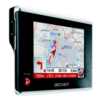
Describes the primary uses of the Traffic Assist device.
Explains the GPS-based navigation capabilities.
Details the MP3 player functionality for listening to music.
Describes the Picture Viewer function for displaying images.
Explains the video player functionality for playing videos.
Introduces Bluetooth connectivity for hands-free phone use.
Instructions for unpacking and checking the device delivery.
Instructions for unpacking and checking the device delivery.
Guidance on how to report any complaints about the unit.
Advice on keeping and disposing of the original packaging.
Details the components and features of the Traffic Assist unit.
Lists the electronic components integrated into the basic unit.
Instructions for connecting the unit to the car's cigarette lighter.
Information about the rechargeable battery and its charging.
Details the use and handling of the SD memory card for maps and data.
Explains how to connect the unit to a PC using the USB cable.
Instructions on mounting the unit in the vehicle using the bracket.
Details the power supply for connecting to a grid outlet.
Information on connecting an external GPS antenna for improved reception.
Details the optional docking station for connecting to audio systems.
Information on connecting headphones for MP3 playback.
Refers to the operating instructions for a comprehensive explanation.
Instructions on how to register the product online for updates.
Guidance on contacting dealers for unit repairs.
Information on emissions, EMC, and disposal can be found.
Lists the items included in the delivery package of the Traffic Assist.
Identifies controls and displays on the front of the unit.
Identifies connection points on the rear of the unit.
Identifies controls and ports on the left side of the unit.
Identifies controls and ports on the right side of the unit.
Details connection points on the left side of the docking station.
Details connection points on the right side of the docking station.
Provides instructions for proper care and maintenance of the unit.
Explains battery capacity decrease and storage effects.
Discusses potential discolored pixels on the display.
Outlines the steps required to start the Traffic Assist unit.
Details map data preinstallation and saving other files.
Step-by-step guide for inserting the memory card.
Step-by-step guide for removing the memory card.
Information on powering the device via car charger or grid adapter.
Details on the internal rechargeable battery.
Instructions for connecting to the public mains grid.
Instructions for connecting the power supply via the car's cigarette lighter.
Information about the integrated GPS antenna and external antenna use.
Guide for connecting an external GPS antenna for better reception.
Instructions for connecting USB memory sticks or hard drives.
Information on the optional docking station's connections.
How to mute car radio for navigation announcements.
Connecting the unit to the audio system for sound output.
Connecting an external microphone to the unit.
Steps to power the Traffic Assist unit on and off.
Instructions for switching the unit off or putting it into sleep mode.
Details on attaching the unit to the windshield with the holder.
Instructions for attaching the unit holder to the windshield.
Specific steps for mounting the unit bracket on the windshield.
Guides for swiveling the support plate horizontally and vertically.
Steps to adjust the carrier plate downwards for viewing angle.
Steps to adjust the carrier plate left to right for viewing angle.
Process for attaching the unit to the bracket via guides and lugs.
Method to detach the unit from the bracket using the clip.
Details about the touchscreen operation and care.
How to interact with touchscreen buttons and invalid selections.
Instructions for recalibrating the touchscreen if it responds imprecisely.
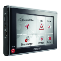
Introduction to the menu structure and applications.
Explains the top-level menu and how applications are started.
How to use the entry menu for inputting data.
Process of pressing keys in the central area to input characters.
How the system suggests entries based on data on the memory card.
How to navigate through selection lists using arrow keys.
Using special characters and umlauts for naming destinations.
How to switch to the numerical keypad for number entry.
How to switch between uppercase and lowercase letters during text entry.
Using the back key to delete the last character entered.
How to insert a space between words in an entry.
Explains the functions of the Becker key for standby and navigation.
Adjusting the volume using the unit's control or application settings.
Information on preinstalled map data and installation from DVD.
Steps to manually start the map installation program.
How to transfer files via memory card or USB port.
Fastest way to transfer files using an SD card reader.
Connecting to a PC via USB for data transfer.
Steps to transfer map data using the installation program.
Storing media files on separate cards or USB media.
How to handle system faults and when to contact a dealer.
Explains the concept of navigation and how GPS works.
Critical warnings about traffic regulations and driver judgment.
Information on the initial startup time for position determination.
How to enter navigation mode from the main menu.
Lists navigation aids: rapid access, navigation menu, map display.
How rapid access starts navigation with saved destinations.
How to access the navigation menu to enter new destinations.
How to view current position and select new destinations from the map.
Explains the layout of the rapid access screen and its keys.
Displays available destinations for quick selection, including home address.
Explains icons used in the destination list for status and type.
Steps to start navigation using an existing destination.
How to start route calculation from saved destinations.
How to scroll through the list of saved destinations.
Options to view or edit saved destinations, including protection.
How to switch to the map display from rapid access.
How to show the current location on the map display.
How to access the extended options of the navigation menu.
How to determine a new destination using the navigation menu.
Overview of the options within the navigation menu.
Steps to select a destination via address entry.
How to select destinations like airports, restaurants, and gas stations.
How to select a destination directly on the map.
How to input geographic coordinates for a destination.
How to plan routes with multiple stopovers.
How to make general navigation settings.
Opening the address selection window from the navigation menu.
How to choose a state or territory from the available list.
Entering the exact destination address details like town and street.
Entering destination town name or postcode, with smart speller.
Using the OK key to transfer selected destinations to the route calculation menu.
Displaying towns matching entered letters and selecting one.
Entering street name and building number, with smart speller.
Transferring the selected street/destination to route calculation.
Displaying streets matching entered letters and selecting one.
Entering an intersecting road to refine destination choice.
Entering a house number to further limit the destination choice.
Options to display destination on map and start navigation.
How to view the entered destination on the surrounding area map.
Setting driving profile to affect route selection and journey times.
How to save a destination with a name for future use.
Steps to initiate navigation and calculate the route.
How to stop the current navigation session.
Selecting points of interest like airports, restaurants, gas stations.
Searching for nearby points of interest based on current GPS location.
Searching for points of interest across the entire country.
Searching for points of interest within a specific town.
Options for POIs: display on map, set profile, save, start route.
Selecting a destination directly from the map display.
Creating and selecting individual routes with multiple destination points.
Selecting stored routes from the system's route list.
How to scroll through the list of saved routes.
Viewing and managing route details like renaming or deleting.
Buttons available for interacting with a loaded route.
Creating a new route by adding destination points.
How to change existing routes in the edit menu.
Calculating route distance and journey time, even without GPS.
Initiating navigation from the route planning menu.
Entering destinations using geographic coordinates.
Accessing navigation-relevant settings.
Overview of buttons available in the settings menu.
Setting drive profile to affect route selection and journey times.
Changing map view settings like 2D/3D display and auto zoom.
Specifying units for time and distance measurements.
Setting additional information to be displayed on the map.
Setting additional information displayed during route guidance.
Displaying speed limits and receiving warnings for exceeding them.
Making settings for traffic announcement reception.
Setting the relevant time zone for arrival time calculations.
Using logical elimination to quickly enter destinations.
Activating aids for complex turning maneuvers at junctions.
Entering, changing, and displaying home address details.
Setting general volume for voice announcements and map display.
Displaying GPS information and saving current location.
Displaying loaded map data from the memory card.
Setting guidance for non-digitized (offroad) areas.
Guidance in offroad areas to digitised roads or nearest roads.
Entering destinations in offroad areas via coordinates or map.
Guidance from offroad start points to nearest digitised street.
Calling up map display from various applications.
How map layout varies by operation mode (driving/no driving).
Map display covering the touchscreen, with toolbar.
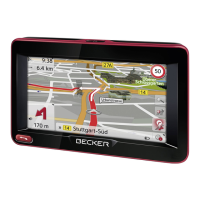
Information displayed during navigation, including speed and next maneuver.
Activating/deactivating the toolbar for map functions.
Using toolbar functions like repeat prompt, volume, and map movement.
Repeating the last navigation announcement.
Adjusting the volume of navigation announcements.
Displaying ETA, journey time, and distance to destination/stopover.
Opening an information window for selected map points.
Using zoom buttons to enlarge or reduce the map view.
Automatically zooming out to display the entire route.
Changing screen display between daytime and night-time modes.
Switching between 2D and 3D map views.
Orienting the map towards north using the compass key.
Displaying available Points of Interest along the route.
Setting a Point of Interest as a stopover for route calculation.
Setting categories for displaying Points of Interest.
Shifting the map in any direction while in move mode.
Accessing the options menu for various functions.
Playing MP3 files while active navigation is in progress.
Accessing the telephone function during navigation.
How to access telephone mode from the main menu or toolbar.
Displays last dialled, answered, or rejected numbers.
Settings for fast access mode, including network and signal display.
Displays numbers/names for fast dialling, with icons and characteristics.
Explains icons used in the number list for entry status.
How to dial an existing number from the list.
Directly dialling numbers/names from the number list.
Navigating the number list using the arrow buttons.
Options to view or edit numbers in fast access mode.
Dialing numbers, opening phone book, and Bluetooth settings.
Entering a phone number and initiating a call or storing it.
Displaying and calling numbers from SIM or phone memory.
Requirements and process for connecting a mobile phone via Bluetooth.
Accessing the device list to search for or connect a mobile phone.
Establishing automatic connection with the last mobile phone after power-on.
Activating Bluetooth and searching for a mobile phone.
Initiating a connection to a mobile phone from the device list.
How to disconnect a connected mobile phone.
Activating Bluetooth, assigning name, setting visibility, and adjusting volume.
Enabling Bluetooth for automatic connection.
Setting whether other devices can recognize the Traffic Assist.
Specifying if connection should be automatic after switching on.
Instructing the unit to transfer phonebook data again.
Adjusting the volume for telephone calls.
Naming the Traffic Assist for display on other Bluetooth devices.
Overview of options for establishing, answering, and ending calls.
Entering a number or selecting from lists to make a call.
How to accept, refuse, or ignore an incoming call.
Terminating a call, depending on whether route guidance is active.
How to call up the music player from the main menu.
Playing MP3 files stored on the memory card.
Key panels arranged around the track line for simplified operations.
Displaying and selecting the next or previous track.
Starting music playback by pressing the play icon.
Pausing and resuming music playback.
Terminating music playback.
Navigating through folders and subfolders to view contents.
Setting continuous track repeat or random playback.
Increasing, decreasing, or muting the music volume.
Starting or continuing navigation while music plays.
Terminating the MP3 player and returning to the main menu.
How to call up the picture viewer from the main menu.
Calling up and displaying images stored on the memory card.
Key panels for simplifying picture viewing operations.
Moving between pictures at the current folder level.
Automatically displaying all pictures from the current folder.
Enlarging the current picture to fill the entire touchscreen.
Closing the Picture Viewer and returning to the main menu.
Displaying the picture viewer's folder level in a key panel.
Navigating and viewing contents of folders and subfolders.
Loading a picture directly into the Picture Viewer from the list.
Moving to the next highest folder level or displaying subfolder contents.
Closing the folder overview.
How to call up the video player from the main menu.
Playing videos stored on the memory card, supporting MPEG1 and WMV.
Opening and playing videos using the player interface.
Displaying or hiding the video player's button bar.
Pausing and continuing video playback.
Using buttons for fast forwarding or reversing video playback.
Adjusting the volume for video playback, including mute functionality.
Pre-selecting basic settings for all Traffic Assist applications.
Overview of available setting possibilities.
How to choose selections and navigate pages within the settings.
Details of specific settings like Energy, Brightness, Calibration, Language.
Information on power supply and visualization of energy status.
Changing the screen display between daytime and night-time modes.
Instructions for recalibrating the touchscreen if it responds imprecisely.
Initiating the touchscreen calibration process.
Displaying touch-screen text in various languages.
Accessing the language selection menu.
Switching the side light bars on/off or changing their color.
Switching Traffic Assist signal tones on or off.
Automatically switching the unit to sleep mode when ignition is off.
Enabling or disabling the automatic on/off function.
Displaying product designation and software version details.
Resetting the unit to factory defaults, clearing data.
Defining whether audio signal/microphone output is via internal speakers.
Standard synchronization software for Windows mobile units.
Technology for short-distance wireless data transmission.
Greenwich Mean Time, used for data synchronization.
Global Positioning System for determining geographical position using satellites.
Horizontal Dilution Of Precision, indicating positional determination quality.
"Index of Contents" for MP3 titles, containing metadata.
Joint Photographic Experts Group, a common image storage format.
A re-writable storage card, in this case an SD card.
Special compression process for audio data like music.
File on CD/storage card/microdrive containing MPS titles.
Secure Digital Card, a re-writable storage card.
An input pointer used for operating touch-screens.
Universal Serial Bus, a system for computer peripheral interconnection.
Physical size of the unit in millimeters.
The weight of the Traffic Assist unit in grams.
Details about the unit's processor.
Specifications of the touch-screen display.
Information on internal Flash and SD-RAM storage.
Specifications for the SD card reader, including capacity and format.
Details on the USB interface types supported.
Specification for the headphone socket.
Information on the unit's internal speaker power.
Voltage requirement for power supply via USB connection.
Specifications for the AC adapter, including voltage and current.
Compliance statement with FCC rules regarding interference.
Australian and New Zealand certification trademarks.
Conformance to EC guidelines and electromagnetic compatibility specifications.
Declaration of conformity with EU guidelines and R&TTE Directive.
Customer information on disposing of electrical and electronic devices.
| Device Category | GPS |
|---|---|
| Manufacturer | Becker |
| Model | TRAFFIC ASSIST 7977 |
| Touchscreen | Yes |
| Resolution | 480 x 272 pixels |
| Internal Memory | 2 GB |
| Card Reader | SD card |
| Bluetooth | Yes |
| TMC | Yes |
| Processor | 400 MHz |
| GPS Receiver | SiRFstarIII |
| Speed Camera Alerts | Yes |
| Battery | Lithium-Ion |
| Traffic Information | TMC |
| Display Size | 4.3 inches |
| Maps | Pre-installed |