Do you have a question about the Geonav 7 Wide and is the answer not in the manual?
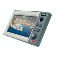
Lists the main features and functions of the GEONAV unit.
Details the power supply and consumption specifications.
Essential precautions for avoiding interference and ensuring proper unit use.
Instructions for cleaning the display and mounting the unit.
Explanation of the 10-pin connector and NMEA 0183 data connections.
Important warnings regarding the use and handling of CompactFlash cartridges.
Explanation of ZOOM buttons and the multi-directional joystick.
Details on the ENT (ENTER) and GOTO buttons and their operations.
How to access and use the diagnostic program for system checks.
How to enable or disable the display of chart boundaries.
Adjusting chart scale and converting depth measurements between units.
Understanding markers, track segments, and boat's position indicators.
How to power the unit, use the welcome page, and interface with a depth sounder.
Explanation of the automatic navigation mode and its features.
Using cursor mode and enabling/disabling chart rotation for better orientation.
Activating Autozoom for optimal scale and Screen Amplifier for chart redraw.
How to use EBL and VRM to enter markers and waypoints.
Manually correcting GPS position errors for improved accuracy.
Adjusting screen brightness and selecting track/marker colors.
Starting the unit, loading charts, and basic navigation mode operations.
Details on planning and editing routes within Cursor Mode.
Details shown in Navigation Window with and without an active route.
Details on boat speed, VMG, wind angle, and route tracking.
How the Depth Sounder window displays seabed and water temperature.
Displaying trip speed, distance, and resetting trip counters.
How the Satellite Window displays tracked satellites and signal strength.
Viewing detailed tide and current data, including warning on graph accuracy.
Details on target waypoint data and the runway graph.
Enabling the 3D view and controlling angle, zoom, and detail level.
Enabling split windows and switching between 2D and 3D views.
Understanding sonar technology and signal representation in the Fishfinder window.
Adjusting scanning speed, pulse parameters, and operating modes.
Adjusting depth range, overall sensitivity, and limits.
Enabling and configuring fish, shallow, and depth alarms.
Using simulation, restoring settings, and checking software version.
Enabling, using, and disabling the MOB function for overboard incidents.
Using GEONAV to control an autopilot for automatic route navigation.
| Resolution | 800 x 480 pixels |
|---|---|
| GPS Receiver | Yes |
| Waterproof Rating | IPX7 |
| Type | Chartplotter |
| NMEA 2000 Compatible | Yes |
| Wi-Fi | No |
| Bluetooth | No |
| Display Size | 7 inches |
| Sonar Compatible | Yes |