Do you have a question about the Geonav 11 Sun and is the answer not in the manual?
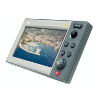
Lists general features and capabilities of the GEONAV unit.
Details screen types, power requirements, and electrical specifications.
Outlines memory capacity and interface standards like NMEA.
Essential safety and operational guidelines for installation.
Instructions for cleaning the unit and mounting it on a panel.
Step-by-step guide for flush mounting the GEONAV.
Instructions for mounting the GEONAV using a bracket.
Details pin assignments for power supply and data connections.
Explains NMEA 0183/2000 and auxiliary data input/output connections.
Procedures for inserting and removing CompactFlash cards.
Explains the use of the joystick and zoom keys for chart navigation.
Details functions of keys like MARK, GOTO, CLR, PAGE, PWR for operations.
Information on chart content, geographic names, and contour display.
Details on displaying port services and tidal/current information.
Explains visual elements like markers, tracks, and boat position on the chart.
Covers switching the unit on/off, welcome page, and mode selection.
Details on Autozoom, Screen Amplifier, EBL/VRM, and Easy Pilot functions.
Explains Overzoom, position calibration, and display settings.
Steps for plotting routes and navigating between waypoints.
How to use the cursor for route planning and editing.
Automatic mode for displaying boat position and navigation data.
Procedures for creating, editing, and deleting routes and waypoints.
How to view detailed route information and waypoint coordinates.
Saving routes to CompactFlash and loading them back into the unit.
How to initiate and end track recording sessions.
Saving recorded tracks to CompactFlash and loading them.
Managing track segment data, colors, and display options.
How to add new markers and modify existing ones with details.
Saving marker sets to CompactFlash and loading them.
Procedures for removing individual markers or entire marker sets.
Configuration options available in the GEONAV's Standard mode.
Configuration options available in the GEONAV's Advanced mode.
How to set a destination waypoint or navigate to a specific port.
Navigating to markers and nearest services based on user selection.
Accessing tide and current data for specific survey stations.
| Type | Chartplotter |
|---|---|
| GPS | Yes |
| Radar Compatibility | Yes |
| Sonar Compatibility | Yes |
| Display Type | LCD |
| Power Supply | 12V/24V DC |