Do you have a question about the GeoSlam ZEB Horizon and is the answer not in the manual?
Details key specifications like maximum range, field of view, scan rate, and weight.
Lists part numbers and their corresponding descriptions for the ZEB Horizon system.
Details battery output voltage, capacity, charge voltage, weight, and life cycle.
Provides instructions on connecting the charger and recognizing charging status via LED indicators.
Explains how to check battery percentage and predicted run-time on the display.
Advises against improper disposal, dismantling, short-circuiting, and recommends storage and charging practices.
Outlines compliance with UN Manual of Tests and Criteria for air transportation.
Emphasizes using trained operators, proper handling, and avoiding modifications to the equipment.
Identifies the laser scanner as Class 1 and safe under normal operating conditions.
Lists compliance standards for electromagnetic compatibility and FCC rules.
Reiterates key battery safety measures like not dismantling or short-circuiting.
Guides on proper disposal according to WEEE directive and return options.
Provides contact details for GeoSLAM support via phone and email for assistance.
Explains the combination of LIDAR and IMU data processed by GeoSLAM's SLAM algorithm.
Discusses the importance of environmental features for SLAM algorithm accuracy and handling feature-poor areas.
Explains the necessity of closing survey loops to minimize error and improve point cloud accuracy.
Provides guidance on moving through doorways and tight bends to maintain SLAM accuracy.
Recommends maintaining a walking pace for good data coverage and SLAM processing.
Details the scanner's range capabilities and advises on optimal scanning distances.
Suggests limiting scan missions to 30 minutes to manage file size and drift.
Offers techniques for scanning in challenging or confined spaces.
Advises on the impact of moving objects on SLAM accuracy and best practices.
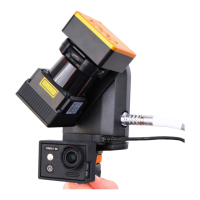
Instructions for physically connecting the scanner head to the datalogger.
Details how to attach the reference base plate to the ZEB Horizon scanner.
Emphasizes planning and following guidelines before starting data collection.
Provides the correct procedure for powering down the ZEB Horizon datalogger.
Explains the meaning of different LED indications on the data logger and scan head.
Lists specific LED error patterns and their corresponding causes.
Details how to connect and transfer data using an Ethernet cable and Windows File Explorer.
Explains the process of transferring data to a USB storage device using the datalogger's USB port.
Introduces the GeoSLAM Connect software for processing raw scan data into a 3D point cloud.
Describes the USB Prepare tool for basic interaction with the datalogger, like file transfer and time settings.
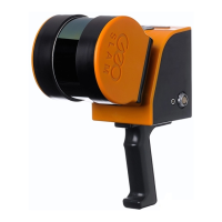
Provides detailed physical dimensions and mounting information for the ZEB Horizon.
Contains the certificate confirming the battery meets air transport safety regulations.
| Range | 100 m |
|---|---|
| Battery Life | 4 hours |
| Laser Class | Class 1 |
| Field of View | 360° horizontal, 270° vertical |
| IP Rating | IP54 |
| Data Output | LAS, PLY, E57, XYZ |
| Scanning Speed | Up to 300, 000 points per second |
| Data Storage | 128 GB |
| Software | GeoSLAM Draw |
| Type | Handheld Laser Scanner |