Do you have a question about the Haglof Vertex Laser Geo and is the answer not in the manual?
Background information on Haglöf Sweden AB and its focus on measurement solutions.
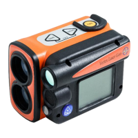
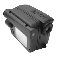
Introduction to the Vertex Laser Geo and Laser Geo instrument models.
Highlights the capacity, versatility, and measurement capabilities of the GEO instruments.
Details the built-in GPS receiver for tagging data with coordinates and mapping.
Explains the suitability of VERTEX LASER GEO for forestry measurements using ultrasound.
Covers standard height measuring functions with laser and ultrasound.
Information on firmware upgrades, Bluetooth, and battery charging.
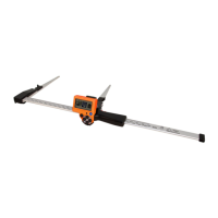
Detailed breakdown of the GEO instrument's parts, including optics, display, buttons, and sensors.
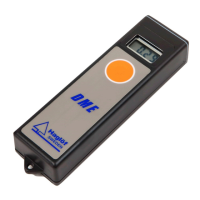
Description of the T3 transponder, its function, and battery requirements.
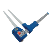
Details accessories for circular plot work and plot center staff usage.
Information on the optional monopod for steady aiming and measurements.
Covers the ON, Arrow, DME, and SEND buttons for instrument control and data management.
Explains EXIT, RESET, and manual TURN OFF procedures for the instrument.
Details the red dot sight and heads-up display for aiming and viewing results.
Covers battery status, charging, and operational life of the instrument.
Explains the main screen layout and interpretation of status icons.
Covers settings for units (metric/feet, deg/grad/%), and pivot offset.
Details setting the transponder height (TRP.HGT) for accurate measurements.
Configures eye height (EYE HGT) and manual distance input (M.DIST).
Sets laser targeting modes and configures the Basal Area Factor (BAF).
Enables compass use and explains setting magnetic declination for accurate readings.
Provides city-specific magnetic declination values for reference.
Sets the unit for compass display (degrees or grades).
Explains laser distance measurement principles and target selection.
Details ultrasound distance measurement with T3 transponder and BAF function.
Step-by-step guide for measuring height using three laser points.
Procedure for measuring height using a single laser point and eye height.
Guide for measuring height using ultrasound and a transponder.
Procedure for height measurement using manual distance input.
Details CSV and KML file formats for trail data export and visualization.
Illustrates trail data visualization in Google Earth using KML files.
Using DME for baseline measurement, especially when vegetation obstructs laser.
Presents summary data like area and circumference for measured targets.
Shows KML file examples for visualizing map target data in Google Earth.
Introduction to freeware for analyzing target data (area, volume).
Details the compass function, accuracy, and potential interference factors.
Steps for measuring azimuth using laser or DME with the compass.
Procedure for measuring general angles and inclination of slopes.
Measuring horizontal distance using ultrasound and a transponder.
Estimates height difference between a line and a third point (e.g., power line sag).
Procedure for measuring distance using ultrasound and the T3 transponder.
Steps to calibrate the ultrasound for maximum accuracy.
Explains BAF for relascope measurements and diameter calculation.
Details using the laser function for BAF calculations.
Details the GEO's GPS capabilities and how to enable it.
Step-by-step guide to activating the instrument's GPS.
Configuring the instrument to send GPS data to other units.
Information on obtaining a stable GPS position and signal.
Procedure for measuring an area using the built-in or external GPS.
Details the location and format of GPS data files.
Demonstrates viewing measurement data in Google Earth.
How to adjust the display contrast for better visibility.
Overview of saving data and memory capacity.
Activates the instrument's memory to store measurement data.
Procedures to delete all data from the instrument's memory.
Displays information on the instrument's memory usage.
Transfers stored files wirelessly to external devices using BLE.
Steps to connect the instrument to a PC via USB for data access.
Defines all fields available in the CSV data output.
Provides examples of formatted CSV data for different measurements.
Guides on activating and connecting via Bluetooth for data transfer.
Details on using IR for data transfer to specific Haglöf calipers.
Describes the structure of data packets sent via IR.
Explains the NMEA format used for Bluetooth data transmission.
Procedure to recalibrate the instrument's compass for accuracy.
Steps to test the compass accuracy after calibration or use.
Details dimensions, weight, materials, power, and battery specs.
Covers buttons, display, Bluetooth, IR, sight, memory capacity and type.
Specifies ranges and resolutions for height, vertical angle, and horizontal angle.
Lists minimum/maximum range, accuracy, and modes for laser.
Defines the X, Y, Z axes and directions used by the instrument.
Details GPS systems, features, and NMEA message protocols.
Provides details on GPS receiver sensitivity, accuracy, and start times.
Lists specifications for ultrasound and the T3 transponder.
Details specifications for adapters, monopods, and carrying cases.
Lists symptoms and check points for ultrasound measurement errors.
Identifies causes and solutions for incorrect compass azimuth results.
Outlines the limited warranty terms and service procedures.
Essential safety guidelines and warnings for instrument usage.
Instructions for cleaning, storing, and maintaining the instrument.
Important notes and precautions for handling instrument batteries.
| Brand | Haglof |
|---|---|
| Model | Vertex Laser Geo |
| Category | Measuring Instruments |
| Language | English |