Do you have a question about the Haiyang Stella Series and is the answer not in the manual?
| Brand | Haiyang |
|---|---|
| Model | Stella Series |
| Category | Automobile Accessories |
| Language | English |
Keep manual in a safe place for quick access.
Understand GPS operation and electronic chart responsibility.
Explanation of visual symbols used for safety instructions.
Warnings about high voltage, electrical shock, and not disassembling components.
Caution regarding liquid content in LCD and avoiding mechanical shock.
Importance of adequate ventilation to prevent overheating.
Guidelines for secure mounting and using correct materials.
Safety precautions for internal inspection, capacitor discharge, and ESD avoidance.
Guidance on data backup, transducer use, and transducer cleaning.
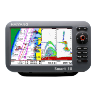
Introduction to Stella series navigation system display and management features.
Device is an aid to navigation; resolve uncertainty with other sources.
Procedure for handling contact with LCD display module liquid.
No direct relation between water color and depth; use official charts.
Protect the display from direct sunlight to prevent degradation.
Explanation of symbols (*) and (#) used in documentation.
Description of keys for menu navigation, scale adjustment, and system functions.
Key functions for combined Chartplotter and Fishfinder operation.
Details on keys for navigation, track management, and settings.
Instructions for turning on/off, restarting, and adjusting brightness/modes.
How to lock touch screen, use Wi-Fi/Bluetooth, and access data layout.
Accessing data layout, Sky Mate, and web browser functions.
Details of pins for CAMERA1, CAMERA2, POWER, TD, AIS, NMEA connectors.
Pin configurations for TD, CAMERA1, and PWR/IO plastic connectors.
Explanation of icons for vessel, cursor, AIS, databar, and WPT information.
Description of palette, depth bar, frequency, LF/HF info, and databar.
Display format for primary navigation data including LAT/LON, SOG, COG.
Display format for secondary navigation data with more details.
Explanation of WPT name, direction of steer, WPT icon, vessel, and range.
Description of WPT name, direction of steer, and WPT icon.
Explanation of receiver status, satellite positions, SNB graph, and navigation data.
Overview of GPS, HY, HY2, and customizing modes for databar display.
Steps to edit or customize the databar content.
Options for selecting databar frames and setting up content in each box.
Setting databar visibility and position on screen.
How to activate and navigate the cursor on the chart.
Detailed instructions for moving the cursor in various directions.
Explanation of latitude/longitude, range, and bearing in the cursor window.
Standard and Flip modes for choosing and arranging display pages.
Steps to move and customize page layouts using the red box.
Selecting frames and pages using navigation keys for layout customization.
Using long press to drag and drop pages for layout customization.
How pressing [FUNC] changes key functions to chartplotter or fishfinder.
Selecting between two types of navigation data display formats.
Procedure for editing navigation data fields on the display.
How to activate, exit, and remove MOB markers.
Guidance on inserting memory cards and USB OTG devices.
Instructions for saving WPT, Route, and Track data to external media.
How to save user lines and user names to SD/Micro SD/USB.
Procedure for loading saved user data from external media.
Methods for loading WPT, Route, and Track data from SD/MicroSD/USB.
Procedures for loading user lines and user names from storage.
Setting GOTO by creating a route simultaneously.
Directly setting a destination for GOTO navigation.
Accessing the list to edit, create, erase, and navigate waypoints.
Choosing custom symbols for waypoints.
Selecting custom colors for waypoints.
Adding waypoints via the list or by direct chart input.
Removing waypoints from the list or directly from the chart.
Options for erasing all or specific waypoints by symbol/color.
Procedure to reposition existing waypoints.
Initiating navigation to a selected waypoint from the list or chart.
Repositioning waypoints relative to the vessel's current position.
Instructions for moving a waypoint to the vessel's current location.
Organizing the waypoint list based on various criteria.
Select a waypoint and edit its details.
Accessing the route list to view route name, WPT count, distance, and display settings.
Detailed view of waypoints within a route, including LAT/LON, depth, and range.
Two methods for creating routes: using GOTO or adding from the route list.
Choosing a route from the list to edit its details.
Methods for incorporating existing or new waypoints into a route.
Starting navigation for a route and removing waypoints from it.
Configuring track recording based on time or distance intervals.
Adjusting visual properties of the track display.
Selecting colors for different track points.
Procedures for erasing track data by color.
Methods to erase all track data or specific segments using a cursor.
Using the chart to define the start and end of track data to be erased.
Managing track data in rooms using index selection and list view.
Information on track rooms, points, color, and erasing functionality.
How to measure distance and bearing between two points using the cursor.
Drawing custom lines on the chart with start and end points.
Inputting custom place names directly onto the chart.
Procedure for correcting chart position errors using the offset function.
Setting the map to move over a stationary vessel icon.
Keeping the vessel position fixed while the map moves underneath.
Orienting the map based on the vessel's course.
Orienting the map with the vessel's heading pointing upwards.
Selecting map orientation modes and showing/hiding user data.
Configuring info display and adjusting map scale.
Choosing color palettes (Normal, Sunlight, NOAA) for screen visibility.
Adjusting chart latitude and longitude for accuracy.
Settings for depth lines, rocks, fishing banks, land color, etc. on HY-MAP.
Overlaying satellite images and adjusting font/symbol sizes.
Configuring map drawing levels and chart boundary display.
Selecting the display language for place names and lighthouses.
Adjusting the size of the vessel icon and the length of the heading line.
Selecting vessel symbol style and setting orientation resolution.
Choosing between crosshair and arrow cursor icons.
Setting alarms for arrival at waypoint and cross-track error.
Configuring anchor alarms and periodic interval alarms.
Setting alarms for user lines and their range.
Explanation of Automatic Identification System and its benefits.
Key terms and definitions related to AIS targets and alarms.
How to access and view detailed information about selected AIS targets.
Accessing summarized AIS data for targets on the chart.
Controlling AIS display and viewing the list of AIS targets.
Accessing comprehensive data for a selected AIS target.
Using the Goto function to navigate towards an AIS target.
Enabling range rings around the current position for AIS targets.
Options for sorting the AIS target list.
Customizing the size and color of AIS targets on the chart.
Filtering AIS transmissions by vessel type.
Setting up alarms for Closest Point of Approach and Time to CPA.
Configuring ranges for AIS alarms and ignoring slow vessels.
Customizing the display of the own vessel's AIS target.
Managing AIS messages, including SART alerts.
Setting up and alarming for fishing net AIS targets.
Configuring fishing net alarm range and AIS target display scale.
Adding, erasing, and customizing vessel symbols/colors for group fishing.
Selecting between dual frequencies for fishfinder operation.
Adjusting gain and sensitivity time control (STC) settings.
Methods for fine-tuning gain and STC for optimal display.
Overview of Normal, Bottom-lock, Bottom-zoom, and A-scope modes.
Magnifying the sounder display from the sea bottom towards the surface.
Dividing screen for bottom relative view and magnifying for echoes.
Showing an enlarged fishfinder screen for a set range.
Measuring depth by aligning a movable marker with targets.
Scrolling through past fishfinder screens using navigation keys.
Accessing the fishfinder menu and userdata settings.
Adjusting depth range and sea bottom detail view (shift).
Configuring interference and noise rejection levels.
Configuring A-scope, image speed, and white line settings.
Adjusting font sizes, showing temperature, and frequency display.
Configuring fish symbols and their size display.
Adjusting color levels and rejection for fishfinder display.
Selecting background color and adjusting transducer output power.
Configuring deep/shallow depth and low/high temperature alarms.
Setting alarms, depth, and range for fish-school detection.
Choosing transducer pulse and correcting water temperature readings.
Adjusting boat speed value tolerance based on source.
Correcting depth tolerance and setting TD frequency.
Choosing between internal sensor or NMEA for speed source.
Setting coordinate system (GPS/Loran) and datum (WGS-84).
Adjusting latitude and longitude for signal error correction.
Applying filters to optimize vessel movement data.
Selecting units for Lat/Lon and choosing receiver port.
Configuring units for distance, speed, and depth measurement.
Setting temperature units and calibrating the compass.
Customizing time, date, and month format preferences.
Setting the first day of the week and configuring NMEA output sentences.
Selecting and enabling/disabling NMEA data fields.
Adjusting transmit speed and controlling the buzzer function.
Setting screen sleep mode and accessing customization options.
Configuring databar visibility, position, and editability.
Selecting navigation data types and customizing menu colors.
Controlling the visibility of WPT info and cursor windows.
Customizing symbols and colors for waypoints and tracks.
Setting track colors and choosing selection methods.
Choosing between Standard and Flip modes for page display.
Checking system versions for maintenance and upgrades.
Using the simulator for demonstrations and selecting the system language.
Configuring remote control and system initialization options.
Configuring the IP address for wire LAN connection.
Accessing calendar features and saving screen captures.
Managing captured files and saving user settings.
Setting data layout visibility and moving layout elements on the screen.
Configuring data layouts for GPS, Time/Date, and Userdata.
Setting data layouts for Fishfinder and unspecified data (Voltage).
Details on display, resolution, power, temperature, and options.
Information on GNSS capabilities, channels, accuracy, and sensitivity.
Specs for display method, mode, latitude limits, map scale, waypoints, and routes.
List of included accessories like display unit, cables, and brackets.
Details on display, GPS capabilities, and system options for ST-1212CF.
Specifications for chartplotter and fishfinder display settings.
Specifications for frequency, output power, and operating range.
List of standard accessories for the ST-1212CF unit.
Details on display, resolution, power, temperature, and options for ST-1010C.
Information on GNSS capabilities, channels, accuracy, and sensitivity.
Specs for display method, mode, latitude limits, map scale, waypoints, and routes.
List of included accessories for the ST-1010C unit.
Details on display, GPS capabilities, and system options for ST-1010CF.
Specifications for chartplotter and fishfinder display settings.
Specifications for frequency, output power, and operating range.
List of standard accessories for the ST-1010CF unit.
Explanation of customizing items related to position, speed, and time.
Definitions for waypoint, depth, temperature, and voltage customizing items.
Explanations for ETA, XTE, WPT range, bearing, and info customizing items.
Descriptions of icons for anchor berths, beacons, navigation areas, and fog signals.
Icons for wrecks, lighthouses, restricted areas, and marine farms.
Descriptions of various buoy types, oil tanks, and port information.
Criteria for choosing an optimal location for the display unit.
Step-by-step guide for securely mounting the display unit.
Diagram and dimensions for mounting bracket installation.
Diagram and dimensions for flush mounting the display unit.
Instructions for connecting the power cable to the unit.
Guidelines for cleaning and maintaining the display unit.
Introduction to NMEA 0183 standard for marine data communication.
List of NMEA data sentences used by the HGP-660.
Recommendations for installing the GPS antenna at the highest point for best signal.
Instructions for positioning the GPS antenna away from interference sources.
Specific distances required from other antennas, radar, and metal surfaces.
Explanation of the GPS satellite system and its orbiting nature.
How GPS uses satellite signals for position determination.
Process of satellites transmitting orbital data to the GPS receiver.
How the receiver calculates distances and fixes position by triangulation.
How satellite distribution in the sky impacts position accuracy.
Definition of HDOP and its relation to position accuracy.
Need for transducer installation with sonar option and skill requirements.
Caution regarding drilling holes and ensuring water integrity.
Recommendations for transom mounted transducers, avoiding inboard engines.
Advice on cleaning transducers and using antifouling paint.
When to use through-hull transducers and model selection.
Choosing locations free of bubbles and disturbed water flow.
Mounting considerations based on hull dead-rise and use of fairing blocks.
Coating transducers with antifouling paint to maintain performance.
Details on power cable connectors, wire colors, and dimensions.
Information on data cable connectors, pin assignments, and dimensions.
Pinout for power cable and I/O connector, including wire colors and functions.
Diagram and model number for the GPS antenna.
Pin assignments and model number for the TDSS502M transducer.
Pin assignments and model number for the TDSS502P transducer.
Details on the one-year warranty for the main unit and accessories.
Conditions not covered by the warranty, such as user carelessness or unauthorized modifications.
