Do you have a question about the Humminbird 1197c SI Combo and is the answer not in the manual?
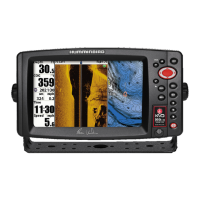
Lists and explains the functions of the control panel buttons like ZOOM, VIEW, INFO, MENU, MARK, EXIT, GOTO.
Describes the procedure for turning the unit on using the power button.
Details methods for cycling through and selecting chart and sounder screen layouts using the VIEW button or shortcut.
Describes how to initiate navigation to a waypoint using the GOTO key or cursor.
Details accessing the waypoint list and options through the menu system.
Explains methods for marking new waypoints using the MARK button or menu.
Covers modifying waypoint details and ending an active navigation session.
Details how to switch the chart display between 'course-up' and 'north-up' modes.
Instructions for safely shutting down the GPS/chartplotter unit.
| Display Type | Color TFT |
|---|---|
| GPS | Yes |
| Weight | 7.8 lbs |
| Target Separation | 2.5 inches |
| Power Output | 500 Watts (RMS) / 4000 Watts (Peak to Peak) |
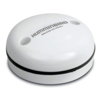
| GPS Receiver | Internal |
| Waypoints | 3000 |
| Routes | 50 |
| Temperature Sensor | Yes |
| Speed Sensor | Yes |
| Compass | Yes |
| Power Input | 10-20 VDC |
| Display Size | 10.4 inches |
| Sonar Frequency | 50/200/455/800 kHz |
| Sonar Type | Side Imaging, Down Imaging |
| Depth Capability | 1500 feet |
| Frequency | 50/200/455/800 kHz |
| Memory Card Slot | Yes |
| Track Logs | 50 Tracks/20, 000 Points |
| Operating Temperature | -15°C to 55°C |