Do you have a question about the Rand McNally intelliroute TND 520 LM and is the answer not in the manual?
| Brand | Rand McNally |
|---|---|
| Model | intelliroute TND 520 LM |
| Category | GPS |
| Language | English |
Covers critical safety guidelines for navigation, installation, and device handling.
Lists all components provided with the Rand McNally IntelliRoute® TND™.
Instructions and recommendations for charging the device's battery.
Step-by-step guide for securely mounting the device.
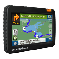
Details device components, ports, buttons, and the initial startup procedure.
Explains the icons and functions available on the Main Menu screen.
Configuration options for general device operation and display.
Settings related to truck-specific information and warnings.
Customizing various audible and visual warning alerts.
Options for customizing route calculation and navigation behavior.
Settings for map display, icons, and zoom behavior.
Inputting and configuring truck-specific details like weight, height, and hazmat type.
Setting distances for curve, hill, and engine brake warnings.
Configuring warnings for crossing borders, tolls, weigh stations, and construction areas.
Customizing map icons for address books, truck, and route colors.
Adjusting vehicle type, time zones, driver status, and map color modes.
Configuring screen interaction, keyboard layout, voice, language, units, and clock.
Fine-tuning route settings like turn announcements, ETA adjustments, and avoiding road types.
Adjusting map zoom, POI icon visibility, and vehicle icon appearance.
Overview of methods to enter destinations: New Location, History, Address Book, POIs, and Local Search.
Tips for efficient address entry, including auto-complete, city/street search, and special route entry.
Guides for routing to addresses, city centers, intersections, and by latitude/longitude.
Step-by-step instructions for searching and selecting addresses for routing.
Specific steps for routing to city centers and street intersections.
Instructions on how to route to a location using geographic coordinates.
How to add, sort, and route to saved locations in the Address Book.
Creating and managing groups for organized address book entries.
Creating, adding stops to, and removing stops from multi-stop trips.
Options for automatically optimizing or manually reordering stops in a trip.
Instructions for selecting, running, and deleting saved multi-stop trips.
Using map taps to add via points, avoid locations, set origin, or route directly.
Configuring the device's home location for quick routing.
Overview of POI search types: near truck, city, route, destination, or custom POIs.
Selecting specific POI categories like Travel Centers, Truck Services, and filtering by amenities.
How to search for non-truck related points of interest like restaurants or hospitals.
Filtering travel centers and truck services by amenities and rating POIs.
Using Wi-Fi to search for businesses and locations by name, keyword, or category.
Details on the options available in destination confirmation screens.
How to view and select between two calculated routes.
Explanation of the main map display elements and navigation tools.
Displaying and routing to points of interest and amenities at upcoming exits.
Customizing route views and reviewing trip details like distance, time, and legs.
Detailed explanation of the Virtual Dashboard's displays and data.
How to manually or automatically reset trip data like odometer and timers.
Understanding the Junction View screen for upcoming maneuvers and lane guidance.
Managing route options, detours, saving current location, and accessing the Avoid List.
Steps for connecting to Wi-Fi hotspots for internet features.
Accessing and viewing current weather, forecasts, and weather overlays.
Viewing fuel station prices, filtering by type, and sorting by distance or price.
Accessing key truck-specific tools like Info, Timers, Warnings, and Quick Planner.
Tracking driving sessions, maintenance timers, and odometer readings.
Recording and viewing mileage logs by quarter, year, date, state, or load status.
Using the Trails feature to record and display GPS paths traveled.
Recording fuel purchases, viewing logs by quarter, state, or month, and calculating economy.
Estimating mileage, driving time, and cost between two cities or towns.
Accessing Rand McNally's Motor Carriers' Road Atlas for emergency and phone numbers.
Using tools for unit conversion, calculations, scheduling, and note-taking.
Utilizing real-time traffic information for route adjustments and incident alerts.
Interpreting various icons used to represent traffic conditions and events.
Using the Dock software for upgrades, map updates, and feature access.
Uploading and formatting custom points of interest for the device.
Step-by-step guide to loading custom POI files using the Rand McNally Dock.
Exporting mileage and fuel data to a computer via the Rand McNally Dock.
Using the Tell Rand feature to send messages about construction, suggestions, or issues.
Links to Rand McNally website, support, accessories, dock, and demo videos.