EasyManua.ls Logo

Rand McNally TND Tablet 70 User Manual

Rand McNally TND Tablet 70
70 pages
To Next Page IconTo Next Page
Page #1 background imageLoading...
Page #1 background image
Question and Answer IconNeed help?

Do you have a question about the Rand McNally TND Tablet 70 and is the answer not in the manual?

Rand McNally TND Tablet 70 Specifications

General IconGeneral
Display Size7 inches
Resolution1024 x 600 pixels
Processor1.3 GHz Quad-Core
RAM1 GB
Storage8 GB
Operating SystemAndroid
GPSYes
BluetoothYes
Wi-Fi802.11 b/g/n
Expandable StoragemicroSD up to 32 GB
BatteryRechargeable lithium-ion
Dimensions7.5 x 4.7 x 0.5 inches

Summary

About GPS and Customer Support

Customer Support Contact Information

Contact details for customer support via phone and email, including service hours.

Your Device: Setup and Safety

Important Safety Information

Critical safety precautions for device navigation, operation, and handling.

Device and Installation Safety Guidelines

Safety guidelines for device handling, mounting, and cable installation.

Your Device: Package Contents and Installation

Installing the Mount

Step-by-step instructions for properly mounting the device.

Your Device: Hardware Overview

Getting Started: Initial Setup Procedures

Connecting to Wi-Fi

Instructions for connecting the tablet to a wireless network for internet access.

Getting Started: Quick Settings Access

Getting Started: Advanced Settings

Truck GPS Application Usage Notes

Notes on Truck GPS Usage

Important usage notes for the Truck GPS app, including Wi-Fi requirements.

Truck GPS: Main Menu Details

Intelli RouteĀ® Main Menu Functions

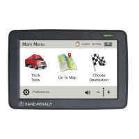
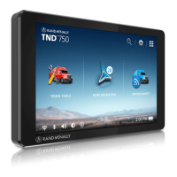
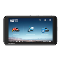
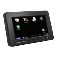
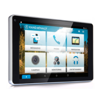
Detailed explanation of each main menu item and its purpose.

Device Settings: General and Route Preferences

Route Calculation Preferences

Options to fine-tune route calculation and preferences.

Device Settings: Truck Information Setup

Truck Information Configuration

Configuring truck dimensions, weight, and hazmat type.

Device Settings: Warning Configuration

Warning Alerts Setup

Configuring various audible and visual warnings for driving.

Speed Limit Warnings

Setting up warnings for speed limit changes and violations.

Device Settings: General Preferences

Route Preferences: Customization Options

Route Preferences: Freeways and Tolls

Fine-tuning route calculation settings for freeways and tollways.

Managing Avoided Roads and Routes

Settings for managing roads and routes to be avoided.

Destinations: Finding Locations

Routing to New Locations

Steps for routing to addresses, cities, or intersections.

Destinations: Address Entry Tips

Destinations: Address Search

Searching for an Address

Comprehensive guide to finding and routing to an address.

Destinations: Coordinate Routing

Address Book Management

Multi-Stop Trip Planning

Creating a Multi-Stop Trip

Steps to plan a trip with multiple destinations.

Adding and Removing Trip Stops

How to add intermediate stops or delete them from a trip.

Multi-Stop Trip Optimization

Reordering Trip Stops

Options to automatically or manually reorder stops in a trip.

Multi-Stop Trip Navigation

Running Saved Multi-Stop Trips

Steps to start navigating a previously created multi-stop trip.

Map Interaction: Waypoints and Avoidance

Tap on the Map Features

Using map interaction to set locations, avoid areas, or add via points.

Avoid List Management

Avoid List Overview

Managing specific locations, roads, or areas to avoid.

Points of Interest (POIs) Search

Points of Interest (POIs) Categories

POI Filtering: Travel Centers

Filtering Travel Centers by Amenities

Filtering travel center results by specific amenities.

Local Search Functionality

Local Search Overview

Searching for businesses and restaurants using keywords or categories.

Confirmation Windows: Navigation Options

Confirmation Window Options

Explanations of various options after selecting a destination.

Initiating Navigation and Route Comparison

Options to begin a route or compare alternative routes.

Route Costs and Comparison

Route Map and Navigation Interface

Route Map Window Elements

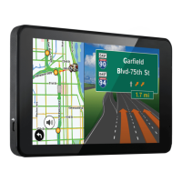
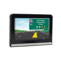
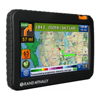
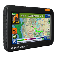
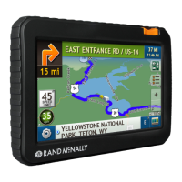
Overview of the main navigation map interface.

Navigation Aids: Exits Quick View

Navigation Guidance: Maneuvers and Speed

Directions Slide-Out List

Viewing detailed maneuver instructions and route options.

Virtual Dashboard: Driving Data Display

Virtual Dashboard Overview

Comprehensive display of driving data, times, and trip progress.

Trip Information Management

Manually Resetting Trip Data

Steps to manually reset trip data like odometers and hours.

Advanced Navigation Views

Junction View

Visual guide for complex intersections and lane guidance.

Turn View

Displays upcoming turns with lane information.

Route Options and Avoidance

Tools & Features: Traffic Information

Traffic Data Usage

Utilizing traffic data for route optimization and alerts.

Tools & Features: Traffic Icons

Tools & Features: Weather Information

Weather Data Access

Accessing and displaying weather forecasts and impacts.

Tools & Features: Fuel Price Information

Tools & Features: Truck-Specific Tools

Truck Tools Overview

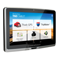
Accessing various truck-specific tools and information.

Timers, Mileage, Trails, and Fuel Records

Viewing driving timers, mileage, trails, and fuel logs.

Tools & Features: Timers and Trip Data

Managing Driving Timers

Recording and managing driving session, duty, and maintenance timers.

Tools & Features: Mileage Logs

Tools & Features: Fuel Log Management

Fuel Log Entry and Viewing

Recording and viewing fuel purchase details and economy.

Tools & Features: Quick Planner

Tools & Features: Road Atlas Information

Dash Cam Functionality

Dash Cam Settings Configuration

Settings for video/GIF quality, audio, and segments.

Related product manuals