3.4
NAVIGATION
WITH
THE
RADAR
3.4.1
Ob11lnln11
Poalllon
fix
The
Model
R20
Radar
is
an
accurate
and
reliable navigational
aid
for
determining
your
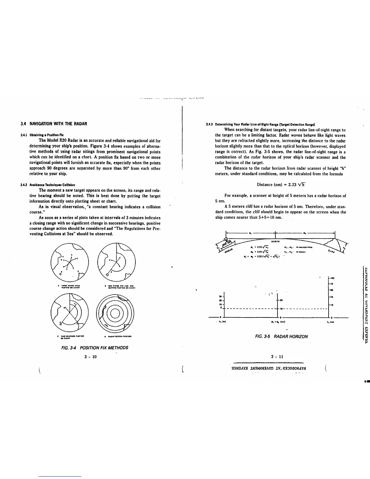
ship's position. Figure
3-4
shows examples
of
alterna-
tive methods
of
using
radar sitings
from
prominent
navigational
points
which
can
be
identified
on
a chart. A position
fix
based
on
two
or
more
navigational
points
will
furnish
an
accurate
fix,
especially
when
the points
approach
90
degrees are separated
by
more
than
90°
from
each other
relative
to
your
ship.
3.4.2
Avold1nce
Ttchnlquea
Colllalon
The
moment
a
new
target appears
on
the screen, its range
and
rela-
tive bearing
should
be
noted. This
is
best
done
by
putting the target
information directly onto plotting sheet or chart.
As
in
visual
observation,.
"a
constant bearing indicates a
collision
course."
As
soon
as
a series
of
plots taken
at
intervals
of
3 minutes indicates
a closing range
with
no
significant change
in
successive bearings, positive
course change
action
should
be
considered
and
"The Regulations
for
Pre-
venting
Collisions
at Sea"
should
be
observed.
(
.
'1\c
A IMlllll llAJtGI AACI
"on10
OH
CMAIH
t
I~
llALlllMI
P\01UD
ON CMAfllf
•
°"'
••frtOI
••c
•'-O
°""
llAlll
..
0
PlOUlO
Ott
CH•••
0 •ADA"
IUllN
'MltlOH
FIG.
3·4
POSITION
FIX
METHODS
3 -
10
-..•
.._,
•
•-
t "
~·
¥•L-I
~
I
'-'''
.._
.....
l
.
l
·3.4.3
Delermlnlna
Your
Rad1r
Llne·of·Slahl
Ranae
(T1r1et
Delectlon
Ranae)
When
searching
for
distant targets, your radar line-of-sight range
to
the target
can
be
a
limiting
factor.
Radar
waves
behave
like
light
waves
but
they are refracted slightly more, increasing the distance
to
the radar
horizon
slightly
more
than
that
to
the optical
horizon
(however,
displayed
range
is
correct).
As
Fig.
3-5
shows, the radar line-of-sight range
is
a
combination
of
the radar
horizon
of
your
ship's radar scanner
and
the
radar
horizon
of
the target.
The distance
to
the radar horizon
from
radar scanner
of
height
"h"
meters, under standard conditions,
may
be
calculated
from
the
formula
Distance
(nm)
=
2.
23
v'h
For example, a scanner at height
of
5 meters
has
a radar
horizon
of
5
nm.
·
A 5 meters
cliff
has
a radar
horizon
of
5
nm.
Therefore, under stan-
dard
conditions, the
cliff
should
begin
to
appear
on
the screen
when
the
ship
comes nearer
than
5+5=
10
nm.
••
EAATH
a,•
UJ~
a,,
a,,
a, •
UJ
,f'h; •1 •
•1
'
a, • a, •
UJ
1"'4 •
y,;;
I
100
II
IO
~t---
------
-
--
-
~
~t--
h
-----
-----
-
~:_
-~.o
IS
•
tr.
1
tml
..........
"1lml
FIG.
3-5
RADAR
HORIZON
3 -
11
3SN3dX3
lN3WNH3AOO
lV,03~000Hd3H
(
f;
"t
~
c
t:
c:
~
>
....;
t
<
!'".
~
~
I"'.
?.
...;
s
Ir.
:>!
v.
rr
.,,.



 To Next Page