Do you have a question about the Renault Carminat TomTom and is the answer not in the manual?
Precautions for safe operation of the navigation system while driving.
Driver vigilance and road condition adherence are paramount.
Guidelines for system maintenance and use of SD cards.
Explanation of the navigation system's components and data sources.
How the GPS receiver uses satellites to determine vehicle position.
Explanation of the various elements displayed on the navigation map screen.
Information about the digital map stored on the SD card.
Details on services like HD Traffic, local search, and weather.
How the system suggests routes using maps, sensors, and traffic info.
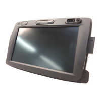
Detailed explanation of the central control unit's buttons and functions.
Explanation of the remote control unit's buttons and functions.
Information on the SD card's content and map update procedures.
Step-by-step guide on how to insert the SD card into the system.
Instructions on how to safely remove the SD card from the system.
How the system automatically turns on with the ignition or via the audio system button.
How the system deactivates automatically or manually.
Procedure to reset system parameters and delete personal data.
Instructions on moving through menus using central or remote controls.
How to confirm selections or return to previous menus.
How soft buttons are used for selection and confirmation.
How to adjust the audio volume during voice instructions.
Explanation of symbols and indicators on the navigation map.
Accessing the menu to select various destination entry methods.
Finding destinations like restaurants, museums, or car parks.
Steps to enter a full address, including country, city, street, and number.
How the system calculates and presents route options after destination entry.
Options to change the planned route, like adding waypoints or avoiding roadblocks.
Calculating a new route from the current location to the destination.
Viewing route details like text, images, demo, summary, or traffic before guidance.
Planning routes to avoid specific road sections or traffic jams.
How to stop and resume navigation guidance.
Changing the route to include a specific intermediate location.
Adding intermediate points (waypoints) to create a multi-stop itinerary.
Planning journeys by selecting start and end points beforehand.
Receiving up-to-date traffic information via TMC or HD Traffic.
Configuring preferences like automatic delay minimization and audible alerts.
Altering the journey based on the latest traffic data.
Overview of traffic incidents affecting the planned route.
Steps to access LIVE Services via the MENU button.
High-quality traffic information service using mobile phone data.
Information on mobile and fixed speed camera alerts.
Selecting locations like Home, Address, or Recent Destination to save as Favorites.
Steps to remove or rename saved Favorite entries.
Accessing phone numbers for emergency services and local facilities.
Navigating to nearby service centres like repair shops or hospitals.
Displaying current location address and GPS coordinates.
Configuring warning times and sounds for speed cameras and alerts.
Manually reporting the location of fixed or mobile speed cameras.
Enabling or disabling speed camera warnings.
Explanation of distance markers (red, yellow, green) for reversing.
Deleting all system information and returning to default settings.
Deleting only personal data like favorites and destinations.
| Voice Guidance | Yes |
|---|---|
| Points of Interest | Yes |
| Display Resolution | 480 x 272 pixels |
| GPS | Yes |
| Speed Camera Alerts | Yes |
| Lane Guidance | Yes |
| SD Card Slot | Yes |
| Compatibility | Renault vehicles |
| Display Type | LCD |
| Screen Size | 5.8 inches |
| Navigation Software | TomTom |
| Traffic Information | RDS-TMS |