Do you have a question about the Renault Media Nav and is the answer not in the manual?
Describes safe operation of controls and volume settings for driver awareness.
Advises driver vigilance and awareness of road signs, as maps may not be current.
Warns against dismantling, modification, or inserting foreign bodies into the system.
Highlights distraction and legal aspects of phone use while driving.
Explains FM/AM listening and RDS features like traffic bulletins.
Describes connecting personal stereos via Jack, USB, or Bluetooth.
Details call management, contact transfer, and dialing emergency numbers.
Explains how the system calculates position and suggests routes using GPS.
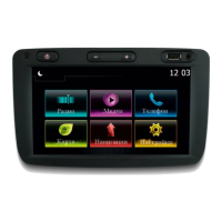
Describes different screen areas and their functions.
Details elements of the navigation display like map mode and street names.
Explains automatic and manual system activation, including temporary use.
Describes automatic system shutdown with vehicle ignition.
Explains controls for radio station search and source selection.
Describes tap and long press interactions on the touchscreen for selection and scrolling.
Explains how to mute and unmute audio playback.
Describes automatic volume adjustment based on vehicle speed.
Explains how to configure RDS, TA, Region, AM, and update list.
How to choose between USB, iPod, Bluetooth, and AUX sources.
Details USB and Bluetooth connection for audio devices.
Access to sound settings menu.
Overview of how the navigation system works using GPS and digital maps.
How to show the map and navigate it using touch controls.
How to check current position and search for nearby POIs.
Displays country-specific driving info: speed limits, restrictions, etc.
How to search for nearby services like repair, medical, police, or gas stations.
Lists various methods for entering a destination.
Step-by-step guide to entering address details like country, town, street.
Options before confirming a destination: OK, Add to favorites, Info, Return.
How guidance starts automatically after entering a destination.
How to view destination, time, and distance details of the route.
How to modify the route by adding/removing waypoints and reordering stages.
How to set up various navigation warnings.
How to enable speed limit warnings (audio and visual).
How to configure route calculation parameters.
Explains route priorities: Fast, Short, and Eco.
How to check GPS satellite status and information.
| Navigation | Yes |
|---|---|
| Voice Control | Yes |
| Touchscreen | Yes |
| SD Card | Yes |
| Apple CarPlay | No |
| Android Auto | No |
| Resolution | 800 x 480 pixels |
| Auxiliary Input | Yes |
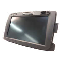
| Screen Size | 7 inches |
| Connectivity | Bluetooth |
| Audio | Radio |
| Maps | Pre-installed maps |
| Compatibility | Renault vehicles |