Do you have a question about the Samyung ENC N500 and is the answer not in the manual?
Owner's responsibility for safe operation and installation.
Procedure for cleaning the chart plotter screen.
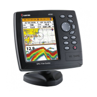
Technical specifications for N500 and N560 models.
List of items included in the product package.
Instructions for bracket and flush mounting the unit.
Explanation of the function of each button on the unit.
One-touch method for storing a MOB location.
Procedures for powering the unit on and off manually or automatically.
Settings for display brightness, night mode, and background color.
Overview of the chart window and its displayed navigation data.
Using the chart for planning courses and navigation.
Navigating to a specific waypoint or chart point.
Navigating along a predefined route of waypoints.
Understanding the elements and symbols of the sonar display.
Using dual frequencies for improved fish detection and bottom analysis.
Adjusting signal strength and threshold for optimal sonar performance.
3D view of vessel navigation to a destination point.
Selecting different layouts and customizing individual gauges.
Methods for creating waypoints from the chart or waypoint list.
How to reposition waypoints on the chart or within the waypoint list.
Removing waypoints from the chart or the waypoint list.
Creating and editing routes directly on the chart window.
Creating and managing routes within the dedicated route window.
Displaying GPS satellite acquisition and position data.
Accessing and viewing tide height and phase data.
Displaying information about nearby AIS-equipped vessels on the chart.
Handling distress calls and polling vessel positions via DSC.
Loading and deleting NAVTEX navigational and safety messages.
Displaying real-time engine errors and malfunctions.
General settings for the unit's basic operation and features.
Restoring all unit settings to their default factory values.
Filtering and configuring display options for AIS vessel data.
Configuring various audible alarms for navigation and system events.
Customizing chart display options like rotation, palette, and data.
Selecting the appropriate map datum for chart accuracy.
Correcting position discrepancies between chart and actual location.
Configuring sonar frequency, palette, and advanced options.
Advanced sonar options including interference and noise filters.
Configuring GPS source, DGPS, and navigation data settings.
Setting the DGPS source for enhanced positional accuracy.
Settings for recording, displaying, and coloring boat tracks.
Saving, loading, deleting, and formatting data on the user card.
Saving waypoints, routes, and tracks to a user card.
Filtering AIS vessels by type, distance, or speed for clarity.
Configuring AIS alarms for proximity, dangerous vessels, and TCPA/CPA.
Alarms for arrival radius, anchor, XTE, and proximity to dangerous points.
Configuring NMEA communication settings for external devices.
Calibrating boat speed and water temperature readings.
Lists optional sensors and instruments compatible with the unit.
Details on connecting various external devices and antennas to the unit.
Wiring instructions for the main power and data cable.
Setup and connection for optional DSC VHF radio units.
Connecting to an NMEA 2000 network for marine electronics.
Instructions for fitting and connecting the sonar transducer.
Blanking unused connectors, adjusting display, and inserting chart card.
Checking the unit's ability to acquire GPS satellites.
Details on warranty coverage, exclusions, and limitations of liability.
| GPS | Yes |
|---|---|
| Power Consumption | 5W |
| Display Size | 5 inches |
| Display Type | TFT LCD |
| Update Rate | 1 Hz |
| Acquisition Time (Warm Start) | 38 seconds |
| Chart Format | S-57 |
| Storage Temperature | -20℃ |
| Humidity | 95% |
| Interface | NMEA 0183 |
| Antenna | External |