Do you have a question about the Xinuo Wal-way iChart and is the answer not in the manual?
Details copyright, reproduction, and usage permissions for the manual.
Highlights critical safety warnings and explains the notation system used in the manual.
Lists 11 essential safety precautions to prevent equipment failure and ensure safe operation.
Details the physical appearance of the HM-5817 unit and lists its included accessories.
Provides guidance on installing and connecting the HM-5817 unit and its components.
Explains how to power on the system and introduces the front panel keyboard functions.
Covers GPS system principles, satellites, and structure.
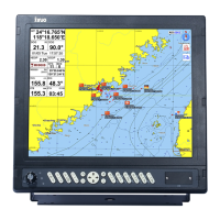
Introduces the system and explains the data displayed on the main navigation screen.
Details chart viewing, zooming, brightness adjustment, display modes, and rotation.
Explains how to navigate menus and configure system parameters.
Covers managing tracks: switching, coloring, recording, and deleting.
Guides on adding, modifying, deleting, and invoking waypoints.
Details adding, modifying, and deleting markers.
Covers adding, setting, deleting, and moving beacons.
Explains adding, modifying, deleting, invoking, and selecting waypoints in routes.
Covers viewing other vessels, AIS information, hardware connection, and display settings.
Procedure for cancelling the current navigation session.
Includes tide, chart, calendar inquiries, distance measurement, and port info.
Features for saving and managing the ship's current position (Man Over Board).
Describes alarm functions for waypoints and planned routes.
Details Chinese and English input methods for system interaction.
Covers system, alarm, chart color, display, sound, signal, hardware, GPS, and version settings.
Provides detailed physical dimensions and mounting specifications for the HM-5817 unit.
Illustrates the connections and layout for installing the HM-5817 system and its peripherals.
Guides on the step-by-step process for embedding the HM-5817 unit into a panel.
Details the procedure for upgrading the HM-5817 system software using a USB drive.
Shows how to fix the installation and adjust the unit's viewing perspective.
| Brand | Xinuo |
|---|---|
| Model | Wal-way iChart |
| Category | Marine GPS System |
| Language | English |