Do you have a question about the Alpine NVD-W912 and is the answer not in the manual?
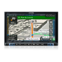
Accessing audio screen and navigation guide view within the audio screen.
Returning to map view and utilizing voice prompts during guidance.
Visual cues indicating the correct lanes to take during navigation.
Differentiated lane signs for clarity at junctions, with others dimmed.
Accessing the address input screen via the Navi Menu.
Choosing the destination city, with default options or manual entry.
Navigating to the intersection input screen.
Entering city and street names for intersection destination.
Accessing the quick search function via the Navi Menu.
Typing the name of the desired place into the search field.
Navigating to the route editing functions from the Route menu.
Options for adding, deleting, or reordering destinations in a route.
Accessing the prompt to cancel the currently active route.
Finalizing the cancellation of the active route and its waypoints.
Selecting a location and initiating the save process to the address book.
Assigning a name to the location and saving it as a new entry.
How the system warns users about exceeding speed limits on road segments.
Details on audio and visual warnings for speed limit violations.
Accessing the speed warning configuration menu through system settings.
Using a slider to set the threshold for triggering speed warnings.
How historical and real-time data aids in route planning.
TMC reception and route recalculation based on current traffic conditions.
Displaying traffic event categories like accidents and congestion on the map.
Tapping events to see details and affected road segments.
Navigating to the traffic feature configuration menu via system settings.
Enabling smart routes or disabling the traffic receiver feature.
How to access the quick menu from any screen.
POI search and route deletion capabilities available.
Navigating to route settings through the system menus.
Choosing preferences like highways, tolls, and unpaved roads for routing.
Using the cursor as a destination or alert point on the map.
Interacting with POIs or alert points on the map for route planning.
Using touch gestures to pan and zoom the map.
Modifying vertical view angle and map scaling in 3D mode.
Navigating to the menu language selection screen.
Choosing a language and restarting the system to apply changes.
Changes to the North Up/Heading Up function and compass icon.
Changes regarding address book editing and history access.
New routing methods and adjustments to curve warning distance.
Explains satellite search display and automatic zoom functionality.
Information on quick menu disappearance and address book editing limitations.
Guidance on stopping verbal traffic and speed warnings.
| Display Size | 7 inches |
|---|---|
| Resolution | 800 x 480 pixels |
| GPS Navigation | Yes |
| Bluetooth | Yes |
| USB Port | Yes |
| SD Card Slot | Yes |
| Touchscreen | Yes |
| DVD Playback | Yes |
| CD Playback | Yes |
| AM/FM Tuner | Yes |
| iPod Compatibility | Yes |
| iPhone Compatibility | Yes |
| Backup Camera Input | Yes |
| Steering Wheel Control | Yes |
| Power Output | 50W x 4 |
| Audio Formats Supported | MP3, WMA, AAC |
| Satellite Radio | SiriusXM Ready |
