Do you have a question about the Becker active.6 CE LMU BE B30 and is the answer not in the manual?
Details the terms and conditions of the 24-month warranty for Becker units.
Outlines essential safety precautions for using the navigation device and its components.
Describes the structure and content of the operating manual.
Explains the intended use of the navigation device in vehicles.
Introduces the navigation functionality using GPS.
Describes Bluetooth connectivity for hands-free phone functions.
Instructions for unpacking the device.
Guide to verify all items are present after unpacking.
Compares features across different navigation system models.
Lists and illustrates all items included in the product package.
Details the basic unit and included accessories.
Describes the core electronic components of the navigation device.
Explains how to connect the device via the car's cigarette lighter.
Details the use of the USB cable for PC connection.
Explains how the unit bracket is used for mounting.
Refers to Quick Start Guide and Operating Instructions.
Advises contacting the dealer for repairs.
Illustrates and lists the basic device, USB cable, unit holder, and power supply.
Identifies buttons and displays on the front of the device.
Details the ON/OFF switch and standby switch.
Shows slots for SD card, USB, and camera connections.
Provides guidelines for cleaning and maintaining the device.
Outlines the steps to start the device after unpacking.
Instructions for connecting the power supply via the car's cigarette lighter.
Explains connecting to power via the mains adapter.
Describes connecting the device to vehicle audio systems.
Instructions for connecting a rear view camera.
Advice on positioning the unit holder for visibility and safety.
Detailed steps for attaching the unit holder to the windscreen.
How to turn the device on, off, or put it into sleep mode.
Detailed steps for powering on the device and initial setup.
Procedures for switching the device off or to sleep mode.
Explains when and how to calibrate the touch screen.
Describes the main menu as the starting point for applications.
How to input characters using the on-screen keypad.
Introduction to the PC application for managing device content.
Step-by-step guide for installing the Content Manager software.
Troubleshooting common malfunctions and restart procedures.
Explains the basic principles of navigation and GPS technology.
Crucial safety guidelines for using navigation mode.
How to access and start navigation functions from the main menu.
Setting and modifying the home address for navigation.
Accessing and selecting previously visited destinations.
Viewing and modifying stored destination details.
Managing user-defined points of interest.
Importing and using Outlook contacts for navigation.
Introduction to the menu for entering new destinations.
Steps to enter a destination address.
How to select points of interest like restaurants or hotels.
Planning routes with multiple waypoints.
Specific steps for entering an address.
Entering full address details and starting navigation.
Entering a town name or ZIP code to find a destination.
Entering street names and house numbers.
Entering a house number to specify the destination.
Showing the calculated route on the map before starting guidance.
Saving a destination for quick access.
Initiating the route guidance process.
Using voice commands to enter addresses.
Advanced voice control for device functions.
Defines and lists types of points of interest.
Searching for points of interest online.
Finding points of interest near the current location.
Finding points of interest near a specified address.
Finding points of interest close to the destination.
Finding points of interest along the planned route.
Searching for points of interest by name.
Choosing a destination by tapping on the map.
Entering destinations using geographic coordinates.
Planning routes with multiple waypoints.
Modifying saved routes (adding stages, renaming, deleting).
Choosing a stored route and beginning guidance.
Rearranging destinations to find the most efficient route.
Accessing the menu for navigation function settings.
Selecting map display modes (2D, 3D, split-screen).
Choosing which points of interest to display on the map.
Displaying POIs and TMC reports on the route overview.
Selecting additional information displayed during route guidance.
Editing driving profiles and route selection settings.
Choosing vehicle profiles (car, truck, bicycle) affecting route calculation.
Setting truck/mobile home profiles with dimensions and weight.
Choosing between fast, economical, short, or easy routes.
Excluding roads like motorways, ferries, or toll roads from calculation.
Configuring settings for traffic announcement reception.
Accessing traffic information via server connection.
Adjusting voice guidance settings like voice, volume, and noise level.
Selecting types of warnings and warning sounds.
Enabling/disabling driver alerts and setting warning sounds.
Selecting speed limit display and audible warnings for exceeding them.
Managing blocked roads, setting times, and days.
Calculating economical routes using fuel consumption data.
Selecting the correct time zone for accurate arrival times.
Resetting navigation settings to factory defaults.
Receiving traffic announcements via radio stations.
Receiving traffic updates via a data connection.
Graphical display of TMC messages and traffic problems on the map.
Receiving traffic announcements and calculating dynamic routes.
Configuring how traffic announcements affect route calculation.
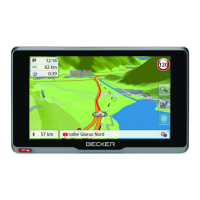
Using the map display for route guidance or current position.
Map display when route guidance is active.
Information displayed in the info box during route guidance.
Navigational instructions using arrows and distance.
Animated lane guidance for complex junctions.
Detailed lane situation views at motorway junctions.
Adjusting the volume of navigation announcements.
Adjusting the map scale using zoom buttons.
Displaying POIs and TMC events on the selected route.
Three assistants providing information for traffic situations.
Suggesting detours to avoid traffic jams.
Assistance in finding parking near the destination.
Changing settings for route guidance and map display.
Showing the complete route and description.
Viewing the route section by section.
Blocking specific road sections temporarily or permanently.
Displaying and selecting alternative routes.
Terminating active route guidance.
Adding or removing intermediate destinations.
Temporarily blocking a road ahead to force a detour.
Switching the display mode between day and night.
Showing current location, address, and GPS reception.
Making emergency calls via the navigation system.
Entering a destination when route guidance is not active.
Moving to the next destination in a multi-stop route.
Displaying route calculation results considering vehicle specifications.
Warnings about road restrictions on the planned route.
Displaying the route and highlighting avoided sections due to vehicle settings.
Showing elevation changes along the route.
Accessing the phone functions from the main menu.
Overview of options in the telephone menu.
Entering a number or selecting from the phonebook to make a call.
Accessing and displaying phonebook entries from SIM or phone memory.
Displaying dialled, answered, or missed calls chronologically.
Initiating a call directly from the call list.
Viewing and modifying call list entries.
Connecting a Bluetooth phone to the navigation device.
Displaying and managing connected Bluetooth devices.
Automatically connecting to the last used cell phone.
Finding and connecting to Bluetooth phones.
Ending the Bluetooth connection to a cell phone.
Overview of options for making, accepting, and ending calls.
Steps to initiate a phone call.
Handling incoming calls and available options.
Procedures for terminating an active call.
Control options available while on a call.
Accessing settings for the telephone mode.
Switching the Bluetooth function on or off.
Setting automatic acceptance of incoming calls.
Adjusting ringtone and call volume.
Updating or retransferring phonebook entries.
Viewing images saved on the device or memory card.
Displaying country-specific information like speed limits.
Blocking road sections for route calculation.
Displaying journey data like speed and distance.
Navigating the image viewer interface.
Choosing and viewing images from folders.
Zooming in on images for detailed viewing.
Changing the orientation of displayed images.
Automatically displaying pictures sequentially.
Observing expected traffic flow based on historical data.
Permanently blocking road sections to avoid them.
Changing basic settings for all device applications.
Information on device power sources and status display.
Device automatically switching to sleep mode.
Setting the display mode to automatic, day, or night.
Adjusting display brightness for day and night.
Displaying interface texts in various languages.
Choosing and confirming the desired language.
Switching navigation device signal tones and button clicks on/off.
Displaying the image from a connected rear view camera.
Selecting and saving different driver profiles.
Using a phone as a trigger to automatically change driver profiles.
Resetting the device to its original factory settings.
Calibrating the touch screen for accurate response.
Establishing a data connection via a WiFi network.
Definition of Global Positioning System.
Definition of Traffic Message Channel.
Table comparing models and their technical features.
Declaration of device compliance with EC directives.
Information on proper disposal of electrical and electronic devices.
Information on returning and disposing of used batteries.
Step-by-step instructions for battery removal.
| Brand | Becker |
|---|---|
| Model | active.6 CE LMU BE B30 |
| Category | Car Navigation system |
| Language | English |