Do you have a question about the Becker professional.6 LMU BE B50 and is the answer not in the manual?
Provides warranty details for BECKER units, including duration and conditions for claims.
Provides essential safety guidelines for using the device, handling, and potential hazards like electrocution.
Warns about the danger of electrocution and the need to switch off power before cleaning.
Explains the product's use, navigation capabilities, and telephone connectivity via Bluetooth.
Lists all items included in the package and describes the basic unit and accessories.
Provides guidelines for cleaning and maintaining the navigation device and its accessories.
Covers initial start-up, powering, and connecting to power sources.
Information about the touch screen interface, operation, and calibration.
How to select destinations via home address, last destinations, contacts, and points of interest.
Creating routes, simulating routes, optimizing, and starting navigation.
Selecting map view modes (2D/3D, split screen, arrow mode) and customizing display.
Selecting guidance info, detour assistant, and parking assistant for enhanced navigation.
Influences route calculation and arrival times based on vehicle type.
Configuring TMC settings and using Live Traffic via data connection.
Making settings for voice announcements, including voice selection, volume, and noise level.
Selecting warnings for speed limits, cameras, environmental zones, and truck restrictions.
Unblocking or modifying permanently blocked roads, setting block times.
Receiving traffic announcements via radio stations and how they are processed.
Receiving up-to-date traffic announcements via a data connection.
Using the map display for route guidance or to show current position and warnings.
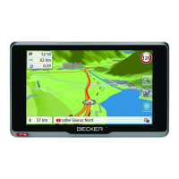
Details the elements shown on the map display when route guidance is active.
Detailed view of lane situations at motorway junctions and tunnel views.
Adjusting the volume of navigation announcements, including mute function.
SituationScan, detour assistant, and park assistant for managing traffic situations.
Changing settings for route guidance, map display, and route preferences.
Viewing the entire route, route description, and managing stopovers.
Blocking specific road sections temporarily or permanently to avoid them.
Displaying alternative routes and canceling route guidance.
Adding or removing intermediate destinations (stopovers) during route guidance.
Showing current location, address, GPS reception, and country information.
How to make an emergency call using the device if a mobile phone is connected.
How to enter a destination when route guidance is not active.
Displaying and selecting various calculated routes.
Displays information about restrictions and warnings for trucks on planned routes.
Showing the elevation profile of a route or alternative routes.
Connecting to cell phones via Bluetooth, managing devices, and automatic connection settings.
Overview of options in the telephone menu: dial, phonebook, call list, search, disconnect.
Displays phonebook entries from SIM card and phone memory, allows calling numbers.
Displays dialled, answered, or missed calls chronologically.
Requirements and options for establishing a Bluetooth connection to a cell phone and managing devices.
How to search for and connect to Bluetooth-enabled cell phones.
Making, accepting, ending calls, and using in-call control options like volume and microphone.
Accessing all settings relevant to the telephone mode.
Switching Bluetooth on/off and setting automatic call acceptance.
Adjusting ringtone and call volume, including mute function.
Updating or retransferring stored phonebook entries to the navigation device.
Displaying images, country information, and rear view camera feed.
Navigating the image viewer menu to select images, start slide shows, and access settings.
Observing expected traffic flow and receiving warnings about road restrictions.
Permanently blocking road sections to avoid them.
Provides data display with speeds, distances, and a stopwatch with lap recording.
Changing basic system settings like language, display, and keyboard layout.
Information on operating the device with battery or external power and automatic on/off settings.
Adjusting day/night display modes and screen brightness.
Selecting display language and changing color schemes for icons and design elements.
Displaying the image from a connected rear view camera.
Selecting, renaming, and deleting driver profiles for personalized settings and destinations.
Resetting the device to factory settings and calibrating the touch screen.
Establishing a data connection to a WiFi network using a mobile hotspot.
Definitions of terms like GPS, Bluetooth, TMC, SD card, and JPEG.
Table comparing features and technical specifications across different navigation system models.
Declares compliance with EC directives and R&TTE regulations.
Information on proper disposal of electrical/electronic products and batteries.
Instructions on how to remove the battery before unit disposal.
| Brand | Becker |
|---|---|
| Model | professional.6 LMU BE B50 |
| Category | Car Navigation system |
| Language | English |