EasyManuals Logo

dji AVATA 2 User Manual

dji AVATA 2
101 pages
To Next Page IconTo Next Page
To Previous Page IconTo Previous Page
Page #26 background imageLoading...
Page #26 background image
DJI Avata 2 User Manual
26
  
©
2024 DJI All Rights Reserved.
Flight Safety
After completing pre-flight preparations, it is recommended to train your flying skills and
practice ying safely. Pick a suitable area to y in according to the following ight requirements
and restrictions. Strictly abide by local laws and regulations when flying. Read the Safety
Guidelines before ight to ensure safe use of the product.
Flight Restrictions
GEO (Geospatial Environment Online) System
The DJI Geospatial Environment Online (GEO) System is a global information system that
provides real-time information on flight safety and restriction updates and prevents UAVs
from flying in restricted airspace. Under exceptional circumstances, restricted areas can
be unlocked to allow flights in. Prior to that, the user must submit an unlocking request
based on the current restriction level in the intended flight area. The GEO system may
not fully comply with local laws and regulations. Users shall be responsible for their
own flight safety and must consult with the local authorities on the relevant legal and
regulatory requirements before requesting to unlock a flight in a restricted area. For more
information about the GEO system, visit https://fly-safe.dji.com.
Flight Limits
For safety reasons, ight limits are enabled by default to help users operate this aircraft safely.
Users can set ight limits on height and distance. Altitude limits, distance limits, and GEO zones
function concurrently to manage flight safety when GNSS is available. Only altitude can be
limited when GNSS is unavailable.
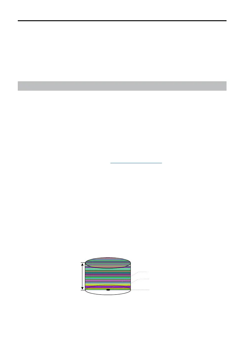
Flight Altitude and Distance Limits
Max altitude restricts the ight altitude of the aircraft, while max distance restricts the ight
radius around the Home Point. These limits can be set using the goggles for improved ight
safety.
Max Distance
Home Point
Height of aircraft when taking off
The Last updated Home Point
Max Altitude

Other manuals for dji AVATA 2

Questions and Answers:

Question and Answer IconNeed help?

Do you have a question about the dji AVATA 2 and is the answer not in the manual?

dji AVATA 2 Specifications

General IconGeneral
TypeQuadcopter
Product colorBlack
Construction typeReady-to-fly (RTF)
Suitable for outdoor useYes
Maximum speed27 m/s
Wi-Fi standards802.11a, 802.11g, Wi-Fi 4 (802.11n), Wi-Fi 5 (802.11ac)
Number of rotors4 rotors
Bluetooth version5.0
Maximum flight time23 min
Maximum flight altitude5000 m
Maximum weight capacity- kg
Maximum wind resistance10.7 m/s
Horizontal hover accuracy0.3 m
Maximum operating distance13000 m
Megapixel12 MP
Video color modesD-Log, Normal
Video resolutions1440 x 1080, 1920 x 1080, 2688 x 1512, 2688 x 2016, 3840 x 2160 pixels
Maximum frame rate60 fps
Optical sensor size1/1.3 \
Camera shutter speedVideo: 1/8000-1/30, Photo: 1/8000-1/50 s
Mechanical tilt range-95 - 90 °
Normal focusing range0.6 - ∞ m
Supported file systemsexFAT
Angular vibration range-0.01 - 0.01 °
Image formats supportedJPEG
Maximum aperture number2.8
Video formats supportedH.264, H.265, MP4
Maximum image resolution4000 x 3000 pixels
Maximum video resolution3840 x 2880 pixels
Field of view (FOV) angle155 °
Bitrate at maximum video resolution130 Mbit/s
Built-in processor-
Internal memory46 GB
Operating frequency2400 - 2483.5 MHz
Battery voltage14.76 V
Battery capacity2150 mAh
Antennas quantity4
Operating temperature (T-T)-10 - 40 °C
Equivalent Isotropically Radiated Power (EIRP)10 dBmW
Package typeBox
Cables includedUSB Type-C
Weight and Dimensions IconWeight and Dimensions
Depth212 mm
Width185 mm
Height64 mm
Weight377 g

Related product manuals