DJI Avata 2 User Manual
©
2024 DJI All Rights Reserved.
27
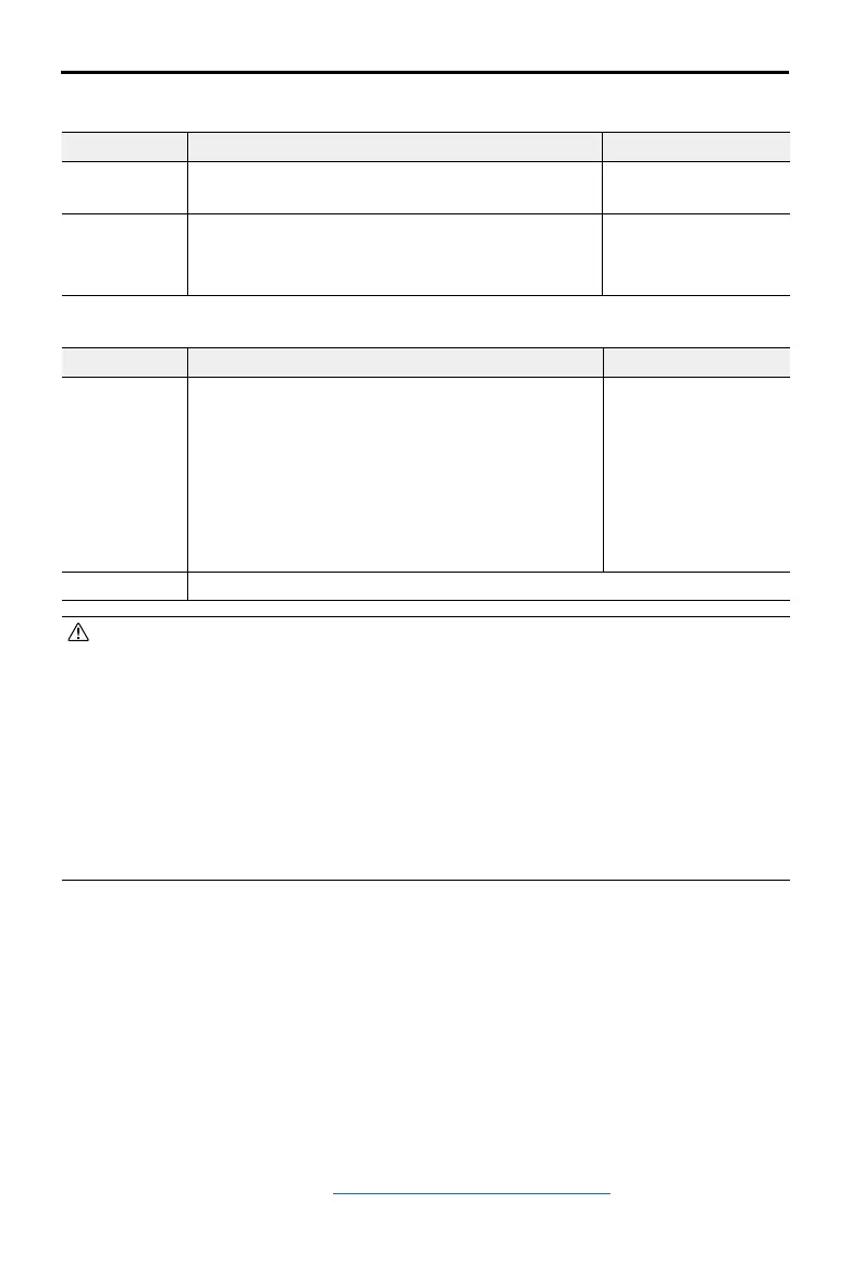
Strong GNSS Signal
Flight Restrictions Prompt in Goggles
Max Altitude Flight altitude must be below the preset height.
Max ight altitude
reached.
Max Distance
The straight-line distance from the aircraft to the
Home Point cannot exceed the max ight distance
set in the goggles.
Max ight distance
reached.
Weak GNSS Signal
Flight Restrictions Prompt in Goggles
Max Altitude
• Altitude is restricted to 50 m from the takeo point
if lighting is sucient.
• Altitude is restricted to 3 m above the ground if
lighting is not sufficient and the infrared sensing
system is operating.
• The altitude is restricted to 50 m from the takeo
point if lighting is not sufficient and the infrared
sensing system is not operating.
Ma x f l ight a l t itud e
reached.
Max Distance No limits
• Each time the aircraft is powered on, the altitude limit of 3 m or 50 m will be automatically
removed as long as the GNSS signal ever becomes strong (GNSS signal display white
or yellow) once, and the limit will not take eect even if the GNSS signal becomes weak
afterwards.
• If the aircraft ies out of the set ight range due to inertia, users can still control the aircraft
but cannot y it any further. If the aircraft ies above the altitude limit, it will descend below
the altitude limit at 5 m/s. If the aircraft ies into an Altitude Zone, landing will be triggered
after a 100-second countdown.
• For safety reasons, DO NOT fly the aircraft close to airports, highways, railway stations,
railway lines, city centers, or other sensitive areas. Only y the aircraft within a visual line of
sight.
GEO Zones
The DJI GEO system designates safe ight locations, provides risk levels and safety notices for
individual flights and offers information on restricted airspace. All restricted flight areas are
referred to as GEO Zones, which are further divided into Restricted Zones, Authorization Zones,
Warning Zones, Enhanced Warning Zones, and Altitude Zones. Users can view such information
in real-time in DJI Fly. GEO Zones are specic ight areas, including but not limited to airports,
large event venues, locations where public emergencies have occurred (such as forest res),
nuclear power plants, prisons, government properties, and military facilities. By default, the
GEO system limits takeos and ights in zones that may cause safety or security concerns. A
GEO Zone map that contains comprehensive information on GEO Zones around the globe is
available on the ocial DJI website: https://y-safe.dji.com/nfz/nfz-query.
 Loading...