Do you have a question about the Flytec 6015 and is the answer not in the manual?
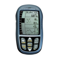
Detailed description of the physical components and their locations on the Flytec 6015 GPS instrument.
Instructions on how to power the instrument on and off, including safety prompts and automatic shutdown features.
Explanation of the function of each key on the instrument's keypad, including short and long press actions.
Principles and tips for intuitive and efficient operation of the instrument during flight.
Overview of the display screen layout, data fields, and how to navigate different graphics and data pages.
Guide on accessing and navigating the instrument's setting menus for configuration and adjustments.
Explains the three altimeter displays (ALT1, ALT2, ALT3) and QNH pressure measurement.
Covers analogue and digital variometer displays, acoustics, and various setting options for climb and sink tones.
Details on speed measurement using a wind vane sensor, stall alarm, and GPS speed display.
Information on how the instrument handles time, date, and flight duration recording.
Explanation of the temperature sensor's role in compensation and display contrast control.
Guidance on understanding GPS signal strength, satellite reception, and factors affecting accuracy.
How the GPS compass and track display work, including orientation and movement dependency.
Managing waypoints, entering coordinates, and their storage capacity on the instrument.
Creating, editing, and flying routes, including competition route features and start procedures.
Techniques and data for optimizing flight performance, including ground speed, wind, and glide ratio.
How flights are automatically saved, the data recorded, and how to perform flight analysis.
Methods for transferring flight data, waypoints, and routes between the instrument and a PC via USB.
How to check the current battery charge level displayed on the instrument.
Instructions and recommendations for safely replacing the instrument's batteries.
Detailed explanation of how barometric altimeters work and factors affecting altitude readings.
Information on GPS reception quality and altitude accuracy, critical for reliable navigation.
Explains the importance of flight memory, IGC files, and digital signatures for flight evidence.
Precautions and procedures to follow if the instrument is exposed to water or moisture.