Do you have a question about the Flytec 6030 and is the answer not in the manual?
Instructions on how to power the instrument on and off.
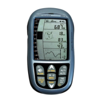
Explanation of the instrument's primary display layout and data fields.
Detailed description of the functions of the instrument's buttons and keys.
Explains the context-dependent operations of the F1 and F2 function keys.
Guide on how to input text using the device's keypad.
How to configure measurement units for display.
Description of the live map view for navigation and flight tracking.
Details on battery types, charging procedures, and status indicators.
Information on customizing the data fields shown on the display.
Guide to accessing and navigating the instrument's main configuration settings.
Explanation of the vertical speed indicator and its features.
Details on the various altimeters and air pressure readings.
Procedure for manually setting the primary altimeter reading.
Covers instrument functions related to air speed measurement.
Explains how indicated and true airspeed are measured and displayed.
How to set up an alarm for low airspeed to prevent stalls.
Displays the aircraft's speed relative to the ground via GPS.
How to display wind direction and speed information.
Function to compensate variometer readings for airspeed changes.
Guidance on selecting optimal speeds for flight efficiency.
Identifies the speed for maximum glide distance.
A visual aid for optimizing speed based on thermal strength.
Information on entering glider polar data for accurate performance calculations.
Configuration of audible alerts and tones for various flight functions.
Information about the device's internal temperature sensor.
Details on how the instrument manages time and date settings.
Automatic recording and display of flight duration.
Various distance calculations for navigation.
Displays the horizontal distance to a selected waypoint.
Shows distance to the last detected thermal lift.
Displays the distance remaining to the designated goal.
Shows distance to the nearest controlled airspace.
Displays the distance from the current position to the takeoff point.
Distance to competition cylinders for start, turnpoints, and goals.
Displays the calculated glide ratio through air or over ground.
Shows altitude relative to glide paths for waypoints and goals.
How to check the GPS signal strength and reception quality.
Using the GPS compass for directional guidance and tracking.
Description of the live map view for flight tracking.
Using instrument features to help relocate thermal lift.
Managing stored locations and their associated navigational data.
Shows the current GPS position in the information field.
Procedure for saving the current location as a new waypoint.
Guide to editing and managing waypoints using the keypad.
How to select and navigate to a specific waypoint.
Understanding key navigational data like track and cross-track error.
Detailed steps for navigating to a specific waypoint.
How to adjust flight path for optimal navigation in crosswinds.
Calculating and using wind component for navigation accuracy.
Creating and managing sequences of waypoints for navigation.
Visual aid for planning the next turn in a route.
Procedure for creating and modifying flight routes.
Setting up and flying competition-specific routes and tasks.
Steps for configuring a competition task with waypoints and cylinders.
Utilizing optimized routes for improved efficiency in competition.
Managing competition start procedures, timing, and types.
Details on starting a competition task by exiting a cylinder.
Details on starting a competition task by entering a cylinder.
Guidance on calculating and executing the final glide to the goal.
Determining optimal altitude for final glide from thermal climb.
Strategies for executing the glide phase to reach the goal.
Instructions for recording and storing flight data in IGC format.
How to view recorded flights on the instrument's map display.
Using recorded flights for scoring, online contests, and record verification.
Setting up warnings and displaying information for restricted airspace.
How to view specific details about airspaces.
Managing which airspaces are active for alerts and warnings.
Loading and managing airspace files stored on an SD card.
Selecting and loading airspace files from an SD card.
Steps to convert and load airspace files using a utility.
Manually inputting or editing airspace data via the keypad.
Transferring recorded flight data from the instrument to a PC.
Configuring device settings using PC software.
Exchanging waypoint and route data between PC and instrument.
Transferring airspace files to the instrument via FlyChart.
Guide to creating airspace files for the instrument using FlyChart.
Procedure for updating the instrument's firmware.
Activating additional features with release codes.
Analyzing raw flight data from IGC files using external software.
Accessing and managing recorded flight data.
Viewing, editing, and managing stored waypoints.
Managing stored flight routes.
Managing restricted airspace data.
Customizing various operational preferences and parameters.
Procedures for resetting and reinitializing the instrument.
Steps to take and consequences of water damage to the device.
Information regarding the product's warranty coverage and exclusions.
Information about the stall alarm function and its settings.
Explanation of the netto variometer and its use.
Clarification of the difference between true and indicated airspeed.
Understanding glider polar curves and best glide speed.
Explanation of McCready theory for optimizing flight speed.
Examples illustrating competition start procedures.
| Resolution | 320 x 240 pixels |
|---|---|
| GPS | Yes |
| Vario | Yes |
| Altimeter | Yes |
| Update Rate | Up to 4 Hz |
| Connectivity | USB |
| Operating Temperature | -10°C to +50°C |
| Display | LCD |
| Battery | Rechargeable Li-ion |