Do you have a question about the Garmin foretrex 301 and is the answer not in the manual?
Explains how buttons and symbols are used in the manual.
Instructions for registering the product online for better support.
Provides contact information for product support in the USA and Europe.
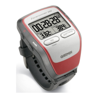
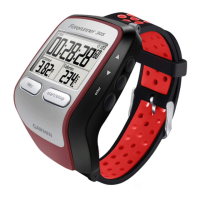
Compares features available on the Foretrex 301 and 401 models.
Directs users to the Garmin website for a list of available accessories.
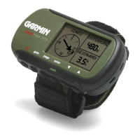
Identifies key components like GPS antenna, buttons, and ports.
Details the primary functions of the device's main buttons.
Explains how to use the up/down buttons for menu scrolling and map zooming.
Provides step-by-step instructions for inserting batteries into the device.
Instructions on how to power on the Foretrex device.
Explains the process of acquiring GPS signals for location tracking.
Describes how to use and adjust the device's backlight.
Introduces the five main pages: Map, Compass, Elevation, Trip Computer, and Main Menu.
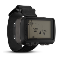
Describes the map page display and its features.
Describes the compass page display and its function.
Describes the elevation page, noting its availability on the 401 model.
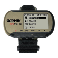
Describes the main menu screen and its navigation.
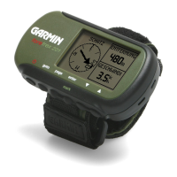
Describes the trip computer page and the data it displays.
Steps to orient the map display with north at the top.
Instructions for deleting recorded track logs from the device.
Guide on how to measure the distance between two points on the map.
Details how the compass page guides navigation and uses GPS for direction.
Provides steps to calibrate the electronic compass for accuracy.
Explains the elevation page and how to calibrate the barometric altimeter.
Describes the trip computer's display of speed, odometer, and other statistics.
Access to create/list waypoints, manage tracks, create/list routes, and customize settings.
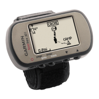
Explains how to record, store, and navigate to waypoints.
Details how to edit a waypoint's name, symbol, elevation, and coordinates.
Steps for selecting a new symbol and editing the name of a waypoint.
Steps for entering waypoint elevation and editing location coordinates.
Steps for removing a waypoint from the device.
Steps to access and view the hunting and fishing information.
Steps to access and view the sun and moon data.
Instructions on saving recorded tracks for later use or navigation.
Instructions for clearing the currently active track log.
Steps to follow a previously saved track.
Steps to create a new route by selecting waypoints.
Instructions on how to follow a created route.
Describes options available in the map menu, such as pan, clear track log, and measure distance.
Settings for map preferences like orientation and visibility of tracks/waypoints.
Details options in the compass menu, including calibration.
Options for the elevation page, including plot, zoom, and view points.
Options for the trip computer, including changing data fields and resetting data.
Access to create/list waypoints, manage tracks, create/list routes, and customize settings.
Settings for time format, timer preferences, and backlight/display contrast.
Configures units, compass, system, track, map, and altimeter preferences.
Covers device reset, info, connectivity, GPS functions, and Jumpmaster accessory.
Lists and describes available data fields displayed on the device.
Describes data fields for cadence, course, elevation, route points, and time estimates.
Describes data fields for glide ratio, heading, and heart rate monitoring.
Describes data fields for maximum/minimum rates, speed, and moving average.
Describes data fields for movement time and details of the next leg in a route.
Describes data fields for distance, course deviation, speed, stop time, and solar events.
Describes data fields for current time, route direction, and total elevation ascended.
Describes data fields for total descent, total time, trip odometer, and turn angle.
Describes data fields for vertical speed and velocity made good.
Steps to show, set, and configure the timer from the main menu.
How to start, stop, and reset the timer on the timer page.
Sets timer action (stop, count up, repeat) upon expiration.
Selects the tone alert for timer expiration or interval time.
Steps to configure GPS mode, including turning it off for indoor use.
Information on viewing satellite reception, accuracy, and signal strength.
How to switch to and interpret the sky view display of satellite locations.
Instructions for pairing the Foretrex 401 with wireless sensors like heart rate or cadence.
Step-by-step guide to connect wireless sensors to the Foretrex 401.
Explains how to send and receive waypoints, routes, and tracks wirelessly.
Steps for receiving data wirelessly from a compatible Garmin device.
Instructions for sending specific data types wirelessly.
Guide on connecting the Foretrex to a computer via USB for data transfer.
Instructions on how to add GPX files to the Foretrex from a computer.
Details the Jumpmaster accessory for experienced skydivers.
Advice on storing the device to prevent damage from extreme temperatures.
Information on battery type, usage, and recycling; selecting battery type in settings.
Tips and suggestions to maximize battery performance and life.
Instructions for resetting the device if it becomes unresponsive.
Explains how to delete all history and user-entered information from the device.
Step-by-step instructions for replacing the wristband on the Foretrex.
Guide on how to attach an optional extension strap.
Instructions on how to clean the device and its wristband.
Lists physical dimensions, weight, display size, case, and power source.
Provides GPS accuracy details and steady-state velocity specification.
Details receiver type, performance metrics, and satellite acquisition times.
Outlines the terms and conditions for using the device's software.
States the device's compliance with essential requirements of Directive 1999/5/EC.
Details compliance with FCC rules and measures to correct interference.
| Outdoor (hiking, trekking) | Yes |
|---|---|
| Marine (chartplotters, sounders) | No |
| Routes quantity | 20 |
| Number of waypoints | 500 |
| Form factor | Handheld |
| Display resolution | 100 x 64 pixels |
| Display number of colors | Monochrome |
| USB 2.0 ports quantity | 1 |
| Battery type | AAA |
| Battery life (max) | 18 h |
| Number of batteries supported | 2 |
| Sustainability certificates | RoHS |
| Depth | 23 mm |
|---|---|
| Width | 75 mm |
| Height | 43 mm |
| Weight | 87.3 g |