Do you have a question about the Garmin GPSMAP 86sc and is the answer not in the manual?
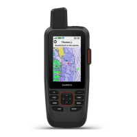
Explains the function of each button for device navigation and operation.
Detailed instructions for charging the device's battery using the USB port.
Guide on sending pre-written messages via the satellite network.
Instructions for composing and sending custom text messages.
How to track your location and share it on MapShare.
Steps for initiating, customizing, and canceling SOS emergency requests.
Understanding the map display, orientation, and measuring distance.
Using the compass for direction, calibrating it, and settings.
Connecting to a smartphone and managing notifications.
Finding and navigating to destinations and saved waypoints.
Planning, saving, and following routes between multiple points.
Configuring recording settings and managing current activities.
Accessing inReach and Active Weather forecasts and maps.
Overview of key tools like Waypoint Manager, Route Planner, and Tracking.
Finding, logging, and using hints for geocaches.
Accessing major settings like System, Display, Bluetooth, Wi-Fi, Map, Routing.
| Display Resolution | 240 x 400 pixels |
|---|---|
| Water Rating | IPX7 |
| Memory/History | 16 GB |
| High-sensitivity receiver | Yes |
| Ability to add maps | Yes |
| Waypoints/favorites/locations | 10, 000 |
| Outdoor recreation features | Yes |
| GPS | Yes |
| GLONASS | Yes |
| BeiDou | Yes |
| Galileo | Yes |
| Wireless connectivity | Bluetooth, Wi-Fi |
| inReach Features | Yes |
| NOAA charts | Yes |
| Weather | Yes |
| Satellite Communication | Yes |
| Display type | Sunlight-readable, color TFT |
| Battery type | Rechargeable lithium-ion |
| Interface | USB, NMEA 0183 |
| External memory storage | microSD card slot |
| Tracks | 250 |
| Navigation routes | 250 |
| Compass | 3-axis electronic compass |
| Map Support | BlueChart g3, LakeVü g3 |
| Sensors | Barometric altimeter |