Do you have a question about the Honda GL1800 Goldwing 2006 and is the answer not in the manual?
| Display Type | LCD |
|---|---|
| Voice Guidance | Yes |
| Route Calculation | Yes |
| Points of Interest | Yes |
| Interface | Touchscreen |
| Audio System Integration | Yes |
| Antenna | Integrated |
Provides an overview of the navigation system and its capabilities.
Highlights safety considerations and warnings related to using the navigation system.
Details the limitations of the navigation system, including GPS signal reception.
Describes optimal conditions and locations for receiving GPS signals.
Identifies areas and conditions that can negatively impact GPS signal reception.
Outlines the terms and conditions for using the navigation system software and CF memory card.
Provides a general overview of the navigation system's functions and operation.
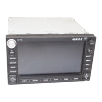
Explains the location and function of various controls on the motorcycle.
Details the procedure for turning on and activating the navigation system.
Summarizes the different types of screens and information displayed by the system.
Explains the components and information shown on the navigation map screen.
Details the Point Review Screen and its associated menu items.
Explains how to calculate and edit routes, including route preferences.
Summarizes the five major selections available in the system's Main Menu.
Guides the user through planning and taking their first trip using the navigation system.
Provides helpful tips and explanations to assist with understanding system features.
Details the functions of the buttons and controls located on the right fairing panel.
Explains the operation of the controls found on the left handlebar.
Describes the buttons and functions associated with the center display unit.
Covers the controls for operating the audio system components.
Categorizes the different types of screens available in the navigation system.
Details the various map layouts, map screen elements, and display options.
Explains the Main Menu and its various options for system navigation.
Describes the on-screen keyboard layout and how to use it for text input.
Explains how lists are compiled and displayed, often serving as gateways to other functions.
Details the Point Review Screen, which presents map plus information about a selected location.
Covers the screens for calculating routes, setting preferences, and editing existing routes.
Explains how to add or delete stops and rearrange the sequence of vias on a route.
Allows configuration of screen elements, including color, intensity, and map orientation.
Configure system elements like units, time format, and daylight savings settings.
Customize the opening and closing ceremonies shown when the system is turned on or off.
Displays GPS status, time, date, and current location.
Identifies software version, unit ID, and mapped areas.
Returns all optional settings to their initial factory defaults.
Lists the default settings for various system features.
Allows searching for saved favorite locations.
Locates the nearest points of interest or saved favorite places.
Retrieves previously searched locations from the system's history.
Searches for points of interest based on categories and subcategories.
Allows searching for locations by their specific name.
Enables routing by entering a street address, city, and state.
Locates destinations by specifying two intersecting streets.
Allows searching for a destination by city name.
Locates nearest highway exits or specific exit roads.
Guides the user through creating a new route or setting a destination.
Allows editing existing routes by adding, deleting, or sorting locations.
Explains how to add intermediate stops (vias) to an existing route.
Modifies an existing route based on preferences or selected 'avoid' options.
Describes how to use the White Arrow Point Locator to add a road as a via.
Allows recalculating a route to bypass a specific distance.
Guides the user on how to save current locations or cursor positions as favorites.
Explains the process of renaming existing favorite locations.
Details how to remove favorite locations from the system.
Describes how the system calculates a route back to the designated Home location.
Explains how to check and potentially change the designated Home location.
Details the procedure for removing the designated Home location from the system.
Provides definitions for terms commonly used within the navigation system.
Offers solutions for common problems encountered with the hardware, software, and features.
Explains various system messages and suggests appropriate actions to take.
Details operational limitations of the system, including GPS signal and database constraints.
Outlines the limitations and potential inaccuracies of the map database.
Provides contact information for Honda customer service and details on software upgrades.