Do you have a question about the Honda CR-V 2013 and is the answer not in the manual?
Explains the manual's formatting for printing due to content changes throughout the model year.
Warns about driver distraction from the navigation system and advises safe operation.
Notes potential conflicts with route guidance and system limitations.
Provides a quick overview of key navigation functions like destination entry and route selection.
Introduces the audio system features, sources, and controls like Voice Control and Bluetooth®.
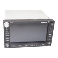
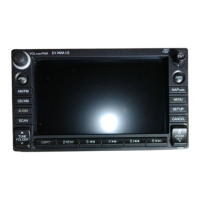
Identifies touch screen elements and buttons for navigation system operation.
Explains the function of the volume knob and the navigation joystick control.
Details the initial steps to activate voice commands by pressing the Talk button.
Instructs on how to speak a voice command after the system is ready.
Explains map orientation (North-up/Heading-up) and GPS signal strength indication.
Describes traffic status, flow indicators, and icons for various feature areas.
Explains the Map Screen and Guidance Screen views during route guidance.
Details manual display mode switching and turn-by-turn direction display.
Explains how to enter information using voice commands and phonetic spellings.
Describes entering information using touch screen characters and the joystick.
Provides step-by-step instructions for storing home addresses in the system.
Explains how to use the Go Home feature to navigate to your stored home address.
Guides on entering a destination by specifying city, street, and number.
Explains how to view routes, set route preferences, and select a destination.
Explains how to add up to four waypoints (pit stops) to an existing route.
Details methods to specify a new destination while en route.
Provides instructions on how to cancel the active route guidance.
Offers a tutorial on using the system's voice command functions.
Lists all available voice commands for each system function.
Addresses common problems like startup screen display, system reboots, and destination entry.
Provides solutions for difficulty recognizing voice commands and strange street name pronunciation.
Describes the automatic start-up process and language selection.
Details the voice control system components and command input handling.
Covers display and volume adjustments, guidance prompts, and basic settings.
Manages address books, home addresses, PIN numbers, user names, and destinations.
Configures rerouting, unverified area routing, and avoid area settings.
Adjusts clock settings, vehicle position, and off-road tracking features.
Allows resetting all settings to factory defaults and clearing speed dials.
Allows adjustment of screen brightness, contrast, black level, and volume.
Sets the number of guidance prompts based on distance to the guidance point.
Sets map units, keyboard layout, voice tutor, and command tips.
Allows selection of map and menu screen colors for Day and Night modes.
Explains the function of the illumination control button for display modes.
Details automatic adjustments via sunlight sensor and headlights.
Stores, edits, and deletes address entries in two user address books.
Sets or edits the first and second home addresses for frequent use.
Sets or changes a 4-digit PIN to protect personal addresses and home addresses.
Allows changing the user name for profiles (User 1 or User 2).
Manages the list of previously routed destinations for shortcut entry.
Details how to create new categories for address book entries.
Guides on deleting or editing existing categories in the address book.
Sets route recalculation mode to automatic or manual.
Determines if route guidance is used in unverified road areas.
Specifies areas to avoid when calculating a route.
Sets the distance from the route to search for waypoints.
Details methods for specifying areas to avoid using address or map input.
Automatically adjusts the clock for daylight saving time changes.
Automatically adjusts the clock based on driving through different time zones.
Sets clock format (12/24hr) and allows manual time adjustment.
Resets all clock settings to the factory default values.
Sets whether to display tracking dots ('breadcrumbs') on the map.
Manually adjusts the vehicle's current position displayed on the map screen.
Resets all setup settings to their factory defaults and deletes personal data.
Guides on how to enter a destination for route guidance using various methods.
Describes route calculation, preference changes, and viewing route options.
Explains how to follow route guidance, receive traffic info, and view map screens.
Covers controlling map icons, traffic incidents, and accessing map legends.
Details altering routes, adding waypoints, and changing the destination.
Explains how to continue a route after stopping the vehicle.
Guides on entering destination addresses by city, street, and number.
Selects a destination from stored addresses in the address book.
Selects a destination from the list of recently visited places.
Enters a place name to find it in the map database for destination.
Selects a place category to search for a destination.
Selects a destination by entering its phone number.
Specifies a location using latitude and longitude map coordinates.
Selects the intersection of two streets as the destination.
Manually selects an icon or location on the map as the destination.
Explains how to select a state or province during address entry.
Guides on selecting a destination city by name or current location.
Explains how to enter and select a destination street name.
Handles place names found in multiple categories by selecting a subcategory.
Displays places sorted by distance from the current location.
Searches for places within a radius of a specific city.
Searches for places using a keyword for destination entry.
Guides on storing subcategories into favorites for quick access.
Guides on deleting subcategories from the favorites list.
Guides on positioning the cursor and adjusting map scale for destination selection.
Initiates the route calculation menu after selecting a map location.
Sets the destination and displays the calculated route line on the map screen.
Explains route preference changes and viewing different route options.
Displays a map showing the destination location.
Explains how the route is displayed and tracked in real-time on the map.
Offers an alternative view for route guidance, including turn-by-turn directions.
Explains how the route line appearance changes based on street types.
Describes automatic route recalculation and off-road tracking (breadcrumbs).
Explains how voice guidance prompts are provided during navigation.
Guides on switching between map and guidance screens using the MAP/GUIDE button.
Details the display of the next guidance point on the multi-information display.
Explains how the system reroutes when deviating from the planned route.
Describes the display of 'breadcrumbs' for tracking paths off mapped roads.
Guides on how to access and use the Map Menu options.
Allows setting guidance points, freeway exits, and display modes.
Searches for the nearest place/landmark and sets it as destination.
Displays freeway exit details and allows adding destinations or waypoints.
Displays a list of guidance points on the route for user confirmation.
Selects the display mode for route guidance: single-screen or split-screen.
Displays map and guidance screens on separate, adjacent areas.
Displays map and guidance information simultaneously on the map screen.
Uses an icon bar to select which icons are displayed on the map screen.
Allows fine-tuning the display or hiding of icons within specific categories.
Explains display control, selection, and searchability of landmark icons.
Explains display control and searchability of traffic icons.
Selects traffic incidents to avoid on the route.
Recalculates a detour route to avoid traffic incidents.
Cancels the active route guidance and removes destination/waypoints.
Manually calculates a detour route to avoid upcoming obstacles.
Selects specific streets along the route to avoid.
Sets waypoints along the route using various search methods.
Manages the waypoint list, allowing deletion or reordering.
Searches for the nearest place/landmark and sets it as the destination.
Selects a new destination by choosing a location directly on the map.
Guides on entering a new destination via the Destination Menu screen.
Describes the audio system's capabilities, sources, and remote controls.
Explains how to reactivate the system after power interruption.
Guides on selecting FM/AM modes and tuning stations using preset keys.
Explains selecting XM modes and using preset keys for channels.
Guides on selecting disc mode and playing audio discs, including MP3/WMA/AAC.
Explains connecting and playing music from an iPod® via USB.
Guides on activating Pandora® and selecting the mode for music streaming.
Explains connecting and playing music from a USB flash drive.
Guides on selecting Bluetooth® Audio mode and switching to HFL mode.
Allows adjustment of sound settings like bass, treble, fader, and balance.
Details basic audio functions controlled via steering wheel buttons.
Provides general information about the audio system and its sources.
Explains how to connect standard audio devices via the console jack.
Guides on selecting FM1, FM2, or AM bands and tuning stations.
Explains how to select radio stations using preset keys.
Searches for FM stations by RDS category.
Displays text information broadcast by the current RDS station.
Controls the display of FM station names or frequencies.
Accesses the sound preferences screen for audio customization.
Controls the display of FM station names or frequencies.
Searches for FM stations broadcasting specific RDS category information.
Guides on selecting XM1 or XM2 channels for playback.
Explains how to select XM stations using preset keys.
Provides information on retrieving radio ID and subscribing to XM Radio.
Explains potential reception problems and circumstances for XM Radio.
Guides on selecting disc mode and inserting a disc for playback.
Explains controls for disc playback on the navigation screen.
Selects the Folder tab to display and navigate folders on discs.
Explains scan and play modes like Random All, Repeat Track.
Guides on changing folders and selecting tracks for MP3/WMA/AAC discs.
Guides on connecting an iPod® to the USB adapter cable.
Lists compatible iPod® and iPhone® models for the system.
Controls playback modes (Shuffle, Repeat) and sound preferences.
Searches for music using the iPod® menu by category.
Guides on activating Pandora® on iPhone® and selecting the mode.
Plays tracks randomly from stored Pandora® stations.
Controls Pandora® playback using like/dislike, station selection, and bookmarking.
Guides on connecting a USB flash drive to the USB connector.
Provides information on recommended USB flash drive size and compatibility.
Selects the Folder tab to display and navigate folders on USB drives.
Guides on pairing a phone and selecting Bluetooth® Audio mode.
Explains switching between Bluetooth® Audio and HandsFreeLink® calls.
Details basic audio functions controlled via steering wheel buttons.
Cycles through available audio modes like AUX, DISC, XM, Bluetooth®.
Guides on accessing HFL menus like Phonebook, Call History, and Phone Setup.
Explains how to make calls by number, phonebook, call history, or speed dial.
Explains how to answer or terminate incoming phone calls.
Outlines voice commands for operating the HandsFreeLink® system.
Displays received text messages and allows replies using fixed messages.
Guides on pairing a Bluetooth-compatible phone to the system for the first time.
Pairs an additional phone via the Phone setup screen.
Creates speed dial entries with voice tags for easy calling.
Assigns voice tags to speed dial entries for voice-activated dialing.
Deletes a specific speed dial entry from the system.
Turns the Bluetooth® connection on or off for paired devices.
Sets whether to automatically transfer calls when entering/exiting the vehicle.
Sets whether to automatically answer incoming calls after a delay.
Sets whether to provide notifications for incoming text messages.
Accesses the phonebook to select contacts for making calls.
Enters a phone number directly to initiate a call.
Outlines voice commands for operating the HandsFreeLink® system.
Lists voice commands for controlling Bluetooth audio playback.
Lists voice commands for operating the phone via HFL.
Lists voice commands for adjusting system settings.
Lists voice commands corresponding to on-screen selections.
Reads received text messages aloud and allows selection of actions.
Replies to received text messages using predefined reply messages.
Displays trip information like distance traveled and average fuel consumption.
Provides access to system/device information and map update details.
Views database, software, device, and vehicle identification information.
Guides on how to update the navigation system's map database.
Explains the rear camera display, guide lines, and view modes.
Views database, software, device, and vehicle identification information.
Guides on how to update the navigation system's map database.
Addresses startup screen, reboots, destination entry, and voice recognition issues.
Solves problems related to FM Traffic display and functionality.
Addresses routing discrepancies and vehicle position tracking problems.
Solves issues related to map updates, coverage, and database errors.
Addresses display dimness and rear camera image delays or brightness.
Answers common questions about clock, language, and system reset.
Lists error messages for Navigation System, Disc Player, iPod®/Pandora®, USB.
Explains the normal startup screen display and voice command requirement.
Explains touch screen function limitations while the vehicle is moving.
Guides on adjusting screen brightness for day and night driving.
Explains how to change or remove PINs and what to do if a PIN is forgotten.
Addresses why the 'Call' option might be grayed out in the Calculate Route screen.
Verifies FM signal, traffic icons, and potential temporary issues.
Explains routing differences compared to other systems and map database revisions.
Addresses issues with the vehicle position icon and GPS signal reception.
Explains conditions for elevation display and potential missing data.
Clarifies map coverage, including unverified areas and geographic limitations.
Guides on reporting errors found in the map database or points of interest.
Explains that dim display in cold weather is normal and will brighten.
Explains that display delay when shifting gears is normal.
Guides on adjusting rear camera display brightness using ZOOM IN/OUT.
Addresses clock changes due to time zones and DST features.
Explains how to reactivate the system after battery disconnection.
Guides on changing the system language for all screens.
Lists error messages for display temp, heat, and routing issues.
Addresses errors related to bad discs, mechanical issues, and unreadable tracks.
Lists error messages for iPod®/iPhone® and Pandora® connectivity.
Addresses errors for unsupported devices, unplayable files, and USB connectivity.
Guides on initializing the navigation system after power interruption.
Details limitations of GPS, Address Calculation, and Database accuracy.
Provides resources for resolving problems and reporting errors.
Provides information on navigation system map coverage areas.
Guides on purchasing and obtaining navigation system software upgrades.
Explains the availability and sources of traffic information.
Presents end-user license agreement terms, warranties, and disclaimers.
Guides on entering the security code after power interruption.
Explains the process of acquiring GPS information for system initialization.
Displays after initialization, requiring user confirmation for system startup.
Explains how GPS information locates the vehicle on the map screen.
Details GPS signal reception, potential interference, and accuracy limits.
Explains how addresses are approximated on the map due to database limitations.
Discusses map database accuracy, incompleteness, and limitations.
Describes verified vs. unverified areas and associated driving cautions.
Lists resources for resolving navigation and Bluetooth® issues.
Guides on reporting errors found in the map database or points of interest.
Provides contact details for Honda Customer Service assistance.
Advises consulting a dealer for specific unresolved issues.
Details the geographic map coverage areas provided by the navigation system.
Guides on purchasing and obtaining navigation system software upgrades.
Explains availability of updated traffic information in metropolitan areas.
Clarifies XM hardware presence but lack of XM broadcasting in certain regions.
Instructs on setting up XM audio service when shipping a vehicle.
Presents the end-user license agreement terms, warranties, and disclaimers.
Disclaims warranties regarding data quality, performance, and fitness for purpose.
Limits liability for damages arising from data use, defects, or conditions.
Lists general voice commands accepted by the system across all screens.
Lists voice commands specific to map and guidance screens.
Lists voice commands for operating the climate control system.
Lists voice commands for controlling the audio system sources and playback.
Lists voice commands for phone functions via Bluetooth® HandsFreeLink®.
Lists voice commands for adjusting system settings like brightness and volume.
Lists voice commands that correspond to on-screen selections for interaction.
Explains phonetic alphabet input for numbers, letters, and symbols.
Commands for displaying current location and toggling map icons.
Voice commands to change map scale and zoom levels.
Lists categories for finding places using voice commands.
Provides phonetic spellings for letters A-Z for voice input.
Provides phonetic spellings for accented letters and symbols.
Provides phonetic spellings for common symbols used in voice input.
| Touchscreen | Yes |
|---|---|
| Voice Recognition | Yes |
| Real-Time Traffic | Yes |
| Bluetooth Connectivity | Yes |
| USB Port | Yes |
| Display Type | LCD |
| Voice Control | Yes |
| Auxiliary Input | Yes |
| Navigation System | Yes |
| Traffic Information | Yes |
| Steering Wheel Controls | Yes |
| Rearview Camera | Yes |