Do you have a question about the Koden KGP-920 and is the answer not in the manual?
Procedure to prevent electric shock during repair work.
Precautions for cleaning to avoid dust inhalation.
How to prevent damage from static discharge to components.
Safe disposal procedures for LCDs containing mercury.
Symbol indicating potential injury or equipment damage.
Symbol indicating potential equipment malfunction.
Symbol indicating risk of electrical shock.
Symbol indicating a forbidden action.
Explanation of the Global Positioning System.
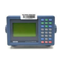
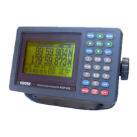
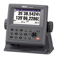
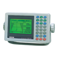
Description of the KGP-920 GPS navigator and its design standards.
Details the components included with the KGP-920.
Lists the software types used in the KGP-920.
Lists all standard items included in the KGP-920 package.
Details optional accessories available for the KGP-920.
Technical specifications for the GPS receiver module.
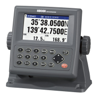
Specifications for the KGP-920 display unit.
Details data formats and ports for input/output.
Specifies power input voltage and consumption.
Outlines safe distances from compasses.
Lists operating temperature, humidity, and water proofing.
Provides physical dimensions and weight of the unit.
General considerations for installing the KGP-920 series.
Instructions for unpacking the equipment.
Guidance on inspecting components for damage.
Factors to consider when choosing installation locations.
Procedures for installing the display unit (table/flush).
Guidance on installing the GPS/Beacon antenna unit.
Details how to connect cables to the unit.
Explains the pin assignments for various connectors.
Checks to perform after the installation is complete.
Identifies and explains the functions of unit parts.
Instructions for turning the device on and off.
How to adjust display settings.
Explains how to navigate and select different display screens.
How to store current position data.
Operation of the Man Over Board function.
How to retrieve stored event or MOB positions.
Shows how to display navigational metrics.
Procedure for saving waypoint coordinates.
How to configure waypoint navigation.
Understanding and using XTE and CDI indicators.
Methods for managing route data.
Steps to set up and start route navigation.
How to set and recall anchor positions.
Features for displaying and managing tracks.
Identifies the different types of alarms.
Explains the reasons behind specific alarm notifications.
Procedures for configuring and disabling alarms.
Overview of the device's menu structure and navigation.
Settings related to GPS satellite reception and positioning.
Configuration options for DGPS functionality.
Options for position and compass compensation.
Settings for initial configuration like units and averaging.
Settings for data output formats and ports.
Procedures for initializing the device and managing memory.
Steps to set up Line of Position (LOP) displays.
How to save waypoint data in LOP format.
Procedures for correcting position data using LOPs.
How to convert LAT/LONG to Loran/Decca LOPs.
Routine checks and cleaning procedures.
Guides for diagnosing and resolving common issues.
Lists and explains error messages.
Details on digital communication standards and protocols.
Format for data input on the DATA 2 port.
Output data formats for DATA and DATA 2 ports.
Baud rate, level, current, sentence, and update rate.
Explains the structure of various output data sentences.
Diagrams and explanations of input/output circuits.
Steps to switch to external communication mode.
Procedures for transferring route data.
How to transfer a complete route.
How to navigate using a received route.
Handling of working route data transfers.
Explains error messages during data transfer.
List of geodetic systems and their abbreviations.
Table of Decca chains, codes, and zones.
| SBAS | Yes |
|---|---|
| Receiver Type | GPS |
| Channels | 12 channels |
| Update Rate | 1Hz |
| Protocols | NMEA 0183 |
| Weight | 300g |