Do you have a question about the Navman S100 and is the answer not in the manual?
Select a suitable position for above or below deck installation.
Instructions for securely mounting the instrument on a flat surface.
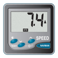
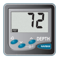
Use keys to scroll through main display functions like speed and log.
Procedure to turn the instrument's display backlight on or off.
Change temperature display between Celsius and Fahrenheit.
Reset average speed, maximum speed, and trip log values to zero.
Reset the total log value to zero using a specific key press duration.
Record time from power up in hours and minutes.
Operate the 5 and 10-minute countdown timers with audible alarms.
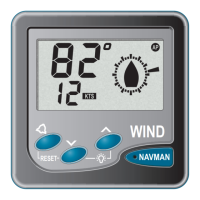
Enable or disable the sea temperature function and select display units.
Enter and use the instrument's simulation mode for testing.
Adjust speed display to match another craft or GPS receiver.
Calibrate log based on a known distance traveled and calculated correction factor.
| Auto | Yes |
|---|---|
| Marine (chartplotters, sounders) | No |
| Form factor | Handheld |
| Product color | Silver |
| Display diagonal | 4.3 \ |
| Display resolution | 480 x 272 pixels |
| GPS receiver | SiRFstarIII + InstantFixII |
| Internal memory | 128 MB |
| Storage capacity | 1024 MB |
| Processor model | Samsung S3C2450 |
| Operating system installed | - |
| Map view options | 2D/3D |
| Bundled software | Pre-installed Safety Camera Data |
| Depth | 13.5 mm |
|---|---|
| Width | 130 mm |
| Height | 78 mm |
| Weight | 150 g |