EasyManua.ls Logo

Nextar X3-08

Nextar X3-08
40 pages
To Next Page IconTo Next Page
Loading...
contents
Getting started
................................…………………………………….....…...........2
Starting
the
system...............…………………………………………………..............
2
Getting
a
GPS
signal........................….……………………………….....................
3
Entering
data
on
the
system
.…………………………………………….....................4
Moving
through
the
screens.........…………………………………...........................
5
Working
with
the
map...............…………………………………….............................6
Map
view
.......................……………………………………..........................................
6
Maneuver
detail.......……………………………………..............................................
6
Panning
the
map
..............………………………………………..................................
6
Route
list
.......................……………………………………….....................................
7
Location
and
POI
information
................…………………………………...................
7
Planning
your
route...........................…………………………………………...........
9
Setting
a
single
destination
..................……………………………………................
9
Using
an
address
as
a
destination.........………………………………….................
10
Using
an
intersection
as
a
destination...........………………………………….........
13
Using
a
Point
of
Interest
(POI)
as
a
destination
………………………………….......
17
Using
a
Favorite
destination
as
a
destination
.....…………………………………....
21
Using
a
Recent
destination
as
a
destination
...…………………………………........
22
Using
a
City
Center
as
a
destination
.......…………………………………………....
23
Adding
detours
and
stopovers
......…………………………………….........................
25
Detours
..............................…………………………………..…………………...........
25
Stopovers............................……………………………………...............……............
26
Managing
your
favorites
list
......……………………………………..................….......
28
Using Shortcuts
............................................………………………………………....
29
Setting
your
options
.......................…………………………………............…..........
30
Display options .......................................................……….................................... 30
Route options .......................................................…….......................................... 32
Speed alert .........................................................………......................................... 34
Volume…………………………………………………………………...…………………..35
Localization ..................………................................................................................ 35
Screen Display .……………........................................………….............................. 38
- 1 -

Other manuals for Nextar X3-08

Question and Answer IconNeed help?

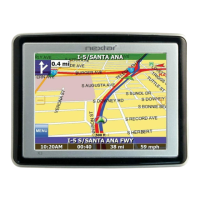
Do you have a question about the Nextar X3-08 and is the answer not in the manual?

Nextar X3-08 Specifications

General IconGeneral
BrandNextar
ModelX3-08
CategoryGPS
LanguageEnglish

Summary

Getting started

Starting the system

Initial procedure to power on the GPS device and begin operation.

Getting a GPS signal

Explains how to acquire satellite signals for accurate positioning.

Entering data on the system

Details the process of inputting information using the touchscreen interface.

Moving through the screens

Describes basic navigation between different screens and menus on the device.

Working with the map

Map view

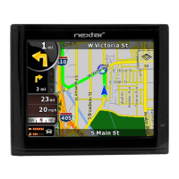
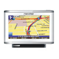
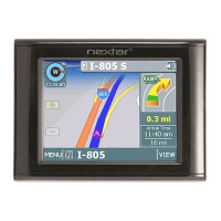
Overview of the map display, including current location and scale.

Maneuver detail

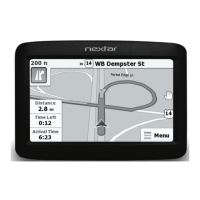
Information displayed for upcoming turns and route guidance.

Panning the map

How to move the map display to view different areas.

Route list

Accessing and viewing a list of route instructions or maneuvers.

Location and POI information

Finding details about specific map locations or Points of Interest.

Planning your route

Setting the home address

Procedure for saving and setting the user's home address for quick navigation.

Using an address as a destination

Step-by-step guide to entering a street address for navigation.

Using an intersection as a destination

How to set a destination by specifying two intersecting streets.

Using a Point of Interest (POI) as a destination

Selecting a destination from a list of Points of Interest like restaurants or attractions.

Using a Favorite destination as a destination

Navigating to locations previously saved in the Favorites list.

Using a Recent destination as a destination

Selecting a destination from the history of recently visited locations.

Using a City Center as a destination

Navigating to the general center of a city without a specific address.

Adding detours and stopovers

Detours

How to avoid specific roads or segments on a calculated route.

Stopovers

Adding intermediate points to a route before reaching the final destination.

Managing your favorites list

To manage your favorites list

Instructions for editing names or removing locations from the Favorites list.

Using Shortcuts

Shortcuts

Quick access to common destinations like Home, ATM, Gas, etc.

Setting your options

Display options

Customizing visual aspects of the map, like orientation, colors, and 3D view.

Route options

Configuring preferences for route calculation, such as method, ferries, and tolls.

Speed alert

Setting up audible warnings for exceeding speed limits.

Volume

Adjusting the audio output level for system alerts and voice guidance.

Localization

Configuring language, time zone, units, and TTS settings.

Related product manuals