Getting started
7
Copyright © 2007 Nokia. All rights reserved.
Digital cartography may be inaccurate and incomplete to
some extent. Never rely solely on the cartography that you
download for use in this device.
Downloading maps may involve the transmission of large
amounts of data through your service provider's network.
Contact your service provider for information about data
transmission charges.
You can also use Nokia Map Loader. This PC application
allows you to select and download maps of available
regions or countries to your PC and transfer them to your
Nokia E90 Communicator. You can also download voice
skins for turn-by-turn navigation. For more information,
see “Using Nokia Map Loader”, p. 19 and maps.nokia.com.
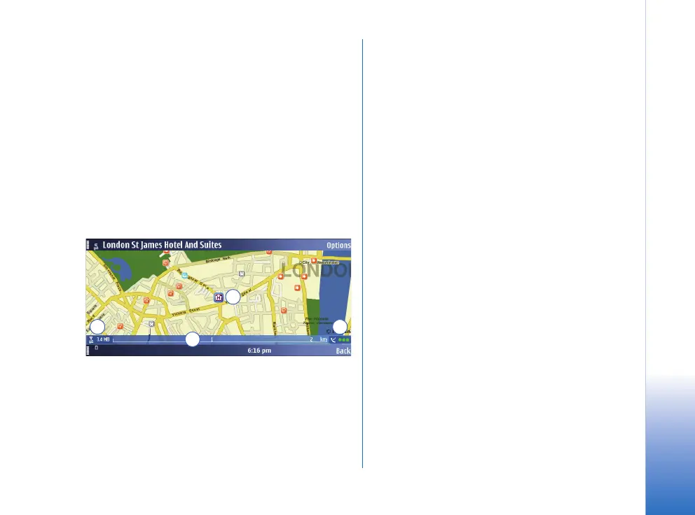
The details of the map are explained in the following:
1 GPS position / selected location – The blue square
indicates your current GPS position or a selected
position on the map. The map not only shows streets
and squares, but also points of interest such as
restaurants, cultural attractions, car parks, and so on.
You can define the depth of detail of the map by
choosing which types of locations are displayed.
One-way streets are marked with a red arrow pointing
in the direction in which the street can be driven.
2 Data transfer indicator and data counter – The data
transfer indicator shows any data transfer activity on
your device. The indicator blinks when data is being
transferred. The data counter displays the amount of
data transferred in the current session.
3 Scale bar – The scale bar shows the scale depending
on the actual zoom level. Through the scale bar, you
may estimate the distance between two points on the
map. The system of measurement used is displayed in
the middle of the scale bar (metric or imperial). You
can change the system of measurement in the Settings.
4 GPS signal indicator – The GPS indicator shows the
availability of the GPS signal, as well as its strength.
The strength is indicated by traffic lights next to the
satellite symbol. The more lights there are visible, the
stronger the signal.
When the device is searching for a GPS position, the
lights are blinking yellow.
When a GPS signal is detected, the lights appear
green. When no GPS signal is detected, the lights
appear red.
The map is oriented towards north by default. However,
during navigation, the orientation may change, for
example to improve the visibility of turns. Therefore, a
compass rose appears on the map during navigation,
displaying the orientation of the map.
1
2
3
4