Do you have a question about the Pioneer AVIC-F940BT and is the answer not in the manual?
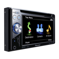
Describes functions of the eject, HOME, multi-control, MODE, and TRK buttons.
Initiates a search for a location using a street address.
Calculates the optimal route to your saved home address.
Searches for places like stores and restaurants from the database.
Searches for POIs using data stored on a microSD card.
Stores and allows selection of frequently visited locations.
Navigates back to the immediately preceding menu or screen.
Selects a destination that was previously navigated.
Allows searching for a location using its geographical coordinates.
Disengages the active route guidance and stops navigation.
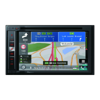
Displays details and status of the currently active navigation route.
Shows real-time traffic conditions affecting the route.
Display the Destination Menu and select the 'Address' option.
Choose the specific country for the address search.
Enter street, city, and other address information.
Verify the entered address and finalize the destination selection.
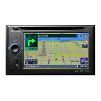
Indicates the name of the street for the next guidance point.
Shows the current system time.
Displays the projected arrival time at the destination.
Highlights the active navigation route on the map.
Marks the vehicle's current location on the map.
Shows the name of the street the vehicle is currently driving on.
Displays fuel efficiency or driving style information.
Provides tools for interacting with and manipulating the map view.
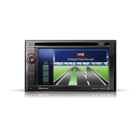
Shows the upcoming direction for route guidance.
Steps to access and modify the volume for navigation voice prompts.
Instructions for selecting and operating the FM radio function.
Guides through connecting a mobile phone via Bluetooth.
Details on importing contacts from a paired mobile phone.
Instructions for inserting and safely ejecting a microSD card.
Connect and control an iPod using the USB interface cable.
| Auto | Yes |
|---|---|
| Aviation | - |
| Marine (chartplotters, sounders) | No |
| Languages support | CZE, DAN, DEU, ENG, ESP, GRE, HUN, ITA, NOR, POL, POR, SWE, TUR |
| Eco Routes | Driving with these more fuel-efficient routes saves you money as well as reducing your impact on the environment. Your device can show you the route which has a lower environmental impact, using the driving data of millions of TomTom users. |
| DIN size | 2 DIN |
| Form factor | Fixed |
| Product color | Black |
| Map coverage | All Europe |
| Map view options | 3D |
| Number of countries covered | 44 |
| Display diagonal | 6.1 \ |
| Display resolution | 800 x 480 pixels |
| Native aspect ratio | 16:9 |
| Storage media type | Flash |
| Compatible memory cards | SDHC |
| Internal storage capacity | 4 GB |
| Audio formats supported | AAC, MP3, WMA |
| Image formats supported | JPG |
| Video formats supported | H.264, MPEG4, WMV |
| Bluetooth version | 2.0+EDR |
| USB 2.0 ports quantity | 1 |
| Supported radio bands | AM, FM |
| Preset stations quantity | 24 |
| Power supply | 200 W |
| Power source type | USB |
| Storage temperature (T-T) | -20 - 80 °C |
| Operating temperature (T-T) | -10 - 60 °C |
| Depth | 165 mm |
|---|---|
| Width | 178 mm |
| Height | 100 mm |
| Weight | 2510 g |