Do you have a question about the TomTom 4PN50 and is the answer not in the manual?
Instructions for mounting your TomTom PRO device in your vehicle.
Guidelines for choosing an optimal and safe mounting location.
Instructions on how to power the device on, put it to sleep, and turn it off.
Information about potential interference with electrical devices.
Steps to configure the device's language and initial settings.
Tips for ensuring optimal GPS signal reception and accuracy.
Steps to connect the PRO device to a TomTom LINK for WEBFLEET.
Steps to activate and connect the PRO device to the WEBFLEET service.
Control whether device usage information is sent to TomTom for service improvement.
Using a memory card for extra storage, custom POIs, and updates.
Steps to resolve issues when the device fails to start or respond.
Instructions on how to charge the device's battery.
Recommendations for maintaining the device's condition and warranty.
Benefits of using Wi-Fi for managing maps, software, and device content.
Step-by-step guide to connecting the device to a Wi-Fi network.
How to remove a previously connected Wi-Fi network from the device.
Information on system software and map updates.
Procedure for installing software and map updates.
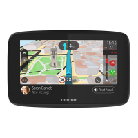
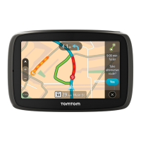
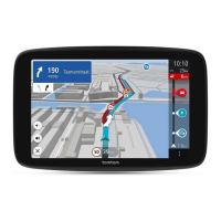
Overview of the map view, its interactive elements, and navigation.
Details on the guidance view for turn-by-turn navigation and route information.
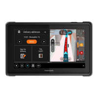
Explanation of the WEBFLEET panel and its displayed information.
Information displayed in the route bar, including arrival and traffic data.
How distances are shown in the route bar and its display options.
Details of the wide route bar, its display, and additional information.
Understanding driving performance indicators and advice.
Interpreting icons for fuel efficiency measurement against average values.
Explanation of alerts and advice shown in the route bar.
Buttons for reporting start, break, and finish times for work.
Buttons for changing logbook modes (Business, Commute, Private).
Buttons to report the working progress of orders.
Icon indicating connection status to WEBFLEET.
Accessing quick menu options like marking locations or changing speed limits.
Overview of main navigation buttons like Search/Drive To and Drive Home.
Accessing and navigating to recent destinations.
Clearing or changing the current route or track.
Reporting working times to the office via WEBFLEET.
Reporting trip modes for keeping a logbook.
Viewing and managing assigned orders.
Reading, replying to, and sending messages.
Accessing tips, tricks, and statistics for driving performance.
Accessing saved places like Home and Work.
Accessing saved routes.
Starting and stopping the recording of a track.
Using voice commands to control the device.
Locating parking lots and garages.
Locating gas stations.
Reporting new safety camera locations.
Explanation of smaller buttons and symbols in the Main Menu.
Adjusting the volume for voice instructions and warnings.
Learn how to control the device using touch gestures.
How to customize the order of buttons in the Main Menu.
Overview of TomTom Traffic service for real-time traffic information.
Explanation of the RDS-TMC traffic message channel.
How traffic incidents are displayed and interpreted on the map view.
How traffic information is shown in the route bar and its interpretation.
Explanation of symbols used for different types of traffic incidents.
How the device warns you when approaching a traffic jam.
Methods to avoid traffic jams on your current route.
How to choose and accept faster routes suggested by TomTom Traffic.
Assistance with highway exits and junctions by showing correct lanes.
Understanding how speed limits change based on time or conditions.
How vehicle type affects route planning and avoids restrictions.
Steps to select and configure vehicle type for optimal routing.
Route planning considerations for larger vehicles like buses and trucks.
How to see route restrictions for specific vehicle types on the map.
Comparing Quick Search and Step-by-Step Search for destinations.
How to find places and navigate using the quick search feature.
Guidance on typing search queries for addresses and POIs.
Using the search input box and selecting search types (Whole map, Near me).
How to interpret and use search results shown in lists or on maps.
How ZIP codes are used for searching and their variations by country.
Using mapcodes for location identification where addresses are unavailable.
Visual guide to common Point of Interest (POI) type icons.
Steps to plan a route to a specific address using quick search.
Steps to plan a route to a city center using quick search.
Steps to plan a route to a Point of Interest using quick search.
Searching for POIs online via TomTom Places.
Steps to plan a route by interacting directly with the map.
Navigating to saved locations stored in My Places.
Steps to plan a route using latitude and longitude coordinates.
Using mapcodes to plan routes in areas without standard addresses.
How to plan and save routes before starting your journey.
Modifying the route's starting point to your current location.
Converting the route's starting point into a stop.
Locating parking lots and garages.
Locating gas stations.
Overview of the step-by-step search method for finding destinations.
Using the keyboard and options for step-by-step search input.
How to interpret and use step-by-step search results.
Using ZIP codes for searching with the step-by-step method.
Detailed steps for planning a route to an address step-by-step.
Steps to plan a route to a Point of Interest using step-by-step search.
Steps to plan a route to a city center using step-by-step search.
Searching for POIs online using step-by-step method.
Planning a route by interacting directly with the map step-by-step.
Navigating to saved locations using My Places step-by-step.
Planning routes using coordinates step-by-step.
How to plan and save routes before starting your journey.
Overview of options available in the Current Route menu.
How to add a stop to your planned route.
Saving a new or modified route to your My Routes list.
Selecting different route types like Fastest or Shortest.
Changing the sequence of stops in your current route.
How to find alternative routes around blocked roads.
Selecting specific sections of a route to avoid.
Methods to find and select alternative routes.
Choosing between Fastest, Shortest, Eco-friendly, and other route types.
Options to avoid features like toll roads, ferries, and unpaved roads.
Using the route bar to avoid specific incidents or route features.
Adding stops to your current route from the menu or map.
Removing a stop from your current route.
Skipping the next stop on your planned route.
Changing the sequence of stops in your current route.
Overview of reporting start, finish, and break times.
Identifying yourself with a PIN for personalized work time reports.
Steps to report your working times to WEBFLEET.
Buttons for managing work status: Start, Pause, Finish.
Handling work status reporting when powering the device on or off.
Selecting logbook modes like Business, Commute, or Private.
Icons representing different logbook modes.
Overview of service, delivery, and pick-up orders stored on the PRO.
Buttons to report the progress of an order.
Steps to view, start, cancel, or suspend orders.
Criteria and methods for sorting the list of orders.
Sending status messages to the office from the device.
Temporarily suspending or changing the current order.
Switching to a different order, even if the current one is unfinished.
Steps to cancel an order and optionally delete it.
Overview of messages received and stored on the Driver Terminal.
Reading, replying to, and deleting messages.
Sending text and predefined messages to the office.
How OptiDrive provides driving style statistics and advice.
Viewing statistics and insights for your last trip.
Tracking the development of your driving style over time.
Ensuring continuous connection to the TomTom LINK for full functionality.
Ensuring continuous connection to WEBFLEET for service benefits.
Settings controlled by the office, like logbook mode and work reporting.
Using My Routes to save and retrieve routes and tracks.
Definitions and differences between routes and tracks.
Information on GPX and ITN file formats for routes and tracks.
Steps to save a planned route into the My Routes list.
How to select and navigate a previously saved route.
Navigating to a specific stop within a saved route.
Adding a new stop to a saved route directly from the map.
How to record your driving path as a track.
Navigating along an imported or recorded track.
Removing routes or tracks from the My Routes list.
Exporting recorded tracks as GPX files for sharing or backup.
Importing GPX or ITN files from a memory card.
Overview of voice control capabilities and requirements.
Methods to activate voice control using wake-up phrase or menu.
Creating a personalized wake-up phrase for voice control.
Interpreting the elements and information on the voice control screen.
Tips to improve voice control accuracy and understanding.
Examples of commands for global functions and navigation.
Using alternative phrasing for commands to improve recognition.
Planning a trip to an address using voice commands.
Using voice commands to navigate to your home location.
Using voice commands to navigate to a Point of Interest.
Adjusting device settings, like volume, using voice commands.
Overview of camera warnings and safety hazards alerts.
How camera warnings adapt when crossing country borders.
How the device warns you when approaching a safety camera.
Configuring warning preferences for cameras and hazards.
Instantly reporting new safety camera locations.
Confirming speed traps or reporting their removal.
How the device automatically receives updates for camera and hazard locations.
Explanation of danger zones and risk zones warnings.
How the device warns you when approaching danger or risk zones.
Configuring warning preferences for danger and risk zones.
Using My Places to select and save locations easily.
Steps to set your home and work locations in My Places.
Methods to change your saved home location.
Adding new locations to My Places from the map or search.
Adding locations found via search to My Places.
Temporarily marking and saving the current location to My Places.
Removing recent destinations from the My Places list.
Removing saved locations from My Places.
Importing and using community POI lists from an SD card.
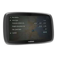
Settings for driver identification, vehicle connection, and profile.
Identifying yourself as a registered driver and entering PIN.
Connecting to a TomTom LINK device and managing vehicle settings.
Setting vehicle type, dimensions, weight, and maximum speed.
Choosing your vehicle type from a list or entering 'Others'.
Entering vehicle dimensions, weight, and maximum speed.
Entering your vehicle's license plate number.
Adjusting the device odometer to match the vehicle's odometer.
Controlling read-aloud settings for messages and orders.
Changing display, route bar, and guidance view appearance.
Adjusting theme color and screen brightness (Day/Night).
Customizing arrival information and route information displayed.
Configuring how remaining distance, time, and arrival info are shown.
Choosing which POIs and route details appear in the route bar.
Customizing street name display and guidance view style (2D/3D).
Adjusting automatic zoom behavior for turns and intersections.
Configuring route planning preferences and avoiding road features.
Settings for automatically taking or being asked about faster routes.
Selecting preferences for Fastest, Shortest, Eco-friendly, etc. route types.
Options to avoid features like toll roads, ferries, and unpaved roads.
Connecting to Wi-Fi networks and managing advanced options.
Advanced Wi-Fi security options like EAP method and certificates.
Configuring proxy server settings (None, Manual, Auto-Config).
Choosing between DHCP or static IP address assignment.
Selecting the map stored in internal memory or on memory cards.
Checking for and installing software updates for the device.
Customizing warning types (spoken, sounds only) and specific alerts.
Choosing voices and configuring spoken instructions (arrival time, road numbers).
Configuring voice control activation, wake-up phrase, and route acceptance.
Changing device language, country, keyboard, and units.
Accessing device information (About), sending data, battery, GPS, and reset options.
Accessing help topics, device information, and support contacts.
Checking Bluetooth and mobile network connection status.
Links to online resources for additional help and warranty information.
Steps to find product certification details like ICASA approval.
Critical safety warnings regarding device use, setup, and care.
Guidelines for responsible and attentive use of the device while driving.
Important considerations for using the device with large or commercial vehicles.
Recommendations for mounting the device to ensure safety and visibility.
Recommendations for device proximity to pacemakers to avoid interference.
Consulting physicians regarding potential interference with medical devices.
Requirement to turn off device in potentially explosive atmospheres.
Instructions for cleaning and maintaining the device.
Information on the device's safe operating and storage temperature ranges.
Details about the lithium-ion battery and its care.
Disposal instructions for electronic waste in the EU/EEA.
Device compliance with EU radio wave exposure limits.
Device compliance with US radio wave exposure limits (FCC/IC).
State laws regarding device mounting and driver responsibility.
FCC compliance statements and interference guidelines.
Statement on RF exposure limits and device operation.
Information on disabled country code selection for US/Canada.
Contact details for TomTom, Inc. in North America.
Device compliance with IC radiation exposure limits.
Indicates compliance with Australian regulations (RCM).
Indicates compliance with New Zealand regulations (R-NZ).
Indicates ICASA approval for the device in South Africa.
Electrical specifications: voltage and current ratings.
Device power consumption figures at different voltages.
Voltage rating for the car charger.
Compliance with radio frequency exposure limits.
Identifies the specific TomTom PRO models covered.
Device compliance with EU radio regulations and frequency bands.
Information regarding copyrighted software licensed under GPL.
Acknowledgement of Bluetooth SIG, Inc. trademarks.
Acknowledgement of Wi-Fi Alliance® trademarks.
Identifies TomTom Telematics B.V. as the warranty provider.
Details the coverage period and conditions for hardware defects.
Exclusions from warranty coverage, including wear and tear, damage.
Procedure for contacting TomTom and returning hardware for repair/replacement.
Notes on limitations of damages and legal rights under national legislation.
Disclaims liability for indirect damages and limits liability to purchase price.
| Display Resolution | 480 x 272 pixels |
|---|---|
| Lifetime Maps | Yes |
| Battery Life | Up to 2 hours |
| Internal Memory | 8 GB |
| Bluetooth | Yes |
| Voice Control | Yes |
| Screen Size | 5 inches |
| Display Type | LCD |
| Maps | Preloaded maps of North America |