Do you have a question about the Volvo NAVIGATION SYSTEM (VNS) and is the answer not in the manual?
Explains Easy and Advanced user modes and their differences.
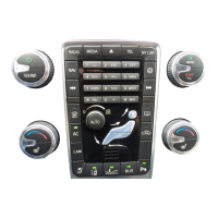
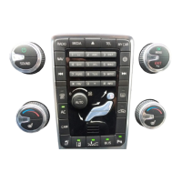
Details the physical locations and functions of navigation controls.
Describes how to switch between Easy and Advanced modes.
Step-by-step instructions for updating system and map data via DVD.
Explains the functions of the navigation control and remote control.
Describes how to perform general searches and interpret results.
Details various settings available in Advanced mode.
Refers to page 24 for details on navigation controls.
Details various system settings available in Easy mode.
How to set a destination by selecting a point directly on the map.
Guides for setting a destination via address, zip code, or map point.
How to search for a destination using a zip code.
Options to avoid roads, traffic problems, and specified areas.
Overview of traffic information reception and settings.
Settings for route calculation and avoidance preferences.
Options for POI selection, map view, compass, and current location display.
Selecting POI types and searching for specific points by name.
Guides on making and editing an itinerary with multiple stops.
How to view information about the next destination in the itinerary.
Steps to select a destination by address, including state, city, street.
How to search for Points of Interest (gas stations, hotels, etc.).
Switching between Easy and Advanced user modes.
Function to avoid driving through specific areas by defining them on the map.
Adding a location as a destination in an itinerary.
Accessing, adding, and managing previously stored destinations.
Steps to create an itinerary with multiple stops.
Storing up to 250 destinations for reuse in itineraries.
Option to avoid highways/freeways when calculating a route.
Using street numbers for specific destination entry.
Saving a location for later use in Set destination.
Settings for voice, language, colors, screen saver, help, and units.
Searching for POIs by name, around the car, along the route, or along a street.
How to set a destination by selecting a point directly on the map.
Actions like delete, move, adjust, and store for itinerary items.
Saving a map location with custom symbol and name.
Initiating navigation after setting a destination.
Searching for POIs around the car, along the route, or on a highway.
Function to avoid driving through specific areas by defining them on the map.
Setting route options to avoid traffic problems before starting guidance.
| Category | Car Navigation system |
|---|---|
| Manufacturer | Volvo |
| GPS | Yes |
| Voice Guidance | Yes |
| Bluetooth | Yes |
| USB Port | Yes |
| SD Card Slot | Yes |
| Name | Volvo NAVIGATION SYSTEM (VNS) |
| Map Updates | Yes |
| Compatibility | Volvo vehicles |