12
2.3 Navigation view
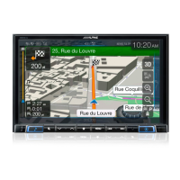
The navigation view is the main screen of Alpine Navigation System that shows the planned
route on a map. Alpine Navigation System works with digital maps which are not simply the
computerised versions of traditional paper maps. Similarly to paper road maps, the 2D mode
of digital maps shows you streets and roads. Elevation is also illustrated in colour.
The navigation view displays the following screen buttons, data fields, and route information
on the map during navigation:
Some buttons, fields, or icons may not be available in your product version.
The current position is displayed as a blue arrow by default.
When there is no GPS position, the current position marker is
transparent and it shows your last known position. See page 14.
The dot near the arrow shows the GPS position as perceived by
the GPS receiver. See page 14.
The planned route is displayed as an orange line.
 Loading...